
If you are looking for little crowds and don’t want to rent a jeep and cross rivers, then East Iceland might be a great place to go! East Iceland, also known as the Eastfjords, is full of off-the-beaten-path places, amazing zig-zag bays called fjords, and super charming, tiny coastal towns.
We’ve spent a lot of time in East Iceland over several years – both in summer and in winter – and we’ve gathered quite a long “shortlist” of our favorite Eastfjords spots. Going in winter? Check out our Best Winter Places in East Iceland piece too!
East Iceland in a nutshell
- You don’t need a jeep. Most of the places in East Iceland are reachable with an ordinary 2WD rental car. Only highlands like Askja require a 4×4 with unbridged river crossings.
- Best time to go: June to September, when the mountain roads and hiking trails open. Many places are accessible year-round.
- Almost everything is free. Only a few spots charge admission, like Vök Baths and the Laugarfell hot pools.
- Crowds are rare. Outside Seyðisfjörður, Hengifoss and Stuðlagil, you will often be completely alone, even in August.
What East Iceland is best known for:
- beautiful little towns of Seyðisfjörður, Fáskrúðsfjörður or Borgarfjörður Eystri
- day hikes to stunning hidden spots like Stórurð or Brúnavík beach
- one-of-a-kind waterfalls of Hengifoss, Strútsfoss or Klifbrekkufossar
- scenic roads like Öxi or Loðmundarfjarðarvegur (F946)
- wild hot springs and hot lagoons such as Vök Baths or Laugavallalaug
Fáskrúðsfjörður
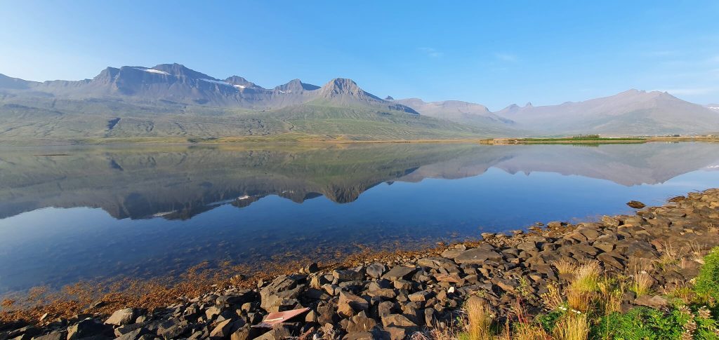
Fáskrúðsfjörður is one of our favorite hidden gems of the East and for sure one of the top Eastfjords spots
Why Go
If you asked me what my favorite town in East Iceland is, I would say immediately: Fáskrúðsfjörður. It’s hard to describe why, because there’s really nothing super important here other than a fish factory. But I guess that’s the reason.
Some other reasons might be a super picturesque, yet totally calm fjord, with unbelievable views both in summer and winter. And zero tourists. All of them are typically in Seyðisfjörður. The mountains above Fáskrúðsfjörður make some of the most beautiful reflections in the fjord below, which you can see in Iceland. That’s enough for us.
Tip from a Local
- We recommend booking accommodation here, because it’s typically cheaper than in bigger towns and much quieter. The higher the accommodation’s location, the better the view over the fjord.
- There are not many food options in Fáskrúðsfjörður, but the one present is great. Go have a fish soup in Café Sumarlína or try some of their other local delicacies. The specialty here is the local fish. The place looks like a pub, but their cuisine is delicious!
Our Experience
We stayed overnight in Fáskrúðsfjörður both in summer and in winter and loved it both times. If you want to calm down and just enjoy the beautiful scenery, then this is the town to go to. A hidden gem that no other blogs write about for sure.
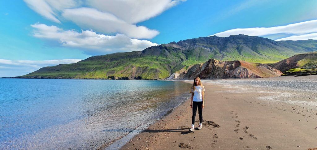
Brunavík beach is one of our really favorite places in the Eastfjords
Why Go
A hike to Brunavík beach on a sunny day is one of those hikes you’ll never forget in your entire life. On such a day, Brunavík beach shines with amazing colors and contrasts everywhere around – sea on the side, mountains in the back, and sand underneath your feet.
The main bonus? Nobody around! At least most of the time. While everyone visits Borgarfjörður Eystri because of the puffins, only a fraction of visitors actually go for a hike here. Yet, it’s one of the best hiking bases in all of Iceland. And Brunavík is one of the most beautiful hikes from Borgarfjörður Eystri.
Tip from a Local
- Bring water, food, and take your time. You’ll love it. The shortest trail to Brunavík from Borgarfjarðarhöfn is 4km long (2.6mi) and will take you about 1.5 hours one way to finish. It’s pretty straightforward and well-marked, yet there are occasional steeper inclines and declines, nothing too bad.
- If you don’t like out-and-back hikes, you can also do a longer loop trail. It’s about twice the length (15km / 9.5mi) and will add about 2 more hours to your hike, making it a 5-6 hour trek.
Our Experience
We hiked to Brunavík on an incredibly warm and sunny September day. The views from the highest point of the hike were incredible in all directions. Both – back over Borgarfjörður, but most importantly, right in front of you – the ones over Brunavík.
Elevation gain was about 300m, which wasn’t too bad, but of course made us sweat on a warm day. We drank all our water, so bring enough. We hadn’t met anyone during the first leg of the hike and were alone at the beach. The photos we were able to take just with our cell phones were simply stunning. Judge for yourself 🙂 And the solitude of the beach was even better.
On our way back, we met a larger group of hikers, maybe a guided hiking tour. Again, nothing too bad, far away from crowds. The views kept impressing us and definitely convinced us to return here one day.
Strútsfoss waterfall
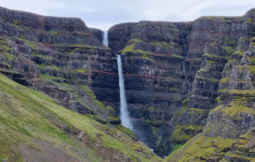
Strútsfoss is an almost unvisited hidden gem of the East
Why Go
Contrary to its Instagram friend Hengifoss, you’ll rarely meet other people near Strútsfoss. And it’s equally, if not even more beautiful, than Hengifoss. Why is that?
Well, of course, there are a few caveats. First, not many people know about it. Second, you have to drive a bit more to reach the trailhead. Third, you have to hike to it. Fourth, you cannot really come close to it (or at least not safely), so the viewpoint is a bit distant. Is it worth it in our opinion? Totally!
Tip from a Local
- Check the map before you go. Find “Strútsfoss car park“. This is where you can leave your car. Don’t leave the car at the farm Sturluflöt. You can reach the small car park by a paved road 935 from the Hengifoss area.
- A relatively easy marked hiking trail will lead you all the way to the main viewpoint. We don’t recommend doing the hike in winter, as signs might get harder to find and the terrain might be dangerous with lots of snow.
Our Experience
We hiked Strútsfoss on a beautiful August day. We didn’t know what to expect, as there had been basically no information at all about the place at the time of our visit. Only the infographic at the car park.
That being said, the hike was easy and actually felt quite relaxing after all our long hikes, which we had taken over the previous days.
The hike starts as a tractor road and then somehow transforms into a stony path. After about 1 hour, you’ll reach the point with a distant but clear view of Strútsfoss.
It’s theoretically possible to continue further, but it involves hiking on unmarked trails and treacherous river crossings. We don’t recommend doing that without a local guide.
Laugavallalaug hot spring
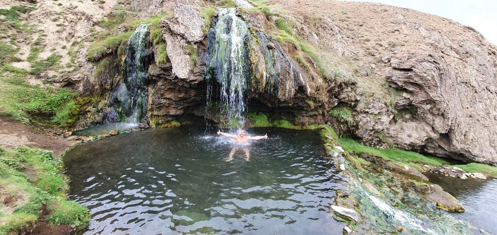
Laugavallalaug hot waterfall spring in the eastern Icelandic Highlands
Why Go
Like Icelandic hot springs? Then what about a hot waterfall? That’s exactly what Laugavallalaug is! Hidden in the eastern Icelandic highlands in the middle of nowhere between Askja and Stuðlagil Canyon, it’s one of the very few hot springs that offer a truly raw and wild experience.
Tip from a Local
- Laugavallalaug is a summer-only destination (July to September). It’s under snow for the rest of the year. The easiest way to reach it is from the south by roads 910 and F910. No river crossings, but a pretty bumpy ride. A 4×4 is compulsory.
- If you want to maximize your day in this area, you can visit Askja, Stuðlagil Canyon, and Laugavallalaug in one day. It will be a super long day, but all are in the same area. Take a proper 4×4 car (the bigger, the better), leave early in the morning, and plan for a late return. Ideally, choose a day with no fog or rain. A tough task, though.
Our Experience
Laugavallalaug is one of our favorite hot springs in Iceland. It’s not for everyone. The changing rooms are just simple, open-air cabins, and you have to take a short, steep walk down to reach the hot spring itself. Then, there’s a lot of algae in the pool. But the reward is worth it. Laugavallalaug doesn’t just feel like a different planet, it is a different planet 🙂
When near Askja or Stuðlagil, we always aim to stop here as well. A great, wild retreat for all hot spring lovers. Beware, though, you’ll never be alone here. There are a lot of curious sheep everywhere around!
F946 road
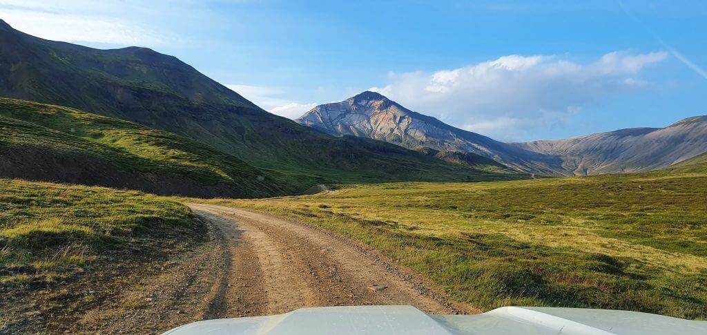
F946 – Loðmundarfjarðarvegur, a scenic F-road in Eastern Icelandic highlands
Why Go
Highland F-road F946, in Icelandic Loðmundarfjarðarvegur, is by far the most scenic road you can drive in East Iceland. It’s also one of the most remote roads in the Eastfjords.
On a sunny day, hills next to the road shine with unbelievable colors. And, as is often the case in Iceland, you will once again feel like you’re on another planet. Something like a 13th planet in Iceland already 🙂
Tip from a Local
- F946 is typically open from July until September. 4×4 is compulsory. There are no river crossings, only small streams to cross. But the road is pretty steep. Not for you if you’re afraid of steeper drives. Pick your car accordingly so that you’ll feel safe on the road like this. Our pick was a Land Cruiser.
- Check www.trafficinfo.is and en.vedur.is. You want the road to be passable (green mark on the map). We also wouldn’t drive it in heavy fog. No views. Doesn’t make much sense.
Our Experience
We drove F946 on an amazingly beautiful early September day full of sun and blue skies. Ideal. Even in such amazing weather, we felt a bit scared by the steepness of the roads. Or at least my wife did. Bear that in mind.
We met one local in his truck driving in the opposite direction and had to pull off to the side of the road so that he could pass safely. Be sure to always look far ahead. You don’t want to be doing this on a steep hill.
After driving all the mountain passes, we eventually reached the end of F946 at Klyppstaðarkirkja church in scenic and remote Loðmundarfjörður. Here we met quite a big group of local hikers on their multi-day trek. There’s nothing special at the end of F946, just super calm scenery and peace.
Seyðisfjörður
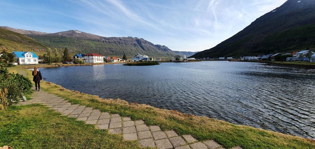
Seyðisfjörður is by far the most popular and lively town in East Iceland
Why Go
Seyðisfjörður is by far the most visited and most popular town in the Eastfjords. And for a reason.
First, it’s the only town in East Iceland where huge ferries and cruise ships stop. Second, it has a super charming city center with colorful houses, making it a great spot for photographers. Third, you have quite a lot of high-quality accommodation and food options for such a tiny village.
Tip from a Local
- Come by car. Seyðisfjörður is easy to explore on foot. However, if you want to head further away from the city to spots like Gufufoss waterfall, or even Stuðlagil Canyon or Vök Baths, you don’t have many options. There’s no car rental, no taxi, and no buses. Only private tours.
- Spend a day or two. While one afternoon might be enough to stroll around the town, to fully soak up the Seyðisfjörður vibe, you might need one or two days. There are definitely enough things to do, at least in summer. Be it several beautiful hikes like Vestdalur, the great local cuisine, and the coffee scene, or the Bjólfur viewpoint over the city.
Our Experience
We’ve been to Seyðisfjörður several times, both in summer and in winter. If there’s a cruise ship at the dock, be ready for crowds. But it’s not too bad. And still worth the great fjord views.
In winter, it’s an entirely different experience. We even got stranded for about an hour on our way to Seyðisfjörður. You’ll have to take the mountain pass, which can get stuck with snow during snowstorms. Yes, there’s a plow, but sometimes it just can’t clear the road fast enough.
We took a winter Vestdalur hike – easy and rewarding in summer, and quite an expedition in winter. Gufufoss is an easy stop along the road.
The best viewpoint over the city is from the Bjólfur avalanche barriers. Summer only. You can reach them by a 4×4 car, but it’s not for the faint of heart. The road is pretty steep. An alternative is to hike it instead.
Stórurð hike
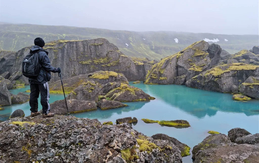
Stórurð hike in the highlands of east Iceland near Borgarfjörður eystri
Why Go
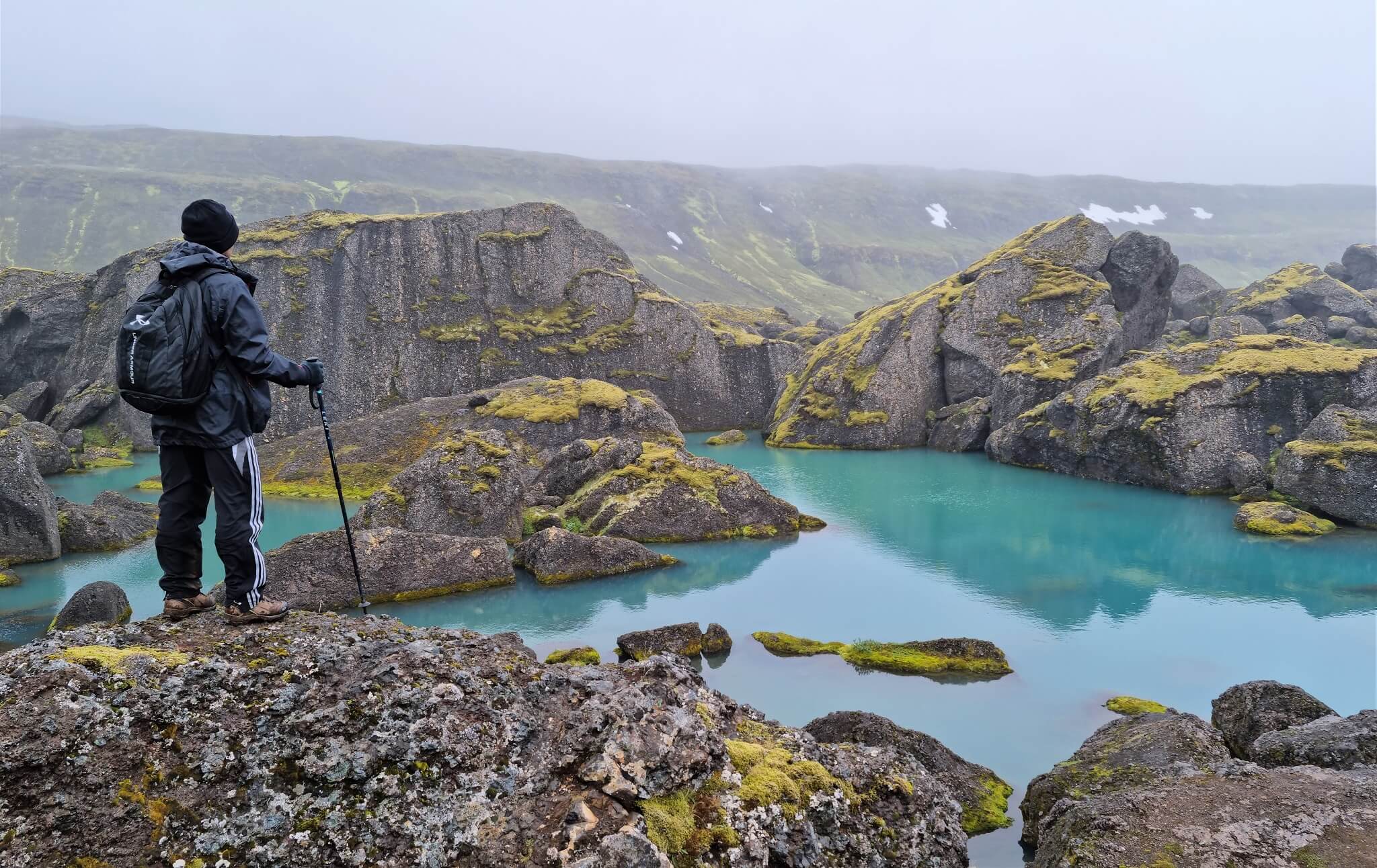
Stórurð is one of the most beautiful places in East Iceland, hidden far away from tourist crowds. It’s a sapphire-blue lake carved within massive stones. It sits right in the middle of the mountain range Dyrfjöll (or better said, right beneath it).
Stórurð looks like a place built by big trolls. The atmosphere of the place is super surreal, especially on a foggy day, as we experienced on our first visit. For us, it’s a must-see when in the Eastfjords.
Tip from a Local
- Don’t go in bad weather. As with all longer hikes in Iceland, it’s best to wait for the best weather possible. This means no heavy rain, no heavy fog, and/or no heavy wind. We went in light rain and light fog, and it was OK. Anything worse than that wouldn’t be OK anymore, because you won’t see a thing.
- Njarðvík trail is the easiest. There are several hiking trails to Stórurð, with the two most popular ones being the Njarðvík trail and the Vatnsskarð trail. Njarðvík is the easier one.
- Go in summer and ask locals for conditions. If you go early in summer, there might still be snow on the trails. It’s always best to ask locals about the conditions. The safest bet is late summer – i.e. August or September.
Our Experience
We hiked the Njarðvík trail to Stórurð on a semi-sunny, semi-foggy, semi-rainy August day. Textbook Icelandic weather. This made the initial views from the hike back over the fjord a bit distorted, but it wasn’t that bad.
This hiking trail to Stórurð is also doable for families, but once again, try to go in as good weather as possible.
The main reward comes in the end. The colors of Stórurð lakes have really impressed us, and we’ll surely come back. There are many great photo spots and you will rarely meet many fellow co-hikers in here.
Askja
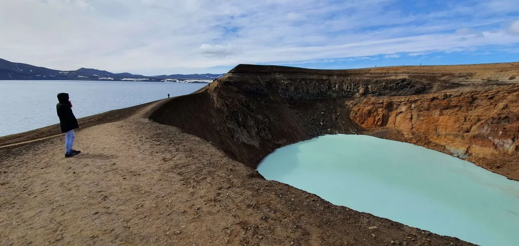
Our visit of Askja volcano area
Why Go
If you are into remote places, the Icelandic highlands, and don’t mind a longer, bumpy drive with a 4×4 car, then Askja is your dream place. Well, at least ours!
Askja is a huge volcanic lake in the middle of nowhere (a.k.a. Icelandic volcanic desert), and right next to it sits a smaller “Víti” caldera lake with warm, shiningly blue water.
Tip from a Local
- If you are brave enough, you can hike down into Víti and bathe there. It’s warm, but not hot. BUT (a huge but!). This area still has fresh volcanic activity, so you should always consult or visit rangers in Dreki huts along the way, in advance. Definitely consult them about the bathing possibility!
- There are two main ways to reach Askja – the northern one via F88 or the eastern one via F905. Then they both continue via F910 and F894 all the way to Askja. F88 has easier terrain, but one tricky river crossing, which can be small but also large depending on conditions. F905 is much bumpier, but the river crossings are more stable, so this is typically a safer choice.
- We wrote a detailed guide to Askja to help you plan your trip
Our Experience
Askja is one of our favorite places in Iceland, as such – remote, beautiful, one-of-a-kind, and this “you’ll never forget it” place. That means it’s surely one of the top places to visit in East Iceland. But only if you have the guts. It’s gonna be a long day!
We’ve been to Askja several times and highly recommend scouting for non-foggy weather (and ideally also no heavy rain). Fog or heavy rain can make a drive very uncomfortable.
We also often combine it with a visit to Stuðlagil Canyon, Laugavallalaug hot spring, or Hafrahvammagljúfur canyon. Just be aware of a really long day.
Hengifoss waterfall
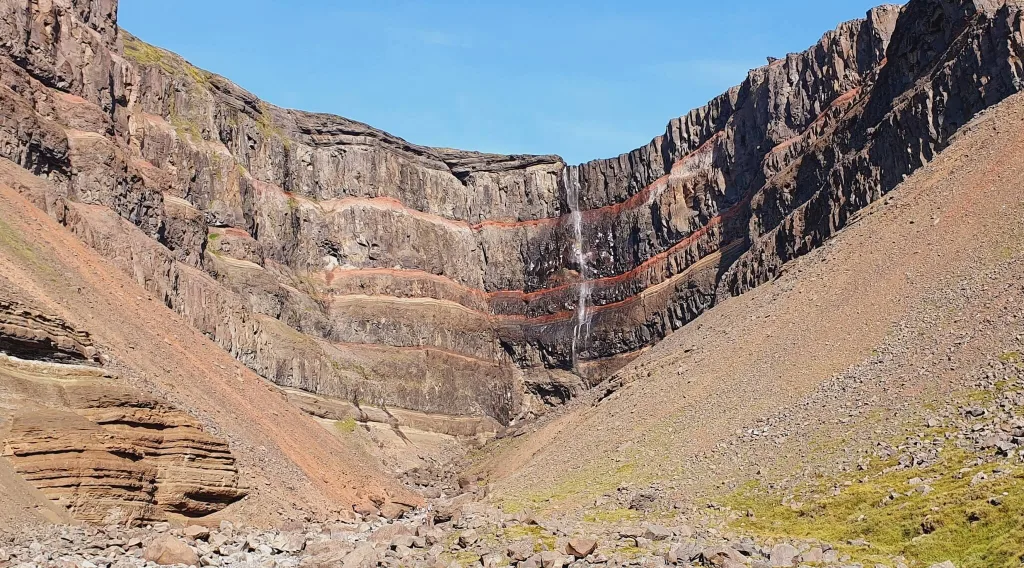
Hengifoss is one of the most touristy waterfalls in Eastern Iceland
Why Go
Hengifoss is surely one of the must-see waterfalls in East Iceland. The only problem is, everybody knows about it already, so you’ll never be alone here.
The waterfall is unique due to its amazingly colored orange veins. It’s also easy to reach by car all year round.
Tip from a Local
- Bring microspikes in winter. The trail to Hengifoss is paved, but it will often get icy anytime between November and March. In summer, it’s a quite easy 45-minute-long, slightly uphill walk.
- Come early or late in the day. Both for fewer crowds and interesting light. Mornings are better for photography, though, due to eastern light.
Our Experience
We’ve been to Hengifoss mostly in summer, and the car park was always almost full of cars. That being said, thanks to a 2.5km (1.5mi) hiking trail, visitors are often scattered around it and not just at one point. Anyway, this is not a hidden spot or quiet spot, be ready for that. It’s still worth a visit in our opinion, because it’s beautiful.
There’s a viewing platform at the end of the hiking trail, and you shouldn’t walk behind it. Many disrespectful tourists do it. Please don’t be a disrespectful tourist. Bring a longer lens, rather than breaking the rules.
Laugarfell
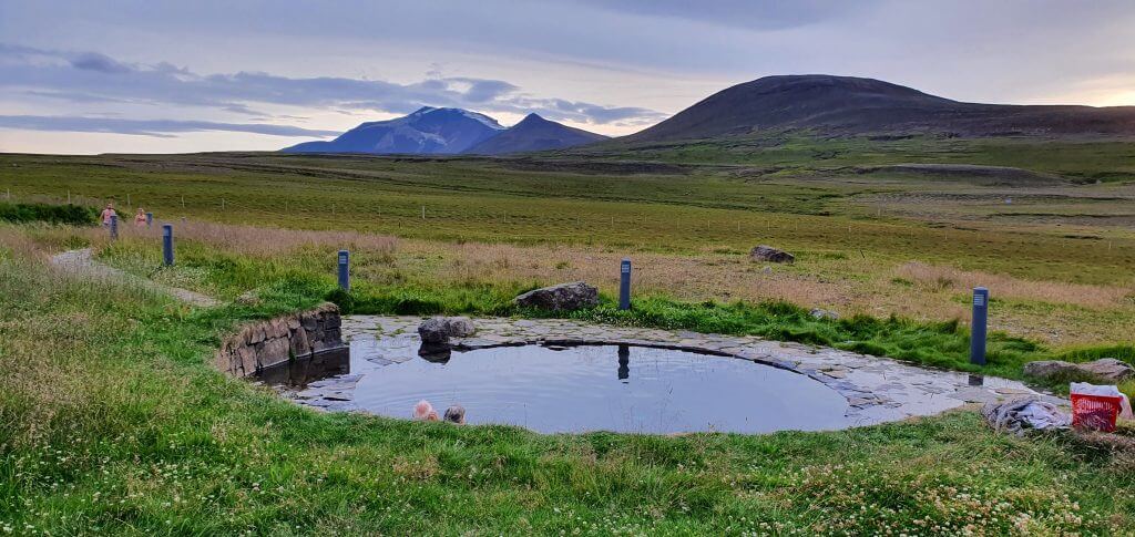
Laugarfell hot spring, an oasis of silence in Eastern Highland of Iceland
Why Go
If you’re looking for a remote yet well-maintained hot spring in scenic surroundings with near-zero visitors, then this is exactly what Laugarfell is.
Laugarfell is a paid hot pool, part of the Laugarfell hut, in the eastern highlands of Iceland. A great place to enjoy a quiet relaxation away from civilization.
Tip from a Local
- Laugarfell is open from June 1st until September 30th. Any car can reach it from the east via Road 910. The road is fully paved all the way to Laugarfell. No 4×4 needed in summer. The north-western access roads are a different story, though.
- Two pools, two temperatures. One sits around 38°C (100°F), the other around 43°C (109°F). The cooler one is where you’ll actually stay. The hot one is for short dips, most people last about 30 seconds.
- Hike the Waterfall Circle from the door. The 8.3km loop past Kirkjufoss, Stuðlafoss and Faxi starts right at the hotel. Do the hike, then soak in the pools afterward. Hard to beat that order.
Our Experience
We ended up in Laugarfell in early September after a super long day of exploration in the Askja area. That’s one of the ways of going about it. You can connect the trip to Askja, Herðubreið, Stuðlagil Canyon, Hafrahvammagljúfur Canyon, or Laugavallalaug hot spring with the visit to Laugarfell.
We saw a few cars in the car park but nobody in the pool. We already took the dip just an hour before in the wild Laugavallalaug, so this time we skipped the soak in Laugarfell.
F959 road
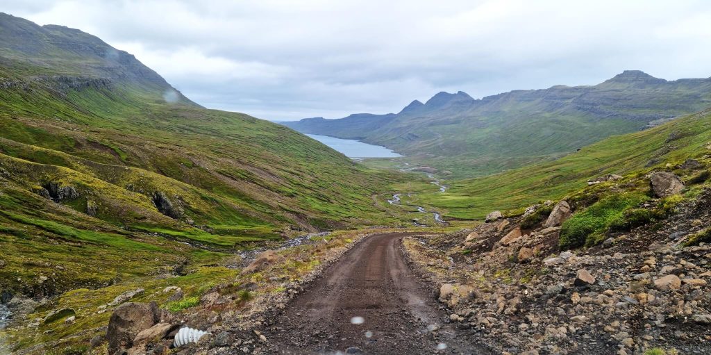
Road F959 is one of the steepest and most scenic highland roads in the Eastfjords
Why Go
F959, or Viðfjarðarvegur if you like, is a steep, bumpy highland road leading to one house in Viðfjörður. Yes, you read it correctly – to one house. Only in Iceland.
When driving F959, you’ll get beautiful views over the fjord and a lot of adrenaline when looking down at the steep drops on your side.
Tip from a Local
- Go only in summer, only with a 4×4 that can handle steep roads, and only if there’s no heavy fog. There are no river crossings on F959, only small streams if it’s wetter.
- Is F959 worth driving? Well, for most of the regular visitors, not really. But if you’re looking for a nice, adventurous remote drive with a peaceful picnic spot at the end, we’re giving you a green light.
Our Experience
We drove F959 in early August and were the only car on the road during that afternoon. We can only confirm that the road is not for the faint of heart. The bumpiest sections are often at spots with the steepest drops. Otherwise, the road is not that difficult, just a bit scary. High ground clearance surely helps. We had a Land Cruiser.
Once we reached the calm Viðfjörður, we saw locals enjoying the summer in this single house at the end of the road. It’s a private property, so please respect that and keep enough distance not to disturb them. We had a short meal pause, enjoyed the scenery, and headed back.
Mjóifjörður
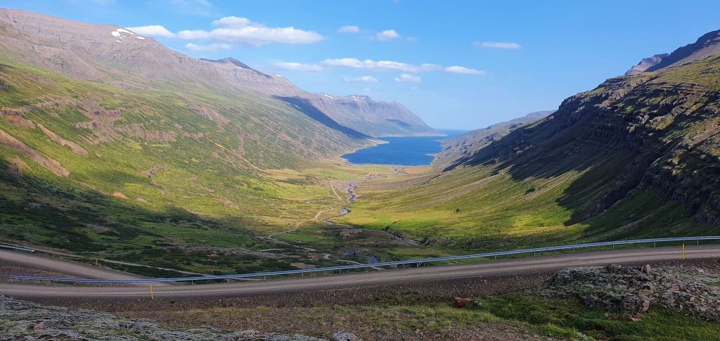
Mjóifjörður is a huge and long fjord with several great stops making it a highlight of East Iceland itineraries
Why Go
Mjóifjörður is definitely one of the most beautiful fjords in the Eastfjords. You can reach it in summer via the beautiful, zig-zagged road 953 winding all the way down to the fjord.
There are several beautiful spots along the road to Mjóifjörður, such as the famous Klifbrekkufossar waterfall, a WWII US Navy ship wreck, or Dalatangi lighthouse at the end of road 953.
Tip from a Local
- Road 953 is impassable in winter due to a lot of snow. In summer, you can drive it in any car. It’s just a bumpy drive, so for more comfort, a higher ground clearance car might help.
- You can spend a night or two in Mjóifjörður. And we recommend it a lot. It’s an amazing place to stay.
Our Experience
We drove Mjóafjarðarvegur on a moody August day in light rain and enjoyed the drive anyway. The road is quite long and versatile, with two main parts. The first one is a twisty road connecting the Ring Road with the fjord, with beautiful views down the valley.
The second one is the coastal drive right next to the fjord itself, with several small settlements along the track. We eventually reached the Dalatangi lighthouse at the end, where we were alone. We once again enjoyed the tranquil atmosphere that Mjóifjörður, as well as many of the other amazing places in East Iceland offer.
Þerribjörg cliffs
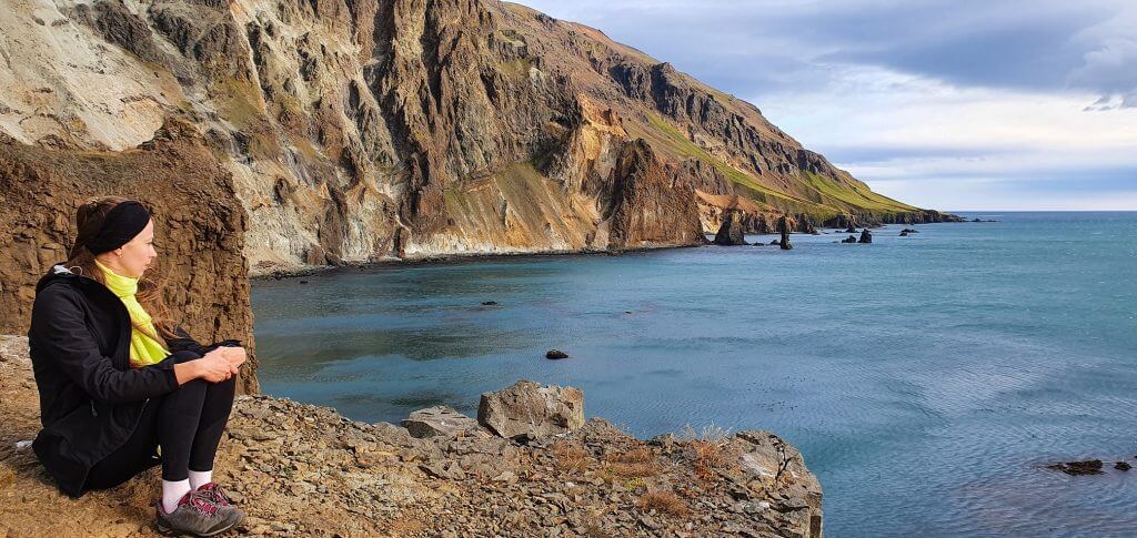
Ker cliff, most often called Þerribjörg cliffs, are one of the best short family hikes in East Iceland
Why Go
Þerribjörg cliffs proudly belong to any list of the top things to see in East Iceland. Yet, barely anyone visits them. The area and the cliffs are sometimes called Ker, so these two are basically interchangeable.
Tip from a Local
- To reach the Þerribjörg cliffs, you have to take an easy 45-minute hike (one-way) along the shore. The “Landsendi” trailhead starts next to road 917, right below the mountain pass, on its southern side.
- Cliffs are situated on the northwestern slope, so any time of the day should be great when it comes to natural light. That being said, mornings and mid-day are better due to the southern light.
- Þerribjörg cliffs are a great family hike as well. Easy and not dangerous, with plenty of stop options.
Our Experience
We hiked to Ker (Þerribjörg) in late August, with the weather being stunning across the north and east – weeks of sunshine with daily highs of 20°C (68°F).
We loved that the path follows the coast, offering sea views, black beaches, and several scenic viewpoints along the way. It isn’t well marked, but a semi-trodden track is visible with a bit of attention.
Stuðlagil canyon
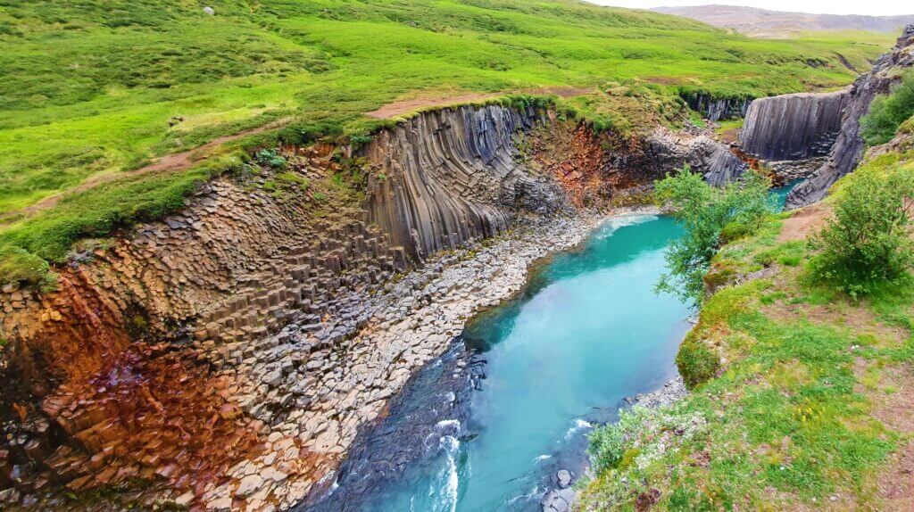
Stuðlagil Canyon, view from the western side
Why Go
Stuðlagil is one of the youngest “famous” spots in East Iceland. Just over 15 years ago you couldn’t even see it – the whole canyon was hidden under a wild glacial river. Then the Kárahnjúkar dam lowered the water, and suddenly Iceland had one of its most photogenic canyons.
What you get now is rows of tall basalt columns, with a turquoise river running between them. It’s no longer a secret, but it’s still well worth the detour.
Tip from a Local
- Pick the right side. The west side is a quick walk to a viewpoint above the canyon, but you can’t get down. The east side is a longer hike (about 5km return) that takes you down among the basalt columns. The famous photos are all from the east side.
- Time it for the blue water. The river is at its brightest blue from spring to early summer. After heavy rain it can turn grey for a few days, so check the weather before committing to the drive.
- Don’t rush past Stuðlafoss. On the east-side trail, about halfway in, there’s a lovely waterfall framed by basalt columns. Most people walk straight by it.
Our Experience
Here we write in detail about our first visit of Studlagil.
We always tell people the same thing about Stuðlagil: do the east side if you have time. The west-side viewpoint is fine for a quick photo, but you don’t really feel the place from up there.
The walk along the river is flat and, to be fair, a bit dull for most of the way. The canyon stays hidden behind the riverbank almost until the end. and then you’re suddenly standing among the columns.
Bring waterproof shoes outside of high summer. The path gets muddy after rain.
Flögufoss waterfall
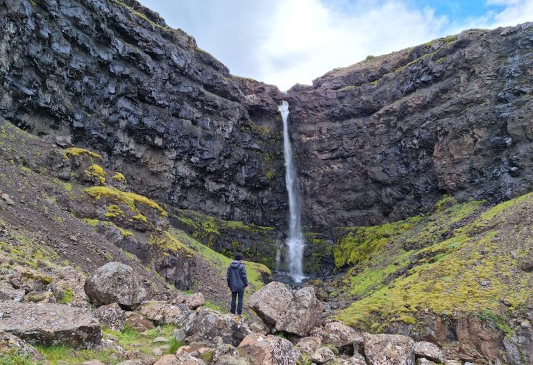
Flögufoss is a little-know, yet well-accessible waterfall we recommend to see in East Iceland
Why Go
Flögufoss is a super interesting and very well accessible waterfall away from the crowds in southeast Iceland near Djúpivogur.
If you are in the area, we surely recommend you go and see Flögufoss. You can park your car on the side of road 966 and then take a very short hike of about 10 minutes to reach the best viewpoint of the waterfall.
Tip from a Local
- Short, but not a flat stroll. Wear shoes with grip. Parts of the trail get slippery when wet. Hiking shoes make the steeper bits a lot easier than trainers.
- Any 2wd car gets you to the trailhead. The road in is fine in summer, and snowy but accessible in winter. No special vehicle needed.
Our Experience
While we met one couple at Flögufoss in August, they were just leaving. This meant we had the waterfall all to ourselves. That’s also one of the main reasons we recommend seeing it.
There’s no paved hiking trail. You’ll have to jump a few boulders to get below the waterfall, so some hiking is needed. Nothing too bad, though.
Vök Baths
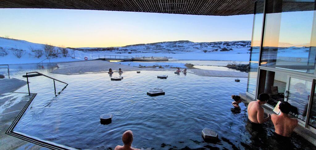
Vök Baths hot spa is for sure the most popular hot lagoon in East Iceland
Why Go
Vök Baths is the perfect place to warm up after a few days of driving and hiking around the East. It sits right on the Urriðavatn lake, only about 5 minutes from Egilsstaðir.
What makes it special are the floating pools – hot pools built straight onto the lake. These are the only floating pools in Iceland. The water is geothermal and clean enough to drink – the only certified drinkable hot spring water in the country.
Tip from a Local
- Do the hot-and-cold routine. Warm up in a pool, drop into the cold lake or the cold mist tunnel, then back to the warm water again.
- Book online in advance via vokbaths.is. Our readers can use the code EPICICELAND for 5% off. There’s also a tea bar (one herbal tea is included) and a bistro with local food if you get hungry.
- Visit in winter too. Vök is open all year. Soaking in a warm pool under a dark winter sky gives you a real chance of catching the northern lights.
Our Experience
We visited Vök Baths in late February on a snowy and windy evening. We barely made it from Seyðisfjörður with our Dacia due to snow patches on the mountain pass. It’s no joke in winter.
The more so we enjoyed the actual soak! The baths were mainly filled with locals and not crowded at all. That’s exactly what we love about Vök – it’s away from typical touristy lagoons.
Öxi road
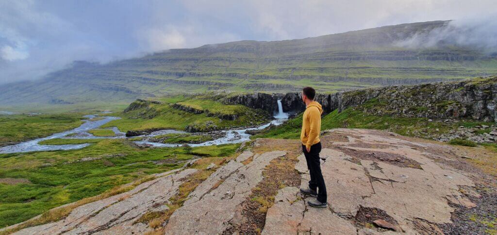
Icelandic crazy Öxi road 939 is a notorious summer shortcut in the southeast Iceland
Why Go
Öxi, or road 939, is a notorious road in East Iceland. It’s beautiful, yet a bit scary for those who didn’t know what to expect. Öxi is the road that some GPS devices recommend as a shortcut from Djúpivogur to Egilsstaðir.
It technically is a shortcut, but it’s a steep mountain track, safely passable only in summer 🙂 The road as such is scenic and we love it. Just bear in mind the steepness and curviness.
Tip from a Local
- If there’s no snow, you don’t need a 4×4 car for Öxi. If there’s snow, I’m not sure I would drive the road even in a 4×4 🙂 Hope this explains it.
- The main alternative to Öxi is to continue southeast via the coastal part of the Ring Road towards Fáskrúðsfjörður and Reyðarfjörður. Longer drive, but beautiful as well. Öxi is the mountain pass, the alternative is a coastal drive. Make your pick.
Our Experience
We’ve driven Öxi several times from both directions. The most beautiful view is if you drive it from the north, heading to the south on a clear day. This way, an entire green valley opens up in front of you. If you want to fully maximize your experience on a sunny day, go early morning or late afternoon. During the day, the sun will shine right into your camera lenses.
We often make two beautiful waterfall stops along Öxi. The first one is the Folaldafoss waterfall and the second one is the Hænubrekkufoss waterfall. There’s a small car park for Folaldafoss, but no place to stop for Hænubrekkufoss, so the only way to see it is to very carefully pull over for a minute.
Bakkagerði (Borgarfjörður Eystri)
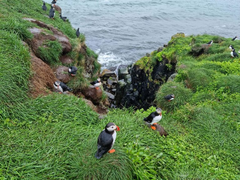
Bakkagerði and Hafnarhólmi are the most visited places in Borgarfjörður eystri and best puffin-watching spots in Eastfjords
Why Go
Bakkagerði, with less than 100 inhabitants, is the only real village in Borgarfjörður Eystri. It’s also the home of one of the largest and easiest-accessible puffin colonies in Iceland in Hafnarhólmi! That’s the main reason people come here.
Bakkagerði is also the base for some of the best hikes in East Iceland, like Stórurð and Brunavík. Puffins, elves, and one of the strangest church paintings in Iceland are a bonus.
Tip from a Local
- Walk up Álfaborg, the “Elf Rock”. An easy path leads to the top, where there’s a view dial pointing out all the surrounding mountains.
- See the puffins at Hafnarhólmi. The little harbor a few kilometers from the village has two viewing platforms where you can watch thousands of puffins up close. They nest here from mid-April until mid-August.
Our Experience
We visited Bakkagerði several times. In summer, the town swells to triple its size due to visitors, but is still nowhere near being crowded. In winter, it almost becomes a ghost town.
The village itself is tiny. You can walk it in 20 minutes. What we like most is that it still feels like a real, living village, not a tourist stop. There’s a small harbor, a couple of cafés, and the kind of quiet that’s getting rare in Iceland.
Waterfall Circle
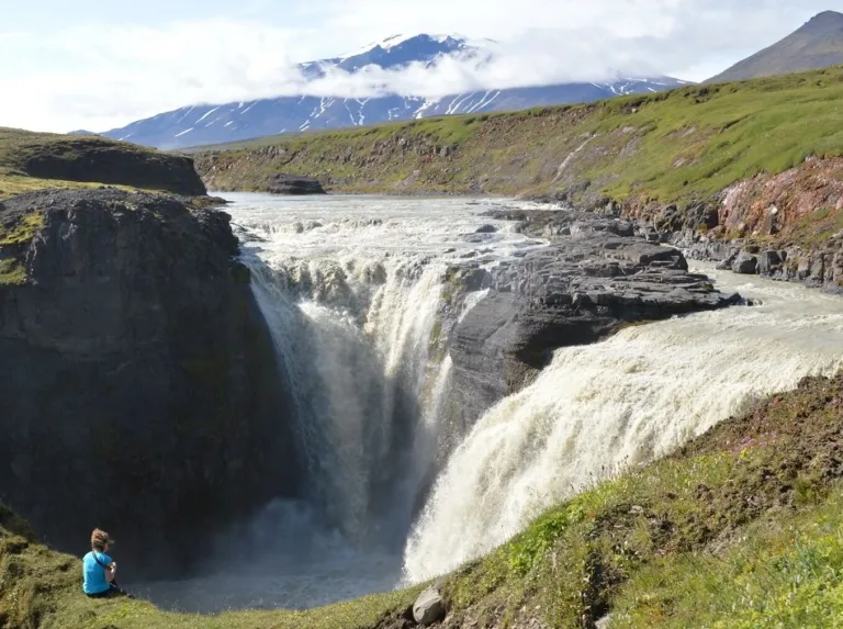
Kirkjufoss, part of the hidden waterfall circle in East Highlands
Why Go
The Waterfall Circle is the best waterfall hike in East Iceland that almost nobody talks about. It’s a loop starting right at the Laugarfell hut, and on the way around you pass more than five waterfalls, a deep canyon, and amazingly beautiful eastern highland scenery.
The three named falls are Stuðlafoss (framed by basalt columns), Faxi (where two rivers meet), and the tall double cascade Kirkjufoss. A few smaller, unnamed ones join in along the way.
Tip from a Local
- Hike it clockwise. The scenery gets better as you go around this way, and you’ll get nicer views of each waterfall. Kirkjufoss near the end is the grand finale.
- It’s an 8.3km loop, moderate, and takes about 2.5 to 3 hours. The trail is mostly easy, but parts are boggy, so waterproof boots are a good idea. There are boardwalks over the wettest sections.
- No drones without a permit. The area is part of Vatnajökull National Park, so drone use is restricted. You’ll have to apply in advance if you really want to fly.
Our Experience
For us, the Waterfall Circle is one of the most underrated hikes in all of East Iceland. Five-plus waterfalls, a canyon, and boardwalks across the highlands, all from a single trailhead, and you’ll likely have the trail almost to yourself.
Kirkjufoss is the circle stop we love the most. Best of all, the Laugarfell hot pools are waiting right where you started. Finish the hike, then soak. Hard to beat that order.
Hafrahvammagljúfur canyon
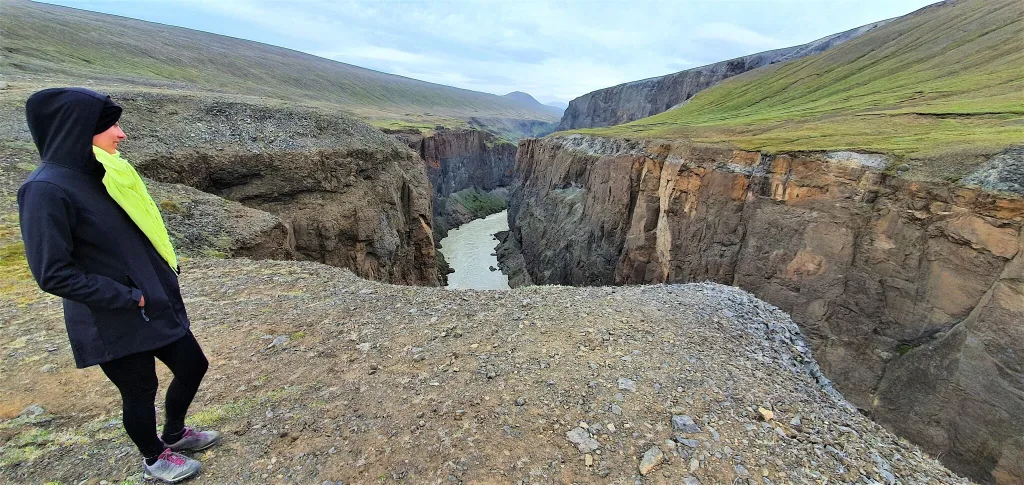
Hafrahvammagljúfur canyon, almost all the time with exactly zero visitors
Why Go
Hafrahvammagljúfur is a majestic canyon hidden in the highlands of East Iceland. Barely any travelers know about it or visit it. Yet, it’s one of the biggest and most monumental canyons in Iceland.
You can either only take a glimpse over Hafrahvammagljúfur from one of the viewpoints – as we did. Alternatively, you can hike along the edge of the canyon, which we plan to do next 🙂
Tip from a Local
- You can reach Hafrahvammagljúfur either from the north via F910 (the harder road) on your way from the Askja/Stuðlagil canyon area or from the southeast via paved road 910 + a short stretch of the bumpy F910 with no river crossings.
- The canyon is a summer-only destination, due to F910 being impassable outside of the June- September window.
Our Experience
We visited Hafrahvammagljúfur canyon on our second trip to the eastern highlands of Iceland. This time we didn’t visit Askja, but rather explored all the roads and hidden spots surrounding Askja.
We came from the north via F88, which was dry and easy at the time of our visit (can be pretty watery as well). We admired Herðubreið volcano, continued south to Stuðlagil canyon, and then wild Laugavallalaug hot spring waterfall. We continued to Hafrahvammagljúfur viewpoints and ended our day at Laugarfell.
We decided not to hike along the canyon, because it would make our exhaustive day even longer. Instead, we stopped at one of the best viewpoints over Hafrahvammagljúfur, which is located right north of the Kárahnjúkar dam. If you are in the area, we recommend you make at least this short stop. Totally worth it!
Klifbrekkufossar waterfall
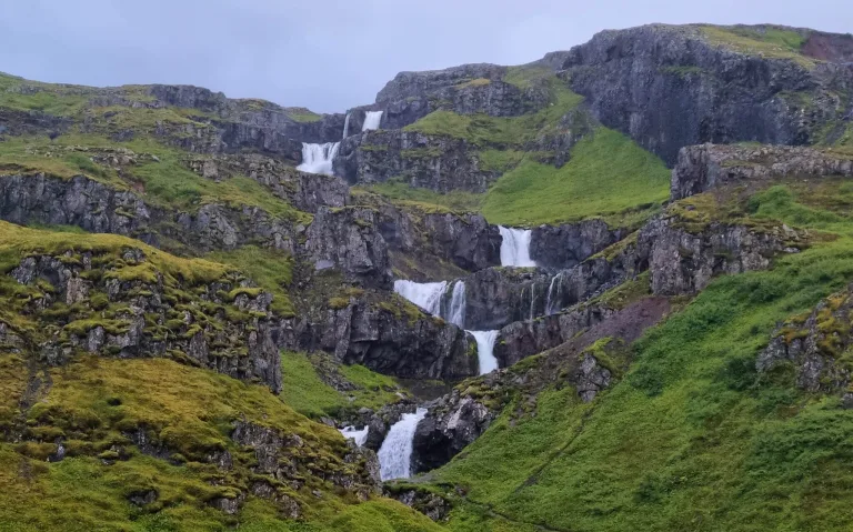
Klifbrekkufosser is a well-known drone-photo spot in the East
Why Go
Klifbrekkufossar is the main photo spot of Mjóifjörður. It’s not a single waterfall but a whole staircase of them. Seven or more cascades stacked right on top of each other on the same river.
The water is spring-fed, so it stays clear and clean all year, which is part of why the falls look so good. And the best part? You barely have to leave your car. The cascade sits right next to the road.
Tip from a Local
- You have two options to see Klifbrekkufossar. Either from your car as you drive down Road 953. Or stop at the little car park at the bottom of the waterfall and hike a bit upwards.
- Most of the famous pictures you’ve probably seen are shot from the drone. You unfortunately can’t see the waterfall in full with a broad perspective by hiking.
- Road 953 into Mjóifjörður is a bit steeper gravel road, open in summer only. Drive it carefully and slowly, especially on the hairpins.
Our Experience
We visited Klifbrekkufossar for the first time in early September during an unusually sunny week. The drive was easy at that time. We stopped at the bottom car park for a short picnic. There are a few tables with chairs exactly for this purpose.
We made a few photos from the foot of the waterfall. However, as I explained above, you can’t see the fall fully from this angle. Then we tried to hike up a bit, but the trail got very steep after a while, so we turned back and rather enjoyed the beautiful day under the waterfall for a while.
Bjólfur viewpoint
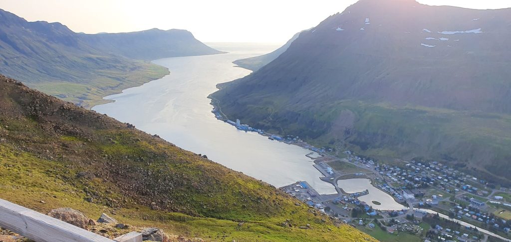
Bjólfur avalanche barriers are by far our favorite viewpoint in East Iceland!
Why Go
Bjólfur is easily the best viewpoint over the amazing Seyðisfjörður. Why? It is the mountain that towers right over Seyðisfjörður, all 1085m of it.
You can’t easily reach the summit of Bjólfur, but a gravel track climbs partway up to the avalanche barriers, and from there you get the top view of the town and fjord there is.
Tip from a Local
- Summer only. The track is usually open from June to September, and closed once the snow comes. Even in summer, fog can sit on top and take the view away, so pick a clear day.
- Drive or hike, your choice. The 5km gravel track from the Fjarðarheiði road gets you up in about 10 minutes by car, but it’s steep and narrow. If that’s not your thing, walk it instead – allow around 1.5 to 2 hours up.
Our Experience
We visited Bjólfur for the first time in August and were gifted a day with great weather. We decided to spend it on Bjólfur and on the Vestdalur hike, which is exactly what we recommend you do as well. At least if you have the guts for Bjólfur.
A quick word on the drive – it’s steep, and there are no railings, so if you’ve got a nervous passenger or you don’t love mountain roads, just hike it. Same view, a bit more sweat.
The barriers themselves are worth a look too. They’re a serious piece of engineering, built to stop snow avalanches from sliding down onto Seyðisfjörður below.
Neskaupstaður
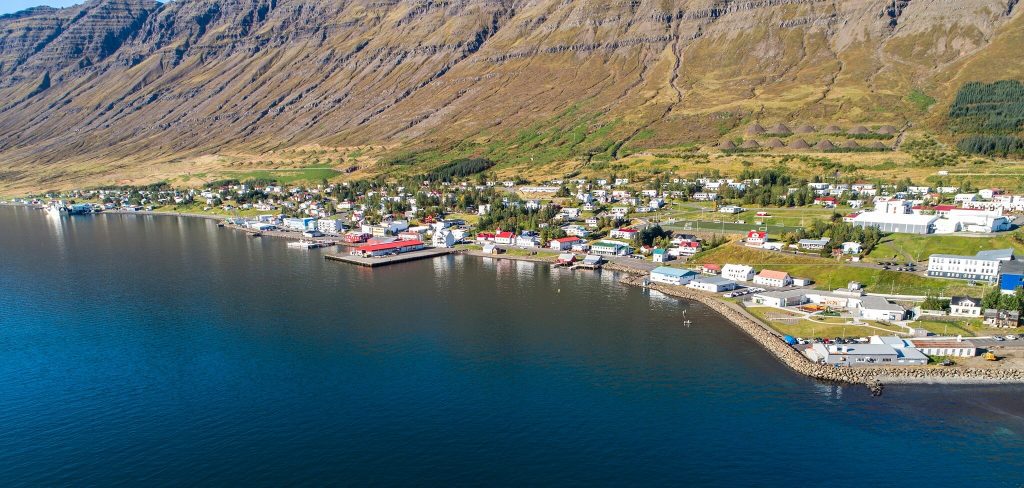
Neskaupstaður is a super quite town in the Eastfjords. Photo by Hlynur Sveinsson is licensed under CC BY 2.0
Why Go
Neskaupstaður is about as far east as you can drive in Iceland. It’s a small fishing town sitting in the Norðfjörður fjord, surrounded by steep mountains on every side.
Neskaupstaður boasts one of the most beautiful coastal boat tours in Iceland, which we highly recommend (10% discount code: EPICICELAND). The tour also visits one of the most beautiful spots of Neskaupstaður – the Páskahellir cave.
Tip from a Local
- Visit Páskahellir, the “Easter Cave”. It’s a small sea cave inside the nature reserve, about a 15-minute walk from the car park followed by some stairs down to the shore. Go at low tide or on a calm day – it’s hard to reach when the sea is rough.
- The drive in is easy. You go through an 8km tunnel on road 92, and any car handles it. If you prefer the scenic, adrenaline-fueled route, the old Oddsskarð mountain pass is definitely more dramatic, but slower.
Our Experience
We’d treat Neskaupstaður as a half-day stop rather than a main destination. It’s a working town first, so don’t expect a long list of big-ticket sights.
Hardly any travelers make it out here, which is a bit of a shame. The main reason to come is the Neskaupstaður Nature Reserve, right on the edge of town. It was the very first nature reserve in Iceland, protected back in 1972.
Vestdalur
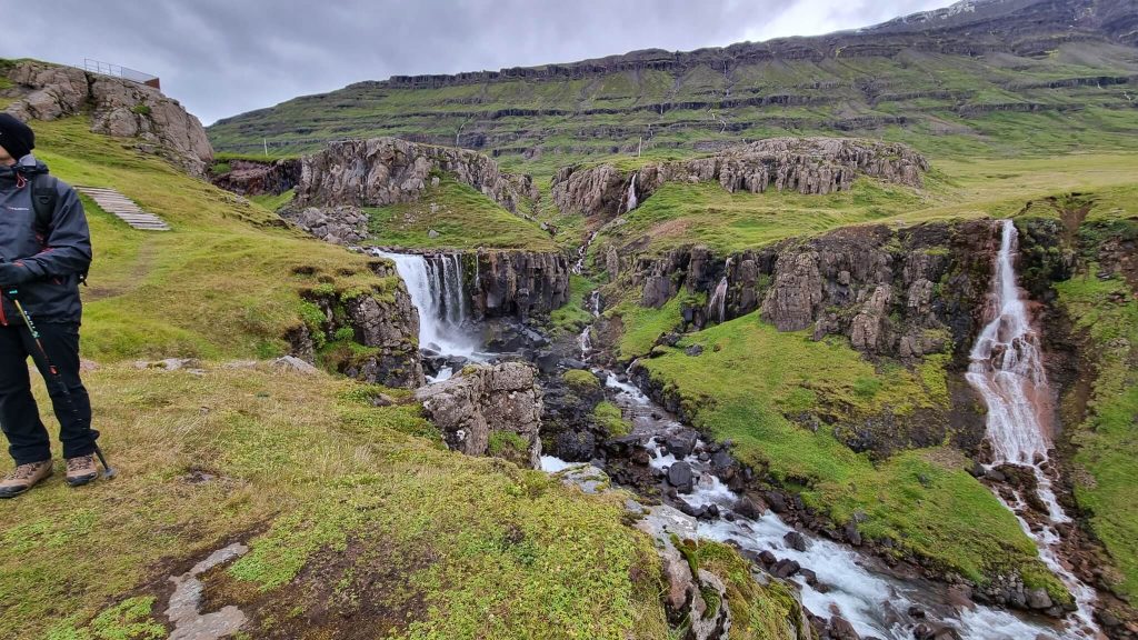
Vestdalur is most likely the best hike from Seyðisfjörður – a “metropolis” of Eastfjords 🙂
Why Go
Vestdalur is one of the most beautiful hikes in the Eastfjords. You can take it directly from Seyðisfjörður.
The trail climbs up behind the town and follows a series of waterfalls into a high valley, all the way up to the little Vestdalsvatn lake.
Tip from a Local
- Pick your length. The shorter walk to the main Vestdalsfossar waterfalls is the easy, rewarding version. The full hike up to Vestdalsvatn is much longer (around 13km) with a serious climb, so plan for most of the day.
- It’s a marked, summer-only trail. The lower waterfalls are fine from late spring to autumn. In winter, the trail gets buried in snow and turns risky. Doable for experienced hikers though.
Our Experience
In summer it’s an easy and very rewarding walk. In winter, it’s a completely different beast – we tried it in early March, ran into deep snow within the first 20 minutes, and turned back. No shame in that. Icelandic winter hikes can get dangerous fast, and turning around is always the right call when the trail disappears.
The full hike up to the lake is still on our list for a proper summer visit.
Vestdalur is exactly the kind of hike that makes Seyðisfjörður worth more than a quick afternoon. The first waterfall shows up just a few minutes from the trailhead, and the trail keeps handing you more of them as you climb.
Fossárdalur
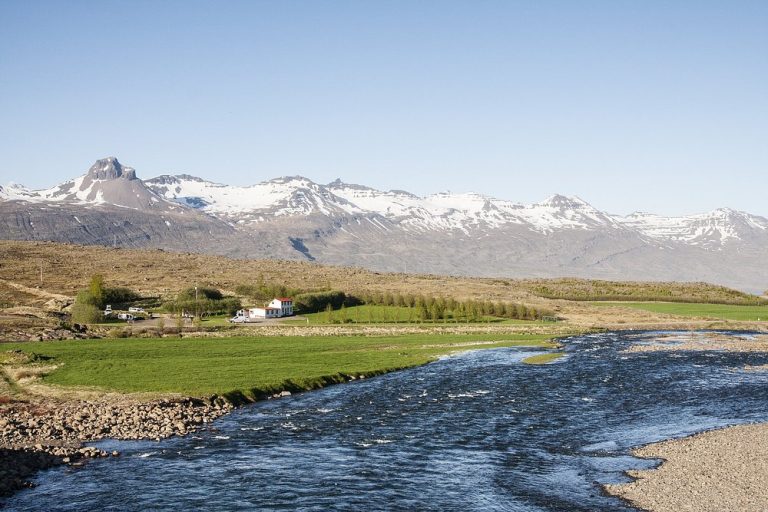
Fossárdalur is one of the most hidden, and yet amazing, campsites in the East. Photo by www.fossardalur.is
Why Go
Fossárdalur is one of the most beautiful and least-known campsites in Iceland. It’s a picturesque valley of waterfalls hidden behind the hills, so you can’t really see it from the Ring Road.
There are four waterfalls, all on the same Fossá river. The first one, Nykurhylsfoss (also called Sveinsstekksfoss), you can see right from the road, so it gets most of the visitors. The other three – Vindásfoss, Sundásfoss and Múlafoss – need a short hike up the valley, and you’ll most likely have them all to yourself.
Tip from a Local
- Make the quick stop even if you skip the hike. Nykurhylsfoss is just off a gravel side road about 15km north of Djúpivogur. Park, walk five minutes, and enjoy the view across the fjord.
- If you are not in a rush, spend the night in the campsite. Fossárdalur is most likely one of the best-rated campsites in Iceland!
Our Experience
Fossárdalur is one of those stops we like to recommend to people who prefer slow travel and spots away from the crowds.
The first waterfall takes ten minutes of your time. The longer hike up the valley adds a couple of hours of very peaceful walking, with hardly anyone else around.
East Iceland Hidden Gems
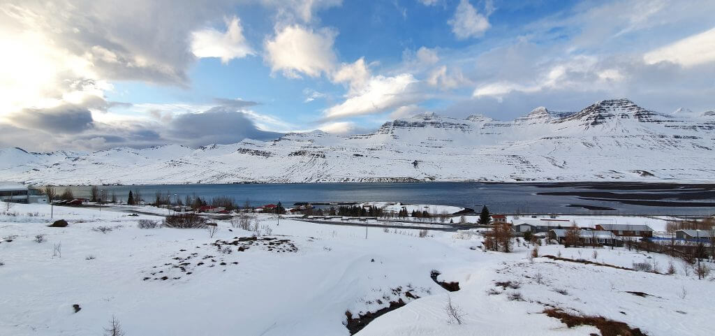
Winter Fáskrúðsfjörður is one of the almost hidden villages of East Iceland
Thanks to the lack of tourists, almost all places in Eastfjords can be considered hidden gems. But not all of them. Here is our list.
Genuinely hidden
- Hikes: Brúnavík beach, a remote beach reached by a 1.5-hour walk from Borgarfjarðarhöfn; Stórurð, a sapphire-blue lake with giant boulders beneath the Dyrfjöll mountains
- Waterfalls: Strútsfoss, for many more beautiful than Hengifoss and almost always empty; Flögufoss, a 10-minute walk from the road and still missed by nearly everyone
- Hot springs: Laugavallalaug, a wild hot waterfall in the eastern highlands; Laugarfell, remote paid pools yet still well accessible by 2wd cars in summer
- Towns: Fáskrúðsfjörður, a quiet fjord village with the best mountain reflections in the East; Neskaupstaður, the easternmost town in Iceland, home to the country’s first nature reserve
- Roads: Öxi (road 939), a steep scenic mountain shortcut most drivers avoid; F946, the most scenic and most remote F-road in the Eastfjords
Not hidden anymore
We would rather be honest than sell you a myth. Three places in East Iceland do draw crowds in summer:
- Seyðisfjörður — the only Eastfjords town where cruise ships dock. Come early in the morning or stay overnight and you will still have it almost to yourself.
- Hengifoss — the car park is nearly always full in summer, although the 2.5 km trail does spread people out.
- Stuðlagil — invisible under a glacial river 15 years ago, now one of the most photographed canyons in Iceland.
If you would rather skip the crowds altogether, there are direct swaps. Strútsfoss gives you the Hengifoss experience without the people, and Hafrahvammagljúfur is a far bigger canyon than Stuðlagil with almost no visitors at all.
East Iceland Highlights Overview
| Place | What it is | Car needed | Season | Cost | Time needed |
|---|---|---|---|---|---|
| 1Fáskrúðsfjörður | Town / fjord | Any car | All year | Free | Half day / overnight |
| 2Brúnavík beach | Hike / beach | Any car | Summer | Free | 3 h return (or 5–6 h loop) |
| 3Strútsfoss waterfall | Waterfall + hike | Any car | Summer | Free | 2–2.5 h return |
| 4Laugavallalaug hot spring | Wild hot spring | 4×4 | July–Sept | Free | 1–2 h on site |
| 5F946 road | Scenic F-road | 4×4 | July–Sept | Free | Half day |
| 6Seyðisfjörður | Town | Any car | All year (winter pass tricky) | Free | 1–2 days |
| 7Stórurð hike | Hike | Any car | Summer (best Aug–Sept) | Free | Half–full day |
| 8Askja | Volcanic crater lake | 4×4 + rivers | July–Sept | Free | Full day |
| 9Hengifoss waterfall | Waterfall + hike | Any car | All year (microspikes Nov–Mar) | Free | 1.5–2 h return |
| 10Laugarfell | Hot pools | Any car (paved Rd 910 from east) | 1 June – 30 Sept | Paid | 1–2 h |
| 11F959 road | Scenic F-road | 4×4, high clearance | Summer only | Free | 2–3 h return |
| 12Mjóifjörður | Fjord + scenic road | Any car (clearance helps) | Summer only | Free | Half day – 2 days |
| 13Þerribjörg cliffs | Sea cliffs + hike | Any car (gravel Rd 917) | May–Oct | Free | 1.5 h return |
| 14Stuðlagil canyon | Basalt canyon | Any car | All year – water bluest early summer | Free | 30 min (west) / 2–3 h (east) |
| 15Flögufoss waterfall | Waterfall | Any 2WD car | All year | Free | 30 min |
| 16Vök Baths | Geothermal spa | Any car | All year | Paid (code EPICICELAND −5%) | 2–3 h |
| 17Öxi road (939) | Mountain pass | Any car if no snow | Summer only | Free | 1 h + waterfall stops |
| 18Bakkagerði (Borgarfjörður Eystri) | Village + puffins | Any car | All year – puffins mid-Apr to mid-Aug | Free | Half day |
| 19Waterfall Circle | Loop hike, 5+ waterfalls | Any car | Summer | Free | 2.5–3 h (8.3 km loop) |
| 20Hafrahvammagljúfur canyon | Canyon | 4×4 (short F910, no fords from SE) | June–Sept | Free | 1–2 h (viewpoints) |
| 21Klifbrekkufossar waterfall | Cascading waterfall | Any car (steeper gravel Rd 953) | Summer only | Free | 15–30 min |
| 22Bjólfur viewpoint | Viewpoint | High clearance – steep, no railings | June–Sept | Free | 30 min by car / 3–4 h on foot |
| 23Neskaupstaður | Town + nature reserve | Any car (tunnel, Rd 92) | All year | Free (boat tour paid, −10% EPICICELAND) | Half day |
| 24Vestdalur | Waterfall hike | Any car (from Seyðisfjörður) | Summer only | Free | 2 h (falls) / full day (13 km to lake) |
| 25Fossárdalur | Waterfall valley + campsite | Any car | All year / summer for valley hike | Free (campsite paid) | 10 min – 2 h+ |
Any car = ordinary 2WD rental in summer conditions ·
4×4 = 4×4 compulsory, no or only minor river crossings ·
Large 4×4 = big 4×4 and unbridged rivers.
Always check road conditions and the
weather forecast before you go.
East Iceland FAQ
Is East Iceland worth visiting?
East Iceland is worth visiting, especially if you want to avoid crowds. The region gets a fraction of the visitors that the South Coast and the Golden Circle get, but it has waterfalls, hot springs, day hikes and tiny coastal towns that are just as good.
The catch is distance. It’s the farthest region from Reykjavík, so it needs proper planning. We’d just say this: if you’re driving the Ring Road, don’t rush through the East in a single day like most people do.
How many days do you need in East Iceland?
One to two days is the practical minimum for East Iceland, and three to five days is better. With two days you can see Seydisfjordur, Hengifoss, Studlagil canyon and fit in one longer hike.
With five days, you can add Borgarfjordur Eystri and its hiking trails, remote fjords like Mjoifjordur, and the highland spots around Laugarfell. We always plan one spare day for bad weather, and we’ve needed it more often than not.
When is the best time to visit East Iceland?
The best time to visit East Iceland is July to early September. That’s when the mountain roads and F-roads are open, the hiking trails are clear of snow, and the daylight hours are long.
Winter is beautiful too, but much of this list simply isn’t reachable. F-roads, mountain passes and most highland spots are closed. In winter in the East, we stick to the Ring Road, Seydisfjordur, Hengifoss, Vok Baths and other similar well-accessible places.
Do I need a 4×4 in East Iceland?
You don’t need a 4×4 for most of East Iceland. The Ring Road and the roads to Seydisfjordur, Hengifoss, Studlagil, Vok Baths and the coastal towns are paved and fine in any car in summer.
A 4×4 is needed for the F-roads (F946, F959), for Askja and Laugavallalaug, and for the drive up to the Bjolfur viewpoint. For those roads, our advice is simple – the bigger the car, the better.
What are the real hidden gems in East Iceland?
Our picks for the real hidden gems in East Iceland are Strutsfoss waterfall, the Therribjorg (Ker) cliffs, the Waterfall Circle hike at Laugarfell, Fossardalur valley and Flogufoss. All of them are beautiful, and at all of them you’ll likely be completely alone.
We’d also add Faskrudsfjordur to that list. It’s not a “sight” as such, just a wonderfully calm little town that almost no one writes about.
Where should I stay in East Iceland?
Egilsstaðir is the most practical base in East Iceland. It’s the largest town in the region, with shops, fuel and restaurants, and it’s within easy reach of Hengifoss, Studlagil, Vok Baths and Seydisfjordur.
For a nicer experience, we’d pick a smaller fjord town instead. Seydisfjordur for atmosphere and good food, Faskrudsfjordur for quiet and fjord views, Bakkagerdi if you came here to hike.
Can you see puffins in East Iceland?
You can see puffins in East Iceland at Hafnarholmi near Bakkagerdi, from mid-April to mid-August. The site has purpose-built viewing platforms where you can watch the birds from just a couple of meters away, which makes it one of the best puffin spots in the country.
Outside that window the puffins are out at sea, so there’s no point planning around it. Late April to July is when we’ve had the best luck.
Can you see the northern lights in East Iceland?
You can see the northern lights in East Iceland between roughly September and March. There’s very little light pollution once you leave the towns, so on a clear, dark night the chances are good.
Summer nights are far too bright for aurora, so don’t count on it from May to August. Our favourite way to wait for them is from a warm pool at Vok Baths under a winter sky.
Are there hot springs in East Iceland?
There are several hot springs in East Iceland, covering the full range. Vok Baths is the polished one with floating pools on a lake, Laugarfell is a simple pair of well-maintained hot pools in the highlands, and Laugavallalaug is the wild one with its own hot waterfall.
Vok is reachable year-round in any car. Laugarfell and Laugavallalaug are summer-only, and Laugavallalaug needs a 4×4. Laugavallalaug is our favourite of the three, but it’s also the hardest to get to.
How do you get to East Iceland?
Most people reach East Iceland by car. From Reykjavík it’s roughly 650km in either direction around the Ring Road, which is a full day of driving, or better, two.
You can also fly from Reykjavík domestic airport to Egilsstaðir in about an hour and rent a car there. If you’re arriving by ferry from Denmark or the Faroe Islands, you’ll land directly in Seydisfjordur.
What’s the weather like in East Iceland?
East Iceland often has better weather than the south of the country. In summer, the East regularly gets the sunniest and warmest conditions in Iceland, sometimes with several dry weeks in a row.
It’s still Iceland, though. Fog rolls into the fjords fast, and mountain road conditions can change within an hour. We always check en.vedur.is and road.is before any big driving or hiking day.






This is wonderful information! Thank you! Planning a trip for next year.