Ever relied on Google Maps? Never? You probably lie. We live in a world where we simply got used to Google Maps taking us anywhere we want without any need to use a classical old-fashioned map. So will you be fine using just Google Maps in Iceland? It turns out that, in most of the cases, yes.
How do Google Maps work in Iceland?
Google maps work pretty well in Iceland. I’ve read articles stating that you shouldn’t rely on Google maps in Iceland – both in terms of maps precision and estimated times. Neither of those is true, however. I found Google maps really useful and precise and could almost always rely on their precision and estimated times.
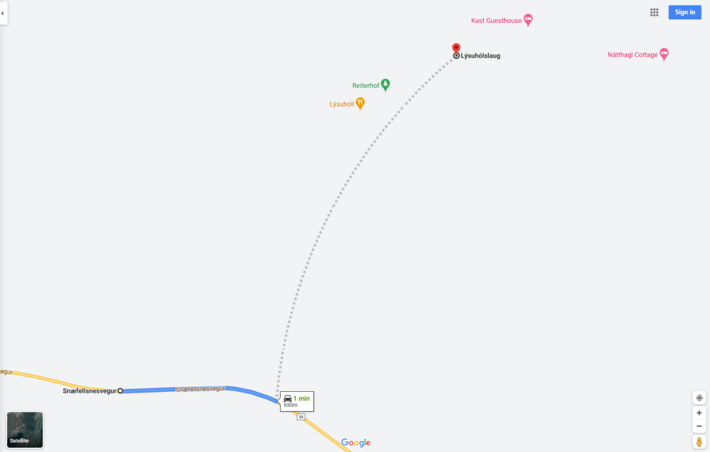
Lýsuhólslaug hot spring as indicated on Google Maps. The road to it does exist, though.
When it comes to road tracking precision, just once during our trip Google couldn’t recognize a road we were driving on. It was a short part of the road of the length of a few hundreds of meters heading to a hot spring spot in Snæfellsnes peninsula (Lýsuhólslaug). Other than that, all kinds of road, including F-roads and even some no-name roads were covered well.
You don’t even need a working internet, because you may download the maps in offline mode at home and just use them after arrival. Even though we had a free wi-fi included in our car rental (and our smartphones with a European internet coverage) there were often times when our trip led us to areas without any internet or any cell phone network coverage. So definitely download the maps in offline mode, you will use them!
What about F-roads vs. Google Maps?
In terms of precision of the estimated times, again I’ve read a lot of articles saying that times stated on Google maps especially on F-roads are underestimated and you should prepare for longer driving than suggested by Google. And I again disagree. For us, ON AVERAGE, the route estimates by Google were correct. It all depends on your driving skills though. There were times when I was much quicker compared to Google maps estimates and vice versa, there were times when we were a bit slower. However, I consider myself a faster driver and we’ve encountered many drivers driving much more slowly and carefully than me and, in this case, naturally, your journey will take longer.
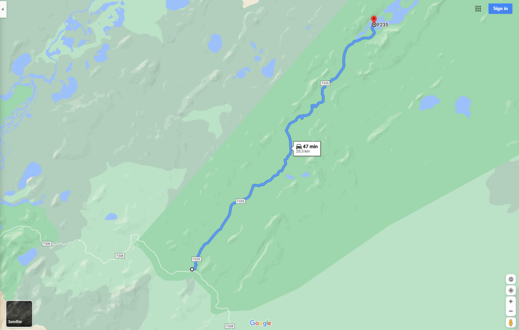
F235 towards Langisjór as indicated on Google Maps
An important note one may forget about – the time estimates are without stops or photo-pauses! Definitely count on them when making an itinerary, you will be doing a lot of them.
You won’t find river crossings on Google Maps
An important thing to consider when planning Icelandic trips are river crossings. River crossings may affect your trip plans considerably. So plan precisely and in advance.
Where to find river crossings then, if not on Google Maps? You can find info about most of the river crossings in our list of F-roads and really specific details about each river crossing we’ve done in our journey diary.
Google maps time estimates on F-roads
Google maps are pretty much quite precise in time estimates, even when it comes to F-roads. This means if you are planning your trip, you may more or less rely on Google time estimates. There are a few caveats though.
Google maps time estimate is an estimate under standard conditions. This usually assumes, for example, normal weather, crossing the rivers immediately, etc. So what are the other things you need to account for other than standard conditions?
- Worse weather. This means anything from heavy rain, through a huge fog, to strong wind. Incorporate these into your estimates.
- Proper car. You need to drive a 4×4 car on all F-roads. However, 2 different 4×4 cars may be as different as night and day.
- Your driving skills. I’ve seen many much slower drivers when driving in Iceland. But I’ve also seen some much quicker. I would say I’m somewhere in the middle then, and I aligned with Google times quite well.
- River crossings. If you don’t know the river you are crossing, or if you are just inexperienced, you should take enough time to examine the river.
- Tourists. Yes, in high season there may even be a traffic jam on some F-roads. This may slow you down. Or maybe you will be the cause of the traffic jam? 🙂
- Pauses. You’re gonna make MANY of them. To eat, to take a picture, to go use the toilet, etc. Calculate with these as well.
Are Icelandic hiking trails marked in Google Maps?
As you would probably guess, in the majority of cases, the answer is negative. When it comes to hiking trails, you basically have these 3 options:
- Try to Google them somewhere on the internet (success rate <50%) or use a blog like this
- Buy a map once you come to Iceland or your place of interest. There may or may not be the map that you need though
- Don’t search or buy anything. Come and improvise. Well, this one doesn’t go along with planning much.
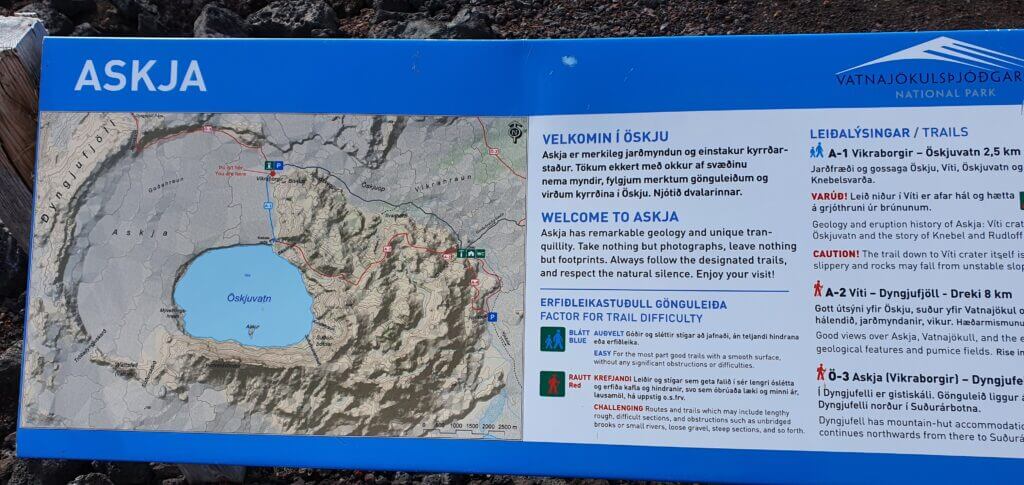
Askja area hiking map


Hey, NO, there are absolutely more choices than just Google, paper or NO maps when it comes to hiking!
Please, be responsible and use a proper app with hiking trails, so you don’t get lost or stuck! This is true for Iceland or any other part of wilderness anywhere.
Some of the best apps for trails are:
– Locus Map with LoMaps — very good and reliable maps based on Open Street Maps, but improved. Very good value in this app.
– AllTrails
– Outdooractive
– Bergfex
– Komoot
These all provide some version of their own maps based on OSM and they are much, MUCH better than anything google maps provides. All these maps also provide offline maps download — since there is probably no cellphone coverage where you will be hiking. These apps also provide other features, like tracking, height profile, planning and a lot of that offline, if you are willing to pay something for your safety and responsible plannig.
Another note on other apps for Offroad and 4×4 driving:
Google maps is not the only app to be used here either.
– Gaia maps — beloved and the staple of any serious 4×4 adventurer
– maps.me — for simplest vector maps offline and very well updated POI
– iOverlander — for community generated POI, esp about camping spots
– AlpineQuest — for offline access to sat images
Expect better, more precise content from these apps regarding 4×4 driving, more features and all this offline.
Another trick which many people don’t know is that you can also download maps and guidance on Google Maps.
Hi Danijel, thank you for your valuable feedback! This is one of our oldest posts, we should definitely update it! 🙂 Thanks for some very good ideas! We’ve already covered some of those in our newer article about Icelandic Roads: https://epiciceland.net/icelandic-road-system/#Free_maps_of_Icelandic_roads but your points are even more comprehensive when it comes to hiking, so we will definitely incorporate that and give you a credit for the tips.
I can recommend Komoot for hiking/biking, verry detailed, the smallest hiking tracks are there. Of every track there’s
information about the type of track (road/gravel/dirt/alpine/etc and the slopes of climbs. You can make a route, navigate, see pictures of highlights and you can download hikes for offline use.