Contents
Landmannalaugar hikes
There are two main, most beautiful, one-day hikes you can do from the Brennisteinsalda campsite. And it can be a bit confusing to understand the difference between them and how to get to each trail. At least for me, it was in the beginning. So let’s get to the point.
First of the hikes, the easier and quicker one, is the hike ending at the top of the Brennisteinsalda volcano, or “orange mountain”. It takes about an hour to reach the top and some 30 minutes to come back. The ascent is of normal difficulty and everyone should be able to make it.
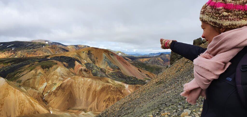
Pointing at Brennisteinsalda from Bláhnjúkur hiking trail
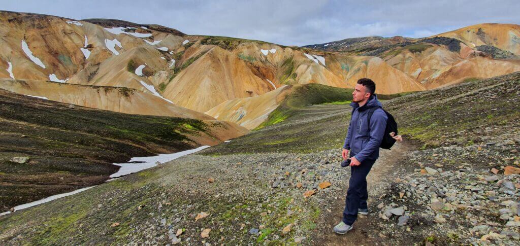
The second hike, for me even more beautiful, is the hike to the Bláhnjúkur peak or “Blue peak”. It’s a bit longer hike, it took us 1,5 hour to get to the top and some 1 hour to get back to the campsite and you should be in good physical condition to make it, at least compared to other places in Iceland where you just step out of your car and make a 5-minute walk. But it’s definitely doable for everybody and more than just worth it as it’s one of the most beautiful views in entire Iceland. Just be prepared for a mountain hike.
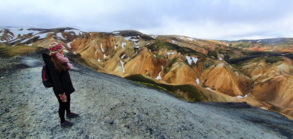
View from the top of Brennisteinsalda towards Bláhnjúkur
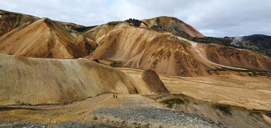
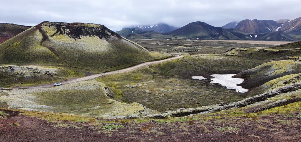
What helped me the most with orientation was this map. I wonder why it’s so hard to find this map online, but this map is basically all you need to know. If you are in a good physical condition and weather is good, I definitely do recommend you to go for both peaks – Brennisteinsalda and Bláhnjúkur as well. It’s a beautiful loop trail, so you don’t go twice via same trail and all the views around it are breath-taking. On a halfway to Brennisteinsalda you’re going to cross lava field called Laugahraun which is interesting as well, although compared to the other peaks it’s not that special.
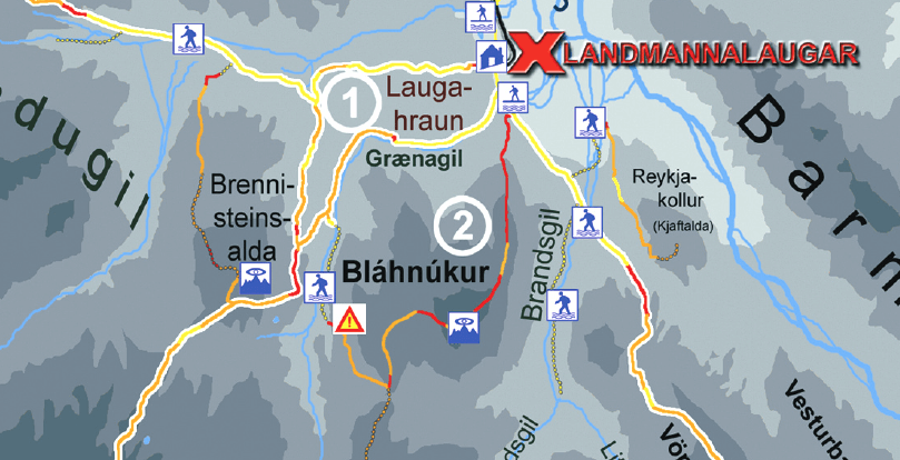
The most important slice of Landmannalaugar map for your 1 day trip
There are of course many other trails in the Landmannalaugar area. If you are really into hiking or if you’re planning to spend more days in the area, you’re more than welcome to go for the other trails as well. The longest one is supposed to take some 3-4 days and ends in Thórsmörk, another magnificent valley. You will be probably spending nights in mountain huts along the way if you choose this hike. We didn’t go for it, as we wanted to see as many different parts of Iceland in possible in 12 days, but next time – why not? Just be prepared for rough cold weather even in summer and its sudden changes.
Brennisteinsalda hike
9:00-10:30
Distance from car park: 5/10 minutes (to the start of the trail, from camping/car park in front of the camping)
Time spent at: 1 hour to the top
Worth visiting even with bad weather: no
Physical condition needed: medium
Interesting index: 1 – amazing  (1-amazing, 2-great, 3-nice)
This is how the start of the hiking trail towards Brennisteinsalda looks like
Hike for Brennisteinsalda volcano is quite easy and takes around 1,5 hour round trip. If you either don’t have much time, or weather is worsening or you simply aren’t into hiking that much, you can definitely make this one. The trail to the top and the view from the top itself are definitely worth it. We experienced it in slightly foggy weather and it was still beautiful.
Easy Brennisteinsalda hiking trail
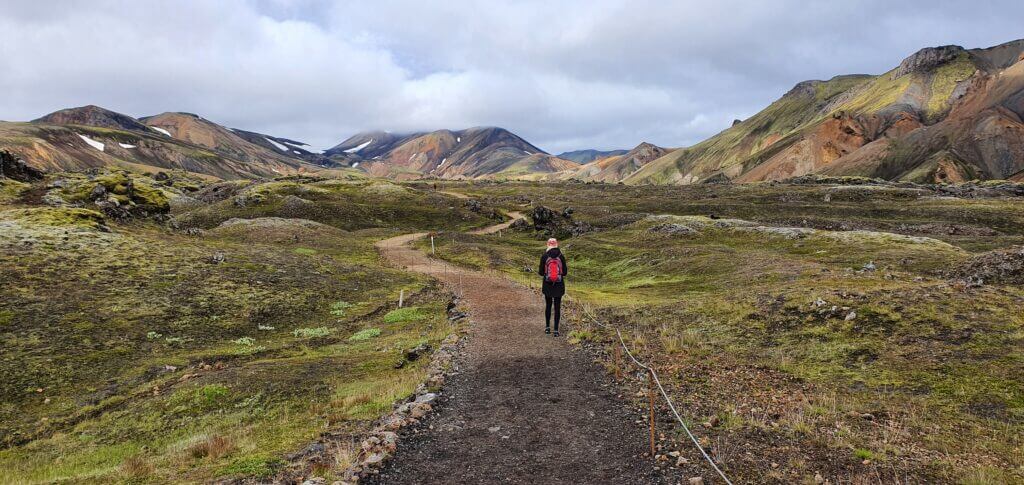
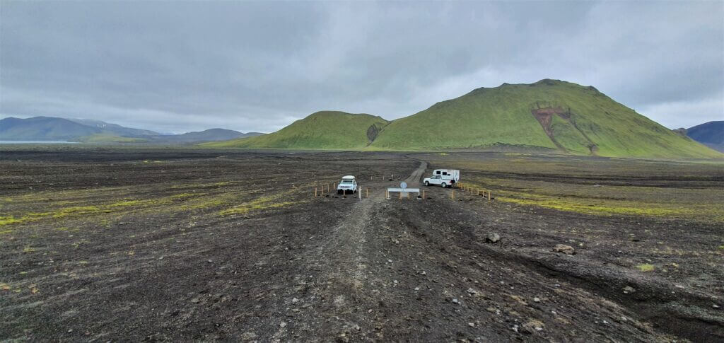
You start at the main building of Landmannalaugar/Brennisteinsalda campsite where there are red signs pointing to two opposite directions. When coming from the river crossings facing the campsite, the one pointing left is the one for Bláhnjúkur and the one facing right is the one for Laugahraun lava field and Brennisteinsalda. The other way how to orientate yourself is simply to go in the direction of the mountain (you can see it throughout almost the entire trail) and use common sense.
Although the trail is well marked, the signs are not very helpful because they contain just the name of the entire trail and they don’t point specifically to Brennisteinsalda. It’s important to stick to the marked trail to not destroy Icelandic untouched nature and not get yourself fined heavily.
Views from the Brennisteinsalda hike
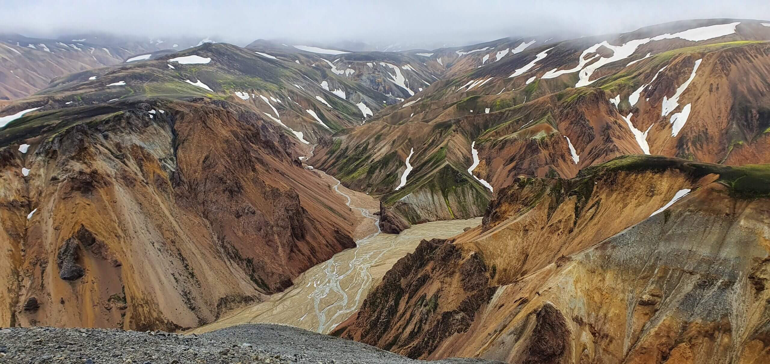
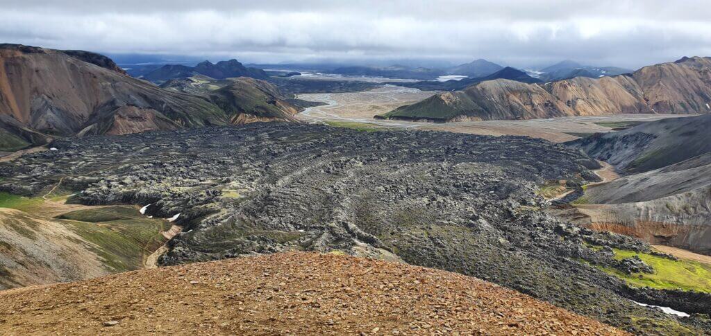
Your first checkpoint would be crossroads with Laugahraun lava field where you will continue to the upper right, i.e. above the field. Then you will eventually arrive at another crossroad just below Brennisteinsalda where you should turn right, to face the only little steeper part of the hike right towards the peak. Once you reach the peak, you can enjoy 360° views of surrounding landscapes, Laugahraun field from bird-eye view and also majestic Bláhnjúkur peak nearby.
View from the top of Brennisteinsalda on a slightly foggy day. Still very windy at the top, despite calm day.
There was no wind below Brennisteinsalda at the time of our visit, but at the peak wind was blowing like crazy. So be prepared for this. After Brennisteinsalda you may either come back to the campsite or continue for the Bláhnjúkur peak – as we did. If you have enough energy and the weather is alright I definitely do recommend to go for Bláhnjúkur as well as the views surrounding that route are even more amazing.
Laugahraun
11:00-11:10
Distance from car park: 5/10 minutes (to the start of the trail, from camping/car park in front of the camping)
Time spent at: 15-20 minutes
Worth visiting even with bad weather: yes
Physical condition needed: little
Interesting index: 3 – nice  (1-amazing, 2-great, 3-nice)
View from the top of Brennisteinsalda towards Laugahraun
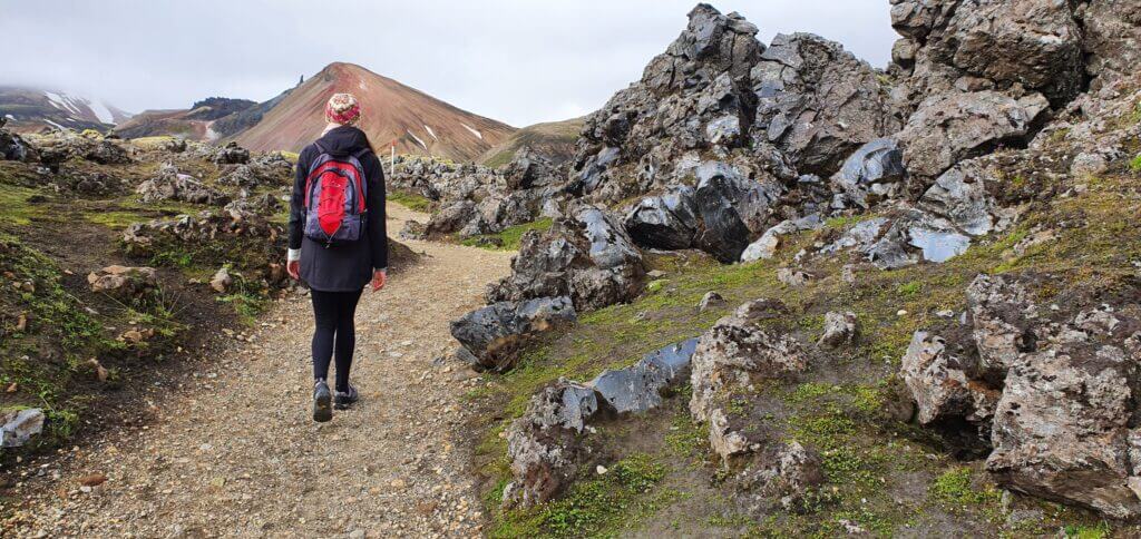
Laugahraun is a lava field with interesting rock formations formed from volcanic lava eruptions. It takes some 30-40 minutes to reach it from the campsite and it stands on the halfway to Brennisteinsalda mountain. It’s a nice place to see but it was not that amazing for us compared to other sights like peaks of Bláhnjúkur or Brennisteinsalda. We didn’t go particularly for it, but we stumbled upon it on our way back from Brennisteinsalda peak and on our path further towards Bláhnjúkur mountain.

If you have enough energy and good weather I recommend you to take the same route as we did so that you can admire all of them. Coming from Brennisteinsalda, if you leave the Laugahraun field at its top-right part, you will find yourself at the beginning of the trail for Bláhnjúkur , the Blue peak.
Bláhnjukúr hike
11:15-13:45
Distance from car park: 15 or 40 minutes (if you want to go only for Blahnjukur or if you firstly want to go for Laugahraun lava field)
Time spent at: 2 hours to the top, 60-90 minutes back down
Worth visiting even with bad weather: no
Physical condition needed: advanced
Interesting index: 1 – amazing  (1-amazing, 2-great, 3-nice)
Slippery clay slope at the start of the hike to Bláhnjúkur or Blue peak
For us hike to Bláhnjúkur, or the Blue peak, was the most beautiful, the most rewarding and the most difficult part of our one day visit of Landmannalaugar. We had to find the beginning of the trail, we had to ford the small river, we had to climb the steep muddy hill and then we had to cope with a strong cold wind at the top. All of these were definitely worth the experience. Views encompassing the route are amazing if you are lucky with the good weather. View from the peak is even more breath-taking. So how do you reach Bláhnjúkur?

You have three options to reach the top (including circular round trip we did, starting with Brennisteinsalda and continuing to Bláhnjúkur or vice versa). Arriving from river crossings before Landmannalaugar you may:
- either turn left and go directly for Bláhnjúkur or
- you may turn right, reach the Laugahraun lava field first and then continue for Bláhnjúkur hike or
- of course, you may choose the order we chose, i.e. after reaching Laugahraun continue for Brennisteinsalda peak, then come back to Laugahraun and then go for Bláhnjúkur.
I recommend the way we did it, i.e. go for the circular route, so that you can see everything.
Spectacular views right from the beginning of the hike on Bláhnjúkur and even on the slightly foggy day
After you leave the upper right part of Laugahraun field (coming from Brennisteinsalda trail), you will arrive at the small river. Despite the river being small, there’s no bridge or a designated place where the river should be crossed. We spent almost 30 minutes searching for the spot where to cross the river to not get our feet wet in this cold weather. And up to this day, I don’t know where was the “official” spot meant for this river to be crossed.
What we finally did was going almost 10 minutes to the right along the bank of the river coming to the place where the river was shallow enough with enough pebbles to jump on and pass. Then we had to come these 10 minutes on the other side of the river back again to reach the yellow marks marking the trail towards Bláhnjúkur. So, after 30 minutes of struggle, we managed to ford the river without getting wet, although I’m not sure whether this was the way meant for crossing, probably no.
Bláhnjúkur hike near the top
Afterwards, for us, the most dangerous part followed. A trail is well marked with yellow sticks so you shouldn’t get lost. You will shortly arrive at the steep clay slope going up closer towards Bláhnjúkur. The ascent is not hard or anything, but it’s quite steep and you don’t have a good grip on the ground because of the clay. So with each step, you feel like slipping on the smooth clay. I was equipped with high-quality La Sportiva hiking shoes and those didn’t help either. There are neither stairs nor chains so you can only help yourself by going slowly zig-zag to the top.
Fortunately, this part is not too long and takes some 10 minutes to complete. What follows next is just a typical gravel hiking trail and you shouldn’t have any problems continuing up the path. Magnificent views will shortly emerge and will accompany you all the way to the top.
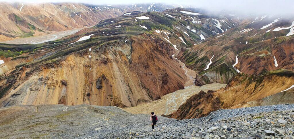
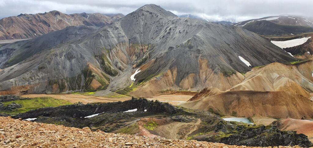
One of the views from the peak of Bláhnjúkur towards Landmannalaugar and 2nd (steeper) hiking trail
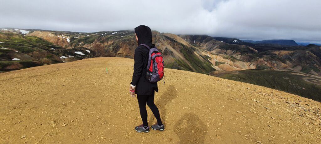
We had a semi-clear sky with partially sunny, partially cloudy weather and light fog. This is still supposed to be good weather so we enjoyed every moment of it. Visibility (although not perfect) was fine and the views were, as I already mentioned, breath-taking. We met only a single-digit number of visitors at the peak, so at the time of our visit, peak being crowdy wasn’t an issue. It was really windy and temperature felt like 5°C even on the sunny summer day like ours, so be prepared for that. Once reaching the top, you will be rewarded with the best views over the area.
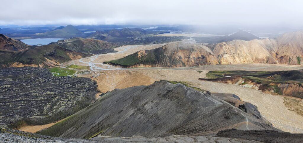
Another view from the peak of Bláhnjúkur towards Landmannalaugar camp, Laugahraun and 2nd (steeper) hiking trail
We started our descent from the other side of the mountain (the one where you may access Bláhnjúkur right from the campsite), which was supposed to be much steeper, according to guides I’ve read. That definitely wasn’t true and compared to the steep clay part we had to overcome before, this was a piece of cake. I wonder what’s worse – to ascent the clay part or descent? I guess descent would be worse.
The trail continued without any obstacles until we reached the point where we could see the small river we’d forded before from above. At this point we’d also seen the campsite from above already, so we continued pursuing that direction. The entire descent wasn’t hard and it took us some 1 hour at maximum to reach our campsite again. We went for a hot chocolate at the nearby snack bar and ate a little. It was still only before 3 pm so we had enough time to continue with our journey.
F208 north towards Sigöldugljufur canyon
15:00-15:30
Worth visiting even with bad weather: yes
Interesting index: 3 – nice  (1-amazing, 2-great, 3-nice)
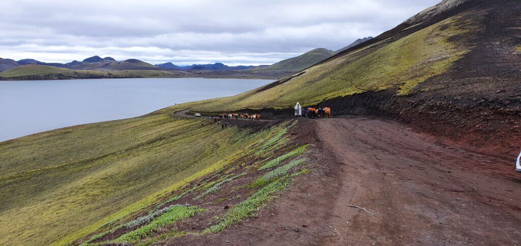
Horses or “Icelandic ponies” blocking the F208 road Fjallabaksleið Nyrðri north of Landmannalaugar
This is the F208 all of the guidebooks out here suggest you use if you want to go for Landmannalaugar. Well, if you are afraid of, or if you simply don’t want to cross rivers, then yes, this is the right way to arrive and leave Landmannalaugar as well. All the other ways like F208 to the south, F233 and F210 towards Maelifell or Landmannaleið – the shortcut in/out of Landmannalaugar, all contain some serious river crossings.
The beginning of the road near Landmannalaugar, until Ljótipollur detour, is very beautiful. Afterwards, the road shortly turns into a dull gravel road. Hence, the majority of the road is just a normal gravel road with potholes without any nice views alongside it. Compared to the out of this world, amazing F208 to the south there isn’t much to see.
F-road towards Ljótipollur
But the views you see from this road are not the reason why people like us use it. Apart from not going back down the same road to the Vik, there lie two very nice stops along the road. Namely, two beautiful canyons entirely different in appearance, both definitely worth visiting. These were among the most beautiful places we’ve seen.
The northern part of F208 is actually definitely doable also by 2wd car, it would just be a really bumpy ride. That’s what I meant by saying “it’s all about river crossing” when it comes to the difficulty of Icelandic F-roads., Since there’s no river crossing on this part of the road, it’s doable also by a normal car.
Ljótipollur
15:30-15:50
Distance from car park: 5 minutes ascent
Time spent at: 15-30 minutes
Worth visiting even with bad weather: yes, probably
Physical condition needed: little
Interesting index: 1 – amazing  (1-amazing, 2-great, 3-nice)
Ljótipollur “parking”
Ljótipollur is a remote canyon where you will meet out of this world colours on every corner. It definitely didn’t look like a touristy place at the time of our visit and we had it all for ourselves at around 3 pm which is, I guess, still a peak hour.
If you put name Ljótipollur into your Google maps, it will navigate you towards detour in the right direction from northern F208 road, coming from Landmannalaugar direction (left, coming from F26 direction). There aren’t any good road signs so just follow Google and you should be fine. You’re going to drive nice black gravel road in the middle of nowhere which will end with the sign “cars forbidden” again in the middle of nowhere. The place with the sign served as a car park at the time of our visit (2 more cars were parked there, what a crowd). We left our car at this improvised car park and continued walking towards Ljótipollur direction a Google was pointing at.
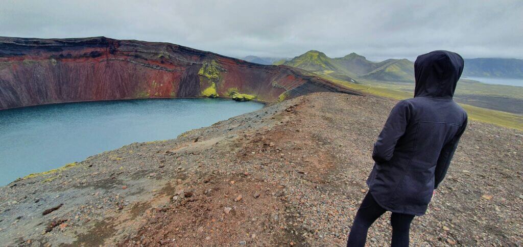
Ljótipollur
The walk took us around 5 minutes and a majestic red volcanic crater suddenly stood in front of us. We were the only visitors admiring it at that time. I don’t have any idea where were the people who arrived by the other 2 cars parked in the car park. Just us, absolute silence and a picturesque canyon filled with crystal clear water.

The weather was supposed to worsen considerably in the evening according to the weather forecast and there were already clouds gathering in the sky. Still, we were lucky that up to this point of our trip we hadn’t experienced any persistent rain. You can also hike around the Ljótipollur area but that wasn’t our plan, because Ljótipollur was already supposed to be the highlight of the area and we were really tired after Landmannalaugar hikes. That said, we left Ljótipollur and continued further towards one of the three most famous Icelandic canyons – Sigöldugljufur canyon.
Sigöldugljufur canyon
16:30-17:00
Distance from car park: 10 minutes
Time spent at: 20-40 minutes
Worth visiting even with bad weather: yes, probably
Physical condition needed: little
Interesting index: 1 – amazing  (1-amazing, 2-great, 3-nice)
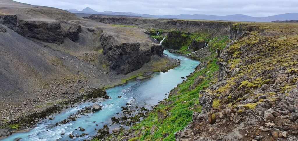
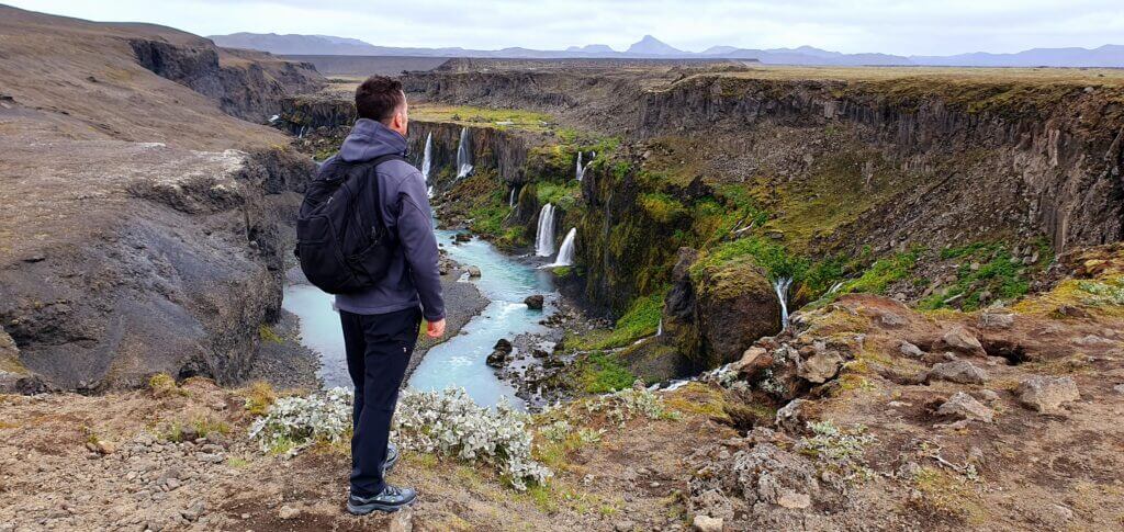
Sigöldugljufur canyon just by ourselves
Sigöldugljufur canyon was our favorite canyon in Iceland, because it was the least touristy and, in our opinion, the most beautiful. With all its remoteness it embodies for me the spirit of Iceland, i.e. a picturesque hidden place in the middle of nowhere. And that’s exactly where you will find Sigöldugljufur canyon, at the end of the road F208, in the middle of nowhere.
Google maps are quite precise with the location of canyon, although you won’t find any road signs indicating it, so you have to rely solely on Google maps. The canyon is located on the right side of F208 coming from the Landmannalaugar direction (i.e. naturally on the left side coming from the F26 direction). The only sign telling you “there’s something nearby” is the little car park near the spot which is the closest point connecting the road and the canyon marked on Google maps.
All alone at Sigöldugljufur canyon
When you leave the car park, you continue along the unmarked gravel road (used only by locals) and you keep on the left side of it, exactly as suggested by google maps. After some 10 minutes of walking, you will arrive at the right bank of the canyon and a huge network of small rivers and waterfalls of unbelievable colours will emerge in front of you. You will literally find yourself as in the middle of the fairy tale, especially if you’re as lucky as we were, and will be there all by yourself.
It’s possible to continue several kilometres ahead along the valley, so it’s just up to you how far you want to go. You are able to see the major part of the canyon already from the first moment you have it in your sight, however. That’s exactly what we did – admired it for a couple of minutes and didn’t continue further along the valley.

There’s actually no marked trail, so unless they make one anytime soon, you’re going to slightly break the rules, as you will be walking on an “unmarked path” and therefore destroying Icelandic nature a bit. We tried to go the same way back to spare the nature of our footsteps. That being said, I think it’s inevitable someone will build a marked trail heading to the canyon soon as it’s becoming more and more touristy from what I’d read before our trip.
Haifoss
18:00-18:20
Distance from car park: 5 minutes
Time spent at: 15-30 minutes
Worth visiting even with bad weather: yes
Physical condition needed: little
Interesting index: 1 – amazing  (1-amazing, 2-great, 3-nice)
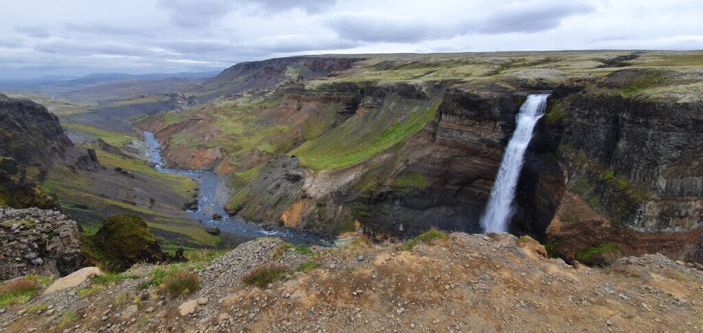
Just Haifoss
It was already around 6 pm when we were deciding whether to make a detour to Haifoss or not. I persuaded my girlfriend to do so, because this was the only time we had Haifoss quite nearby. And it was also supposed to be the tallest waterfall in Iceland, hence the one you’re going to probably include into your to-do list. The road leading to Haifoss (332) is the gravel road which you will be able to drive fast on, because it doesn’t have any potholes just a lot of gravel on it. That’s also why it’s not marked as an F-road.
Once you reach the well-marked car park, Haifoss is just a few steps next to it, in a huge moss-covered green valley with many sheep around. This is the place which is supposed to be more touristy, due to its accessibility also by 2wd cars, and yes it was even during our visit. There were some 3-4 cars other than us parking at the car park, which seemed like a lot compared to our experience at that time. There are several viewpoints of the waterfall, all next to each other so you will have enough space to admire the waterfall from and make same nice pictures. Despite weather being cloudy already, we were able to make some nice pictures anyway.

Long road towards Vik with heavy rain
18:30-22:00
After leaving Haifoss, a long road towards Vik stood in front of us. Yes, we could camp anywhere closer, but I still felt like having enough energy to do the drive and my girlfriend didn’t mind and, also, I didn’t want to camp again in the same camp – Vik. That’s why our next target destination I chose for us was the campsite in Kirkjubaerklaustur, as it had some really good reviews in Google maps. So I drove a lot. Back via road 332, then the road 32, then the road 30 and then kilometers along the road 1 just to reach the Kirkjubaerklaustur camping around 10pm. This was our most exhausting day and I’d already been tired as hell after 15 hours of being awake.
Moreover, shortly after leaving Haifoss, the weather forecast proved itself to be correct and the promised rain started and it intensified with each hour passing by. In the middle of our journey to Kirkjubaerklaustur the rain started to be really heavy and the roads were full of water, so we had to drive more carefully i.e. slower.
Kirkjubaerklaustur camping
22:00-
We reached Kirkjubaerklaustur camping in a heavy rain after 10pm and there was a huge ramp in front of the entrance to the campsite, so our first thought was “oh my god, we’re really late, what if nobody’s there?”. Luckily for us, there was still a campsite manager at that time guarding the ramp and hence we were able to pay for the camping and proceed. The campsite is very nice in a good condition and I definitely recommend camping in here. Although the weather was brutal at the time of our visit with heavy rain and wind, we still remember the campsite as one of the best.
Skipped places
- Longer hikes near Landmannalaugar
- Hjalparfoss waterfall
Landmannalaugar area is a paradise for hikers. You may easily spend there several days and still don’t have enough. We didn’t go for longer hikes this time, due to either shortage of time and us not being that much into more hardcore hiking. Not to mention, we were not equipped well enough for hikes lasting longer than just a single day.
There’s another nice waterfall near the route we drove called Hjalparfoss which we skipped. The reason for skipping it was quite straightforward – we’d already seen a ton of fascinating things on that day and Hjalparfoss was not supposed to be any special compared to the other ones we’d seen already.


This is just awesome description. All the website! Many thanks for that! 🙂
Hi,
What an amazing source of information!
The Landmannalaugar hike is on my to do list when in Iceland this June. Given all the river crossings on the F208 south (which btw sounds amazing!), would you say it’s safer to opt in for F208 north to get to Landmannalaugar? We’ll be travelling in Dacia Duster 4×4 in mid June.
Many thanks!
Dear Kasia, thank you!
In the middle of June it’s highly likely that southern (F208) and western (F225) road to Landmannalaugar will still be closed. So, your safest bet will be (F)208 north. Dacia Duster should make it fine in mid-June. There’s a medium-sized river crossing right before the campsite, so it’s better if you park your car just before the crossing, and walk the last 500m via footbridge to the campsite. We wrote in detail about this in our Landmannalaugar Guide.
Is there a campsite near landmannalaugar that is open during spetember.
The main Landmannalaugar campsite should be open in Setember. There’s also a nearby Landmanahellir campsite that should be open too.
I’ve been following your website to curate my trip to Iceland.. I gotta say, this was the only website where I’m finding every single info I want about Iceland. Kudos to you guys..
I just have a small doubt.
I’m planning to visit Iceland this April, probably in the last week, I just wanna know, is it possible to visit Landmannalaugar at all? Will the roads be open?
Or should I just skip this place and drive straight to Kirkjubaerklaustur ?
Hi Vasanth, thank you so much for your kind words!!
Unfortunately roads to Landmannalaugar are open only from June to September, so in April it’s not possible.
We write more about this in our Landmannalaugar Guide.