
Visiting the orange mountains of Kerlingarfjöll was one of our most otherwordly experiences in Iceland. We totally recommend this trip to any enthusiast of remote Icelandic highlands!
If you plan to visit this amazing place be sure to read our detailed guide to the top places in Kerlingarfjöll and best hiking trails.
Contents
Kerlingarfjoll – from the south or the north?
Well, it all depends on what your other plans are. Technically, from the south of F35, it’s a shorter route. But again, it doesn’t matter much which way you choose to start from – north or south. What matters more is, what you plan to do before and after your Kerlingarfjöll trip.
What we chose and why
For us, Kerlingarfjöll trip was day 8 of our Icelandic journey. We were doing the trip around entire Iceland with many detours. On day 7 we explored the area around Krafla and Hverir. That means, we already came from the north.
Our plan for the day was to drive the long F35 from north to south with several stops. The first highlight should have been Hveravellir hot spring area. The biggest highlight was, naturally, supposed to be Kerlingarfjöll. Finally, we wanted to finish our day on the south end of F35 in any campsite nearby. And if we had enough time, to see Gullfoss and Strokkur as well.
Just to add, the night before this trip we camped at Varmahlíð campsite. So, this was our starting point.
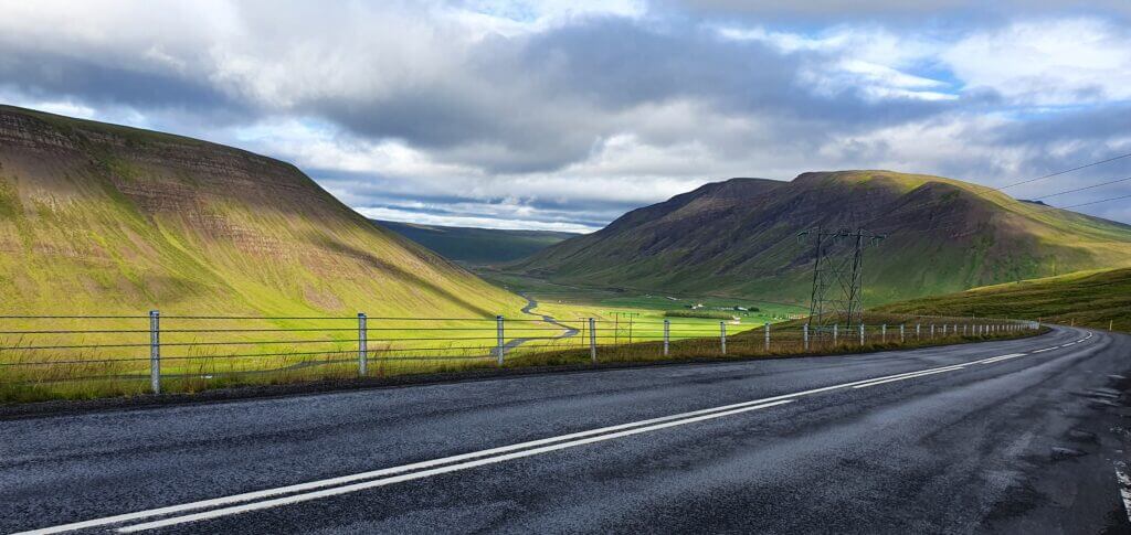
Ring road no. 1 between Varmahlíð and Svínavatn
F35 towards Hveravellir
9:00-11:00
Worth visiting even with bad weather: yes (not pleasant but should be ok to drive)
Interesting index: 3 – nice  (1-amazing, 2-great, 3-nice)
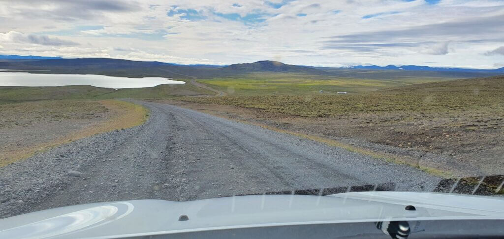
North end of the F35 road, also called Kjalvegur
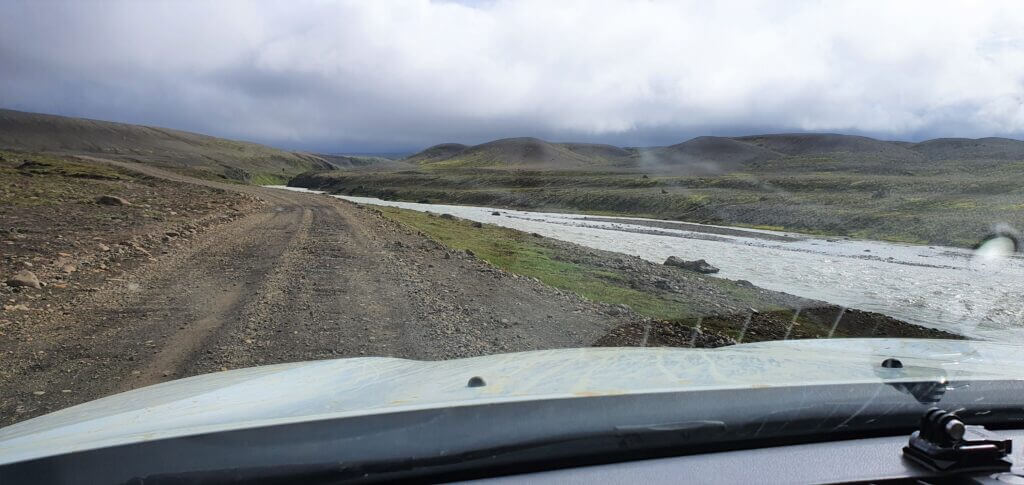
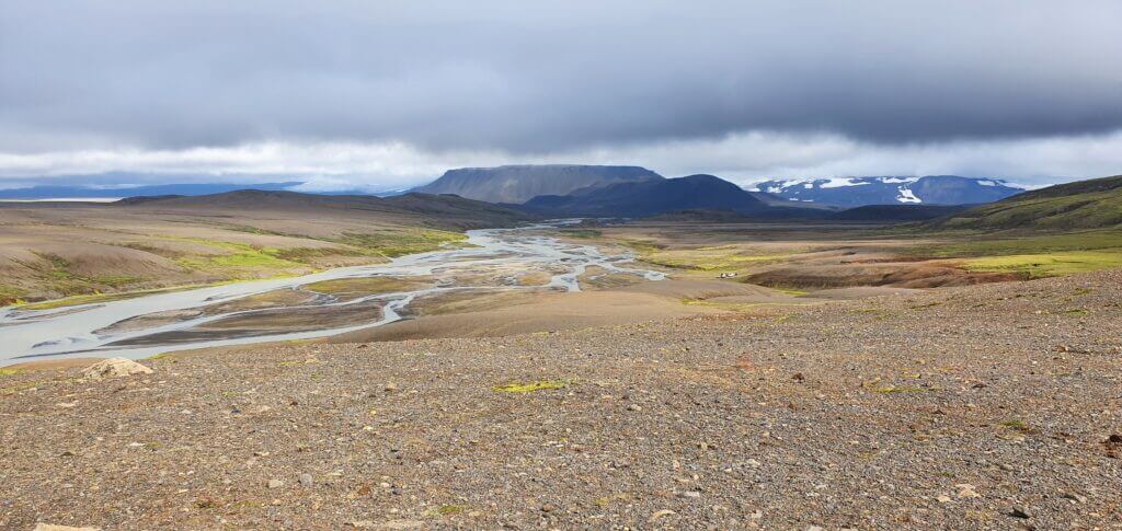
F35 is a long gravel road connecting north and south Iceland. Somewhere around the halfway through it lies the detour towards Hveravellir area and a bit further towards south lies a detour towards Kerlingarfjöll. There are better parts of F35 and there are worse parts of F35. Better parts mean you may drive quite fast (me around 100km/h). Worse parts mean a lot of potholes and turns, i.e. you have to drive slowly. Importantly, there are no river crossings on F35, only very small ponds doable even by 2wd car.
Having already seen roads like breath-taking F208 south of Landmannalaugar, out of this world F235 towards Langisjór or moon-like F905 and F910 near Askja, F35 was just an ordinary gravel road with nothing special to observe around. Bear in mind – it’s still Iceland folks – so surroundings will be nice anyway, just not that amazing compared to the best ones.
F35, aka Kjalvegur, near Hveravellir
We’ve also met probably the biggest number of cars on this F-road (read as “tourists”). This may be a bit annoying because some of them are too slow, some of them are too fast and, you know, Icelandic F-roads are not ideal for overtaking cars.
Hveravellir
11:00-12:30
Distance from car park: 2 minutes (hot spring)
Time spent at: 1 hour
Worth visiting even with bad weather: yes
Physical condition needed: little
Interesting index: 3 – nice  (1-amazing, 2-great, 3-nice)
I guess my expectations for Hveravellir were too big. When planning our trip, I had read that there are “several hot springs in the Hveravellir area”. Moreover, seeing pictures like this had instantly made me a Hveravellir enthusiast. Well, the reality was a bit different.
Hveravellir hiking trail. Pretty dull landscapes compared to other ones in Iceland
Once you leave F35 towards Hveravellir, it’s just a short, easy drive and you will soon find a parking lot in front of a small restaurant. Almost next to the parking lot lies a nice, public, free hot spring.
Since it is so close to the car park, there’s a high chance someone will be inside most of the time. Nevertheless, the hot spring is big enough and water is pleasantly hot, with some 38°C (according to my professional assessment). On the other hand, air temperature felt really cold, something like 7-8°C even in the middle of august. So again – be prepared for that – you are in the middle of Iceland, in highlands.

As there were already several people bathing in the hot spring even during Covid-19 times, we decided to be more adventurous. There were supposed to be “several hot springs” so let’s go find the other ones, we told ourselves. Hopefully with no people inside. We took one of the two hiking trails, which were fairly easy ones because they were just straight paths leading through grass fields. We were able to see quite far in the distance because there were no hills, but we were not able to observe any steam or hot spring. Thus, we continued to walk for 5 minutes, for 10 minutes, for 20 minutes and… still nothing!
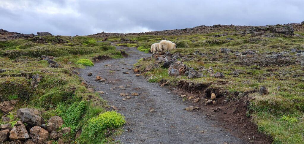
Sheep around Hveravellir trail
We don’t have anything against walking, but the entire area was pretty uneventful, with nothing interesting to observe. We said hello to several sheep along the way, but even those didn’t know where the other hot springs were. Finally, we reached a small hill, where I was able to climb up and observe the surroundings. As far as my eye could see there was no hot spring.
So, we turned back and chose a slightly different way back on one of the crossroads along the trail. We arrived back via the 2nd hiking trail and still no hot spring anywhere. Well, the hot spring picture I had seen on the internet looked incredibly beautiful, so I still felt determined at least to find out where it is. Hence, I tried my last option – went into the restaurant and asked the personnel. The guy at the desk replied “You can bath only in this hot spring, next to the car park. There may be also some other hot springs further away, but you shouldn’t bath there.” Ok, my enthusiasm ended at this point and we bathed at least in this first and only one.

Again, don’t get me wrong, it’s Iceland, so everything is beautiful (Hveravellir as well). We just had different expectations and were not that impressed at the end of the day.
F347 towards Kerlingarfjöll Mountain Resort
12:30-14:00
Worth visiting even with bad weather: yes (not pleasant but should be ok to drive)
Interesting index: 2 – great  (1-amazing, 2-great, 3-nice)
The beginning of F347 between F35 and Kerlingarfjoll
Weather was so-so, cloudy with occasional little rain, and the visibility seemed to be so-so as well. We just hoped for good visibility in Kerlingarfjöll, please not like the one on Sveinstindur. F347 also doesn’t have any river crossings and is pretty similar to F35. The closer you approach Kerlingarfjöll Mountain Resort, the more the road starts getting more mountainous and more interesting.
F347 near Kerlingarfjöll mountain resort
Once you reach the mountain resort, the entire scenery gets really picturesque. There’s a map of the area next to the resort (this map). Also, if you plan to sleep in one of the mountain huts or just in the only campsite in here, mountain resort reception is the place to go and ask for details, like key codes of the huts.
F347 near Kerlingarfjöll mountain resort
Oh, and one little note. In the first version of our Icelandic itinerary, we had planned to camp here, in Kerlingarfjoll. You can definitely do that. Just bear in mind, that on the 8th August, 3 pm in the afternoon (i.e. probably one of the warmest times possible) the temperature climbed to tropical 5°C. And the strong wind didn’t help it at all, making everything feel even some 5°C colder. Now doing the math that nights are additional 5°C-7°C colder compared to daytime temperatures, you’re going to be freezing for sure.
This is one of the coldest places in Iceland available for camping, so be prepared for that mentally, physically and with all your equipment. Given that my girlfriend had already been freezing during the past (much warmer) nights I decided to change our plans and not to camp here (and I’m satisfied with this decision).
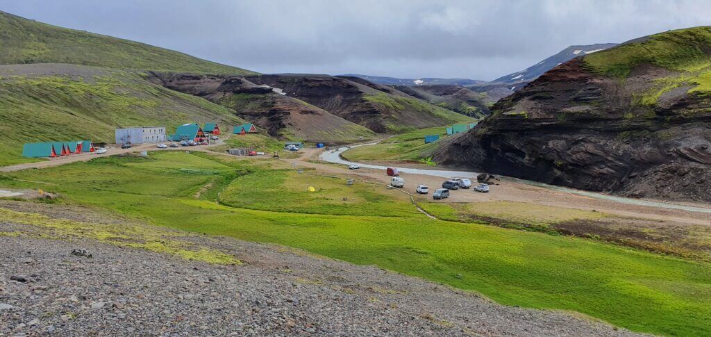
Kerlingarfjöll mountain resort campsite
Now coming back to the crux of the trip. As always, we wanted to see the best of Kerlingarfjöll and do it in a reasonable amount of time. I.e. we were not looking for a day-long hike, but rather for something like a few hours long trip. That’s why we decided to continue as close as possible to the epicentre of the area by car. That meant, to continue driving the steepest part of F347 to the end of the road, or, Hveradalir area.
F347 towards Kerlingarfjoll main area – Hveradalir
14:20-14:40
Worth visiting even with bad weather: no (the ascent may be really dangerous)
Interesting index: 2 – great  (1-amazing, 2-great, 3-nice)
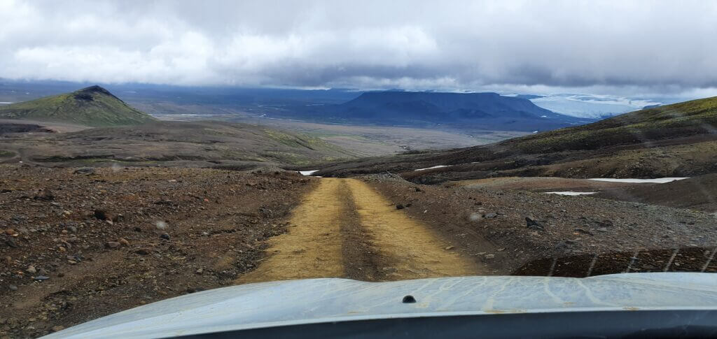
F347 road next to Hveradalir hot spring area in Kerlingarfjoll
This part of the road is the most challenging one and probably the steepest we drove on in Iceland. Again, there are no river crossings, just the road is really bumpy and towards the end quite steep. However, in good weather (read – no snow, no heavy rain) it’s definitely doable by any medium-sized SUV and better, like our Dacia Duster. If you feel unsafe, go slowly, turn 4×4 on or watch someone else go first in front of you.
Once you reach the end of the road, you will find yourself at the car park. This is the closest point to the central Hveradalir area reachable by car.
Kerlingarfjöll
14:40-16:20
Distance from car park: 2 minutes
Time spent at: 1-3 hours (or more according to your hiking passion)
Worth visiting even with bad weather: no, probably
Physical condition needed: medium to advanced
Interesting index: 1 – amazing  (1-amazing, 2-great, 3-nice)
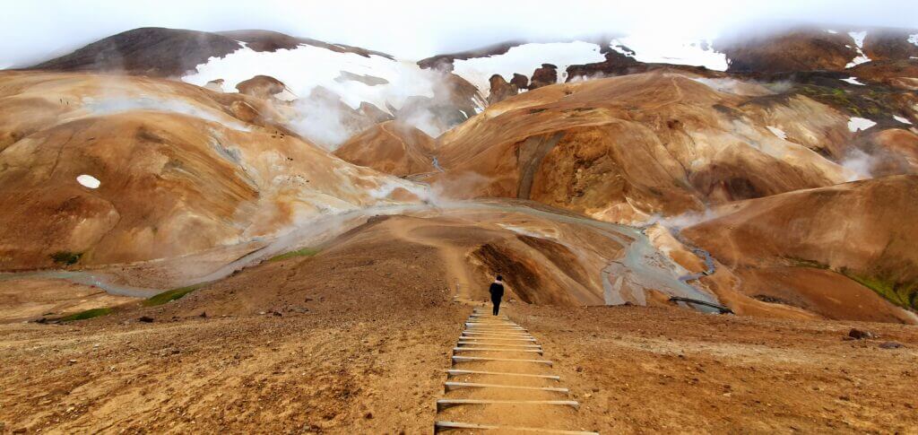
Clay staircase in Hveradalir area of Kerlingarfjöll
Kerlingarfjoll hiking options
Once in Kerlingarfjöll, you have numerous hiking options. You may for example hike to Snækollur, the highest peak of Kerlingarfjöll. This is a challenging hike, where you need to be in a very good physical shape. Snaekollur offers the best views over Kerlingarfjöll and it will take you about 5 to 7 hours. Nevertheless, the two most popular options to explore the area are shorter and easier hikes around Hveradalir hot springs.
The most popular hiking option
An option we chose – to arrive at Hveradalir geothermal area by car (steepest part of F347, past mountain resort) and to explore it from there. You may hike around the area as long as you want and as far as you want and turn back at any moment. I.e., you’re going to be returning the same way you came there. This is the most time-efficient option and allows you to see one of the most beautiful views of Kerlingarfjoll in quite a short amount of time.
One of the numerous trails in Hveradalir area of Kerlingarfjoll
Another popular option is to start at Kerlingarfjöll Mountain Resort and hike to Hveradalir yourself. It will take you around an hour to reach Hveradalir area and you may enjoy some additional nice views on top of that of Hveradalir. You have to come back the same way you arrived in here (unless you are doing a big 3-day loop with sleepovers). The big advantage of this trail is a hot spring somewhere around the first third of the trail, where you may bath. The disadvantage is the time aspect, as you will be spending additional 2 hours just getting to and from Hveradalir.
Hveradalir hike
14:40-16:20
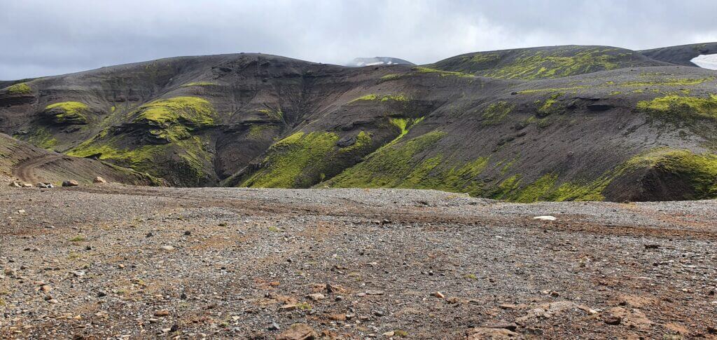
Hveradalir area is one of the most beautiful and breath-taking places I’ve ever been to in my life – together with Askja, Landmannalaugar and the F-roads south of Landmannalaugar. You literally feel like you’re on a different planet. This time it’s not rainbow mountains, no black sand, no green moss. This time, it’s orange mountains mixed with wild sulphuric hot springs and snow. A lot of snow. And cold. And the wind. Welcome to Hveradalir.
The ground is covered with clay (or something like clay) and with every step of yours it sticks to your shoes like glue. That means either take some shoes you don’t like that much or be prepared for some thorough cleaning. Hikes in here are not dangerous. At least not under normal wind conditions. And if you don’t go as far as snow-covered trails are. Then, they may be dangerous.
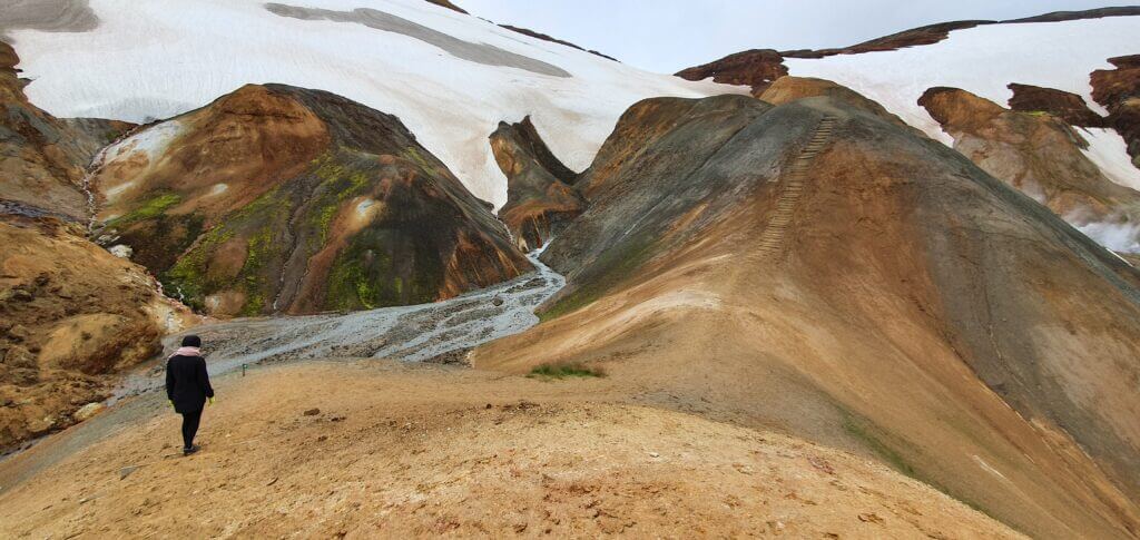
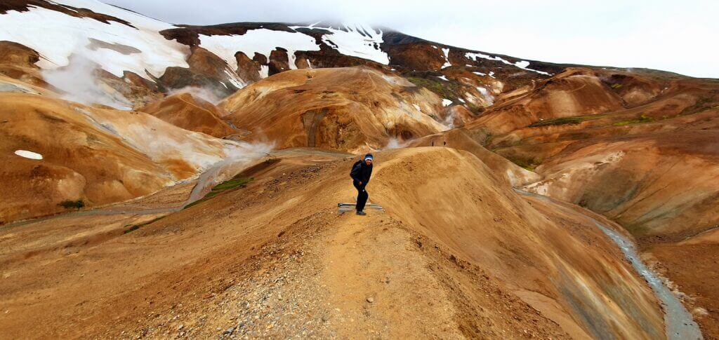
One of the summits of the several smaller hills around the Hveradalir in Kerlingarfjöll
There are several smaller hills and there are also smaller wooden stairs-like steps almost on each of them to help you with the ascent. And I do understand why. If it weren’t for them, every 10th visitor would have slipped on the clay and injured or killed himself. The views and the atmosphere of the place is truly amazing. Hot springs with hot sulphuric steam are everywhere and they help create an occasional feeling of warmth. There are, however, no hot springs to bath in Hveradalir area. This is contrary to Google maps calling the location “hot springs” or “geothermal area”.

We hiked around the area for around 90 minutes and enjoyed every moment of it. Except for the cold windy weather. With regards to visibility, clouds of fog were being replaced by the somewhat clearer sky, and vice versa, every 5 minutes. So be patient, and you may get better scenery for pictures. Or be lucky and come when the weather is clear. We hiked about 4-5 smaller hills and turned back from each one either at the end of the trail or if the trail started to be covered by deep snow, or reached high enough to be completely covered by fog.
Hot springs
Well, if you put “Hveradalir” in the Google maps, the place with no road pops up, quite far from the car park. However, Hveradalir area starts right next to the parking lot so this data point is slightly mistaken. The second confusing thing is if you are looking for hot springs to bath in. You will not find them in Hveradalir. Although Google is saying this is a hot spring area, yes, it is, but you can’t bath in any.

And it’s not easy to find it where the hot spring available for bathing actually is. We’ve accomplished that by asking a receptionist at Kerlingarfjoll mountain resort. She told us that the only hot spring with the bathing option is roughly in the one-third of the trail from mountain resort towards Hveradalir. I.e. after some 20 minutes of walking. Well, we already had enough and the weather started to get foggy and rainy, so we decided to go on with our journey. But firstly, we had to clean our shoes for at least 15 minutes to get off the Kerlingarfjoll clay.
Gullfoss
18:55-19:15
Distance from car park: 5 minutes
Time spent at: 10-20 minutes
Worth visiting even with bad weather: yes
Physical condition needed: little
Interesting index: 2 – great  (1-amazing, 2-great, 3-nice)
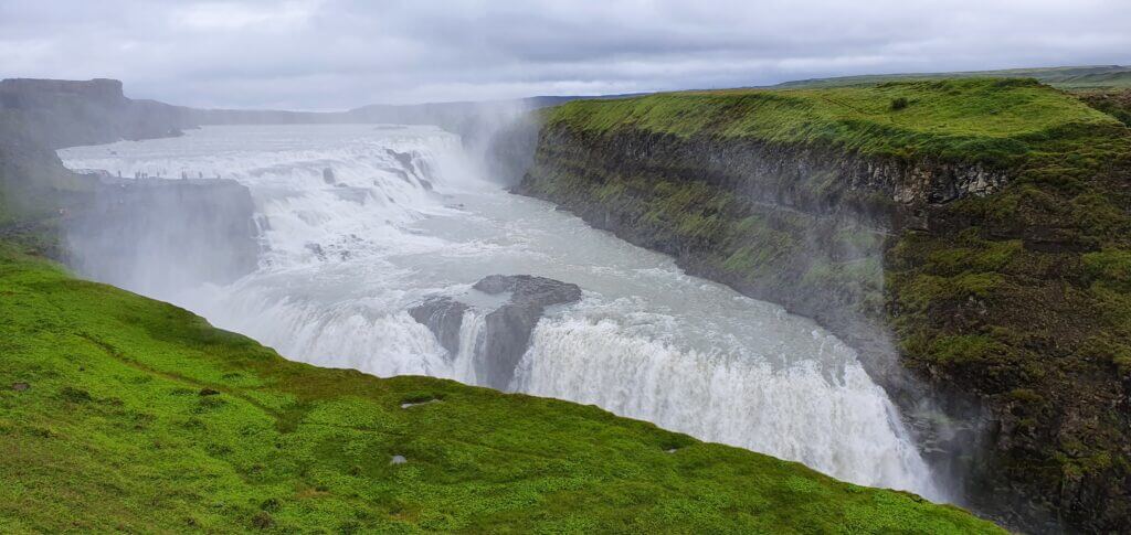
Gullfoss at the time of our visit, i.e. 7 pm
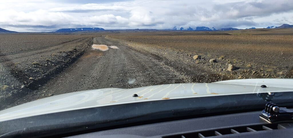
The rest of the F35 towards the south, starting in Kerlingarfjoll is about the same as the northern part of F35. That means no river crossings, a lot of potholes and countless acres of deserted highlands. The logical option when arriving at the south end of F35 is the famous Gullfoss waterfall. And we followed this logical option.
Despite being tired already, we decided to go for 2 last sights. First of them was Gullfoss, or typically one of the most touristy places. You’re going to notice it once you arrive at the gigantic car park next to the restaurant and souvenir shop. However, we arrived in the evening during Covid-19 times. This meant an empty car park and a closed restaurant with a souvenir shop. And also – almost no tourists.

The waterfall is very easily accessible, which probably explains why it’s usually so touristy. It’s also very picturesque. It wasn’t one of our favourites, though. We were already spoiled enough with all of the places we had seen already at that time. As someone on the Google maps had put it “3/5 Icelandic stars, that is 5/5 stars anywhere else”.
Strokkur
19:30-20:00
Distance from car park: 5 minutes
Time spent at: 10-40 minutes
Worth visiting even with bad weather: yes
Physical condition needed: little
Interesting index: 2 – great  (1-amazing, 2-great, 3-nice)
Being encouraged by the low number of tourists at the time of our visit, we decided to continue to our last point of interest on that day. Again, a logical choice, just a few minutes of drive from Gullfoss – legendary Strokkur. This time, we aimed for the undeniable number one in the ranking of touristy places. We arrived at this parking place and there were only 2 other cars. Maybe we are wrong? Too far away from the actual geyser? No, we were right.
Yes, at the time of our visit there were 6 other people than us near Strokkur. Now comes a little trivia window again. There are two geysers at this place. The old one – “Geysir” and the new one – “Strokkur”. The trick is, Geysir only erupts very rarely (if ever), whereas Strokkur erupts every 2 to 10 minutes. So better don’t wait for the Geysir to erupt.
What’s there to add? Watch the eruptions as many times as you’d like to and you’re good to go.
Flúðir camping
21:30-
I was planning to bath in the Hruni hot spring, the next day in the morning so I picked a Flúðir campsite for us, right next to Hruni. Well, the campsite was very simple and belongs to the worse ones from all of those we’ve been to in Iceland. Nevertheless, at least it had showers. I don’t remember any kitchen area though. Luckily, this day we had our only restaurant dinner, so no need for the kitchen.
Skipped places
• Fosslaug hot spring
• Secret Lagoon Hot Spring
Although Fosslaug hot spring seemed like a very cool place to soak in, we decided to skip it. Fosslaug is located near Varmahlid and would be a detour on our way to Kerlingarfjoll. And Kerlingarfjoll was our priority for that day, so we decided to go for more hot springs in the following days.
The same holds for the Secret Lagoon Hot Spring, with little addition of being touristy as well. We definitely preferred an experience of wild hot springs, rather than organized and touristy ones.


Hi Igor, I need your help. My idea is to drive on June 18 the F35 from north to Strokkur, hoping it will be opened. We will have a rented Dacia Duster.
I have 2 possibilities:
June 17 – starting from Godafoss, sleep very close to the entrance of F35 (Bólstaðarhlíð)
June 18 – stop at Kerlingarfjöll, reach the Hveradalir geothermal area by car, hike Hveradalir. After that continue the trip by car, along F35, till Strokkur area for overnight.
The second one is:
June 17 – starting from Godafoss, sleep at The Highland Base at Kerlingarfjöll (hotel)
June 18 – reach the Hveradalir geothermal area by car or by foot, hike Hveradalir. After that continue the trip by car, along F35, till Strokkur area for overnight.
My question is: is it possible to complete the F35, including the hike to Hveradalir, in a single day? On the other hand, it would be great to overnight in Kerlingarfjöll to be in the right place at the right time (I like photography) but, sleeping in the area costs €240 more than sleeping in Bólstaðarhlíð. If the F35 and/or F347 are still closed, I’ll lose the money. Furthermore, there’s also the risk of bad weather. For this reason, the first option is probably better, but I’d like to know if it’s feasible. Thanks so much for your help.
Hi Paolo, option 1 is approximately a 5 to 6-hour drive, so it’s definitely doable if you leave early in the morning. 4-5 hours for Hveradalir should be enough, so you still have plenty of time with long light in June. Have a great trip!
P.S.: If you like what we do at Epic Iceland and/or if you appreciate my response, please a short review on Google: https://g.page/r/CaJt1bHCTbF1EBM/review would really help us 🙂 Thanks in advance.