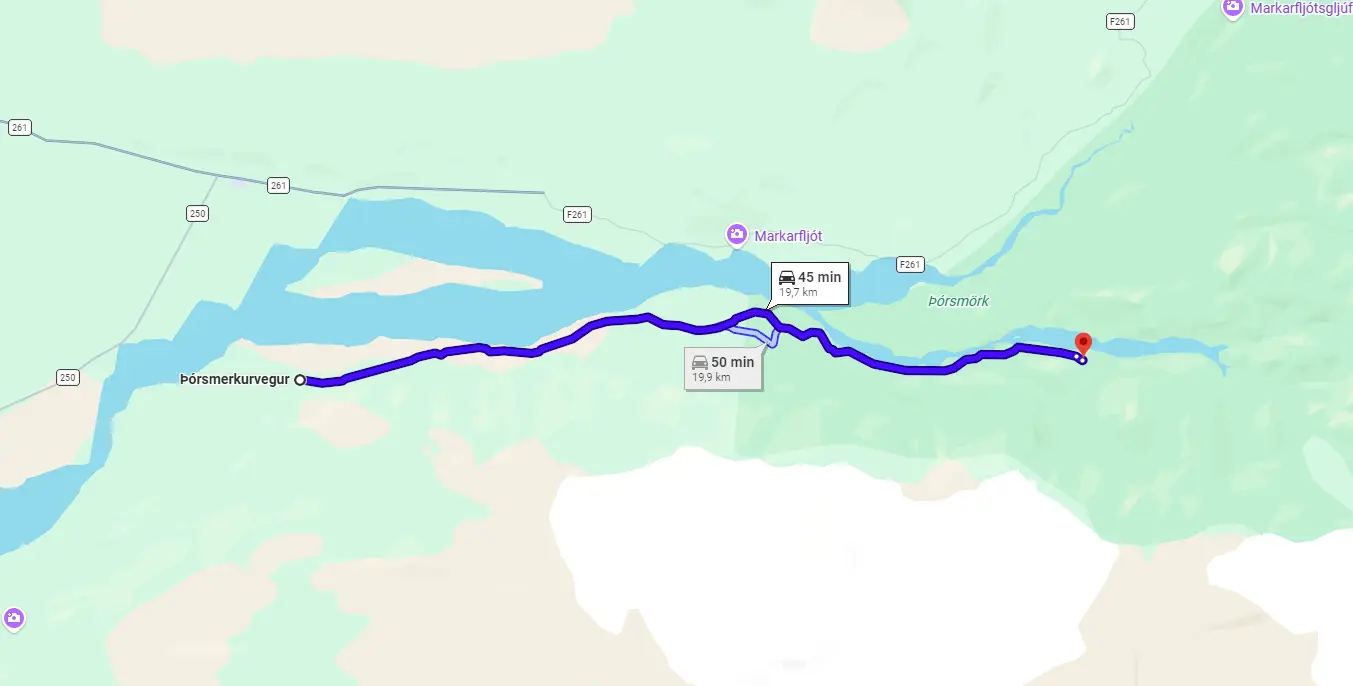
F249, or in Icelandic Þórsmerkurvegur, is an F-road in southern Iceland leading through the lower edge of the Icelandic highlands. It is the only F-road leading directly to Þórsmörk – an unbelievably beautiful valley surrounded by glaciers and dramatic mountains. F261 runs along the northern side of the Þórsmörk area but does not lead into the valley itself.
F249 is probably the most notorious F-road in Iceland when it comes to drowned rental cars. The reason is simple – the river crossings start out small and manageable, but they get bigger and bigger as you drive deeper towards Þórsmörk. The final crossing – the Krossá river – is arguably one of the biggest unbridged river crossings you will find on any marked F-road in Iceland.
This guide covers everything you need to know before driving F249. Road conditions, river crossings, the right car, best stops, and our own experience – all in one place.
Contents
Overview of F249
F249 leads to the following three destinations:
- Básar Hut (base for Fimmvörðuháls hike) – no crossing of Krossá river
- Húsadalur campsite (Volcano Huts) – west crossing of Krossá river
- Langidalur campsite (with summer footbridge over Krossá) – east crossing of Krossá river
F249 – Þórsmerkurvegur
Length: ~31 km | 19 mi (road 249 + F249 from Ring Road to Básar)
Driving time: 1.5-2 hours one way (without detours and stops)
Difficulty: 8/10 - Difficult F-road
Steepness / roughness: flat, big gravel
Unbridged river crossings: many - small to very big (Krossá)
Opening time: late May / early June
Closing time: September
F249 opening dates
F249 is not part of the official Vegagerðin (Icelandic Road Administration) opening date statistics. This is likely because it starts at a relatively low elevation near the Ring Road and connects to a valley rather than deep highland terrain.
Based on our data over the past years, F249 typically opens in late May or early June. It tends to be one of the earlier F-roads to open each season. That said, river conditions – especially the Krossá river – can make the road effectively impassable even when it is technically open.

Always check the current road status at www.umferdin.is before going. A green status is a good sign, but it does not tell you the actual water level of individual rivers. When in doubt, ask locals.
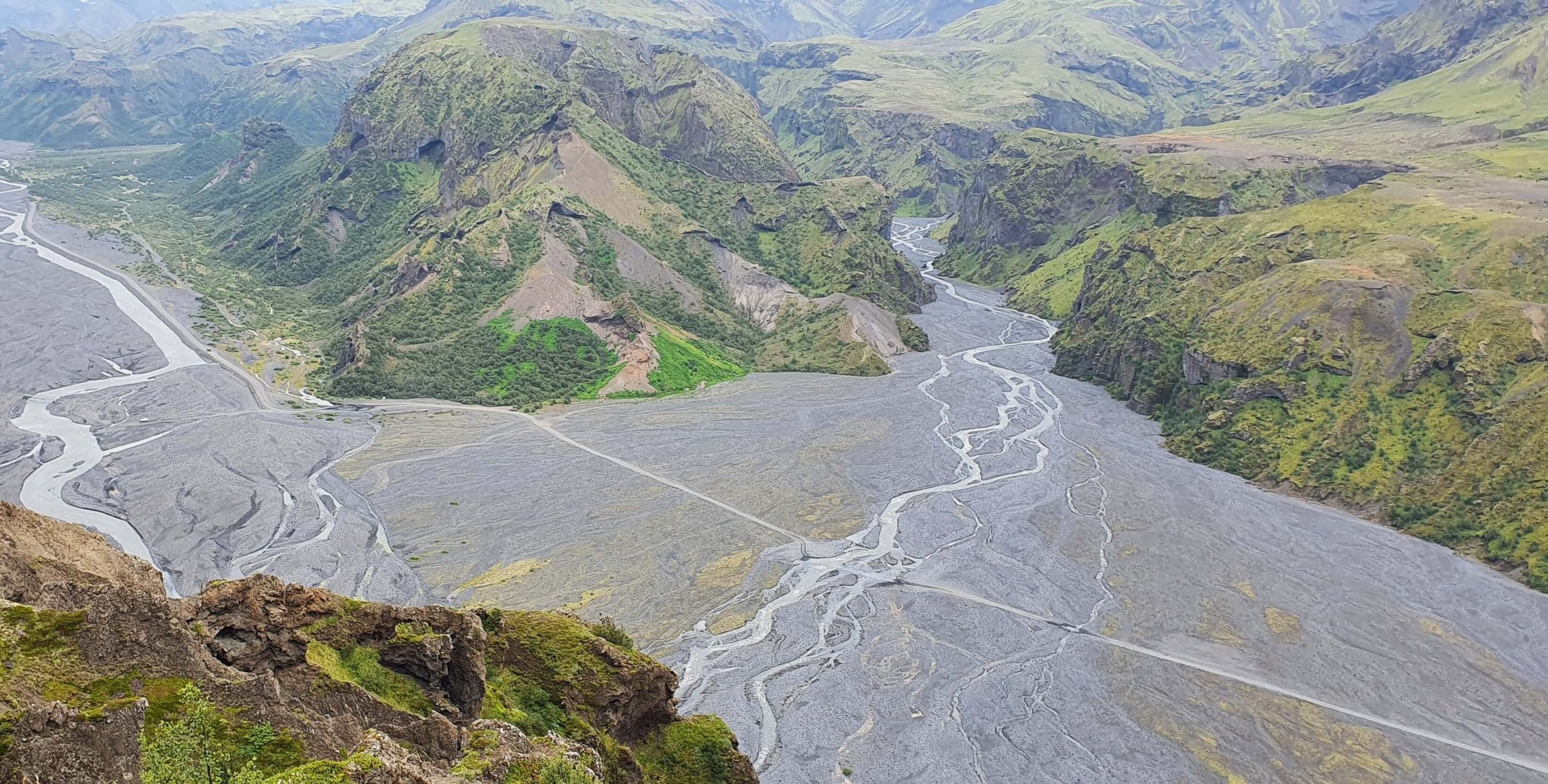
F249 Map
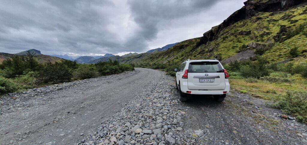
The road starts at a junction off road 249, which branches off the Ring Road near Seljalandsfoss. From there, the paved section of road 249 transitions into the gravel F249 after roughly 10 km.
F249 Þórsmerkurvegur on Google Maps:
Icelandic Maps:
Connecting roads
- Ring Road 1 (near Seljalandsfoss – start of road 249)
- Road 249 (paved section leading to F249)
- Gígjökull track (dirt track detour to Gígjökull glacier tongue – super jeep only)
Nearby roads:
- F261 – Emstruleið (runs along the northern side of the Þórsmörk area, connects to F210)
- F210 – Fjallabaksleið Syðri (connects to F261 further east)
F249 River Crossings and Obstacles
F249 River Crossings
F249 has multiple river crossings. They start small – almost just puddles – but they gradually get bigger and more serious as you drive deeper into the valley. This is exactly what catches many tourists off guard. The road looks harmless at first.
The first crossing worth mentioning is the one near the Lónið lagoon. Here the river can look scary because the current is strong and the water is often murky. However, it is usually passable – just make sure to wade it first if you feel uncertain, or wait for someone else to cross first.
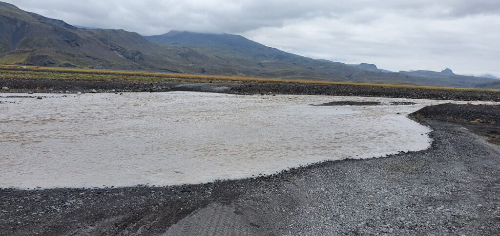
First scarier river crossing on F249 next to Lónið lagoon
Further along, the Steinsholtsá river is one of the rivers known for drowning rental cars. It is a medium-to-big crossing depending on conditions. At the time of our visit the water levels were low, but we still approached it with full respect. Never take this one lightly. You have to cross Steinsholtsá to get to Stakkholtsgjá canyon.
After Steinsholtsá, there are more crossings before reaching the area around Langidalur campsite – including Stakkholtsgjá and Hvanná. These were similar in character to Steinsholtsá. We drove all of them in our super jeep without major problems, but only because the conditions were close to ideal that day.
The Krossá river is the final and by far the biggest crossing. It is widely considered one of the most dangerous river crossings on any marked F-road in Iceland. The current is powerful, the riverbed is very uneven, and the depth is unpredictable. We chose not to cross it by car, even with our super jeep and even under good conditions. Most experienced drivers will tell you the same.
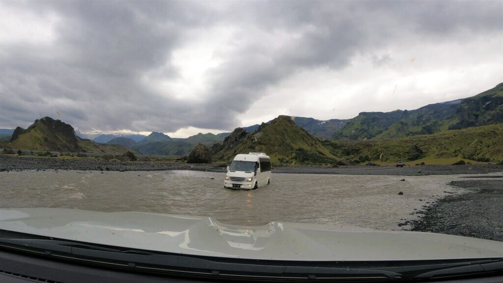
Crossing Steinsholtsá river on F249
You do not need to cross Krossá to enjoy Þórsmörk. There is a footbridge across Krossá, which lets you continue to Langidalur campsite and the Valahnukur hike on foot. The footbridge is in place during summer, but rangers may remove it when water levels are too high. If the bridge is gone, the only way through is by super jeep bus (5% discount code in our newsletter), or a very experienced local driver.
Read more about how to cross rivers in Iceland before driving F249. And please follow all the steps – no shortcuts.
Obstacles
F249, a dangerous road to Thorsmork, due to its river crossings.
Outside the river crossings, F249 is actually not a technically difficult road. There are no steep sections and no major potholes. The main issue is the big gravel, which means you have to drive slowly and accept a bumpy ride – but that’s true of most F-roads.
The Gígjökull dirt track – a detour from F249 towards the Gígjökull glacier tongue – is a different story. The approach road to the glacier is very rough, with big holes and sharp boulders. We tried it twice and turned back both times. If you attempt it, be prepared.
Car Requirements, Weather, and Safety
F249 Car requirements
F249 is one of the roads in Iceland where the car choice matters a lot – probably more than anywhere else. The terrain itself only requires a standard 4×4. But the river crossings, especially Steinsholtsá and Krossá, are a completely different story.
Minimum F249 Car Requirement: Large 4×4 (Land Cruiser, Defender) (*under ideal conditions, not attempting Krossá)
Recommended F249 Car: Super jeep (with snorkel, 33″+ tires) (**under average conditions)
“Peace of Mind” F249 Car: Larger super jeep (40″+ tires, super high ground clearance) (***for worse conditions)
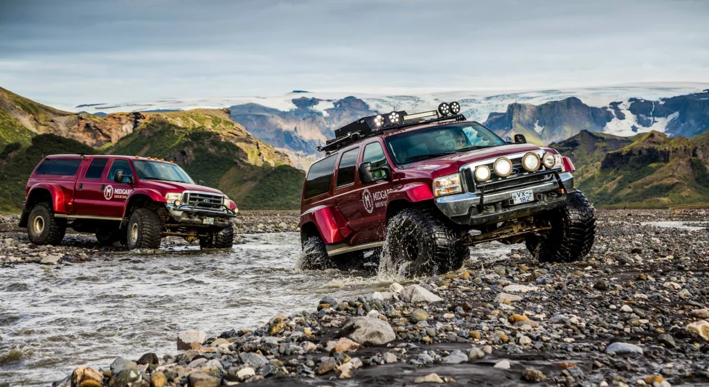
A “peace of mind” super jeep tour in Thórsmörk by www.midgardadventure.is, 10% discount code: EPICICELAND10
Never drive the road in any car when it’s marked red = impassable on www.umferdin.is or when the conditions are too difficult!
A slightly raised 4×4 with 33″ tires and a snorkel like a Land Cruiser may get you most of the way to Þórsmörk and is fine if you plan to park before Krossá and continue by footbridge. If you want to actually attempt Krossá, you need a proper super jeep with a snorkel – and even then, it’s not guaranteed. Some 40″ super jeeps have gotten stuck in Krossá. The car is only one part of the equation. The river crossing technique matters just as much.
Feel free to read how to choose a proper car for Iceland or how to pick the best Icelandic car rental insurance. We also collaborate with the best Icelandic companies to give you a car rental discount and us a small commission at no extra cost to you.
F249 Weather and Safety
Before going to Þórsmörk, always check the Icelandic weather forecast, current road conditions, and travel warnings. River levels on F249 change fast with rain or warm temperatures melting the glaciers above.
Þórsmörk is located in a valley surrounded by three glaciers – Eyjafjallajökull, Mýrdalsjökull, and Tindfjallajökull. This means glacial melt has a direct impact on river levels. A warm sunny day can actually make rivers higher in the afternoon than they were in the morning. Plan accordingly.
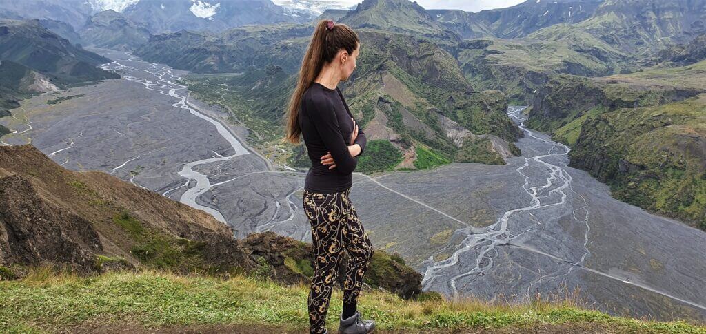
A spectacular view from Valahnukur in Thorsmork above F249
The good news is that Þórsmörk’s position in the valley means it is often sheltered from storms that hit the surrounding area. The weather in the valley can be noticeably better than just a few kilometers away. That said, always check before you go.
Bring enough fuel. There are no gas stations or shops along F249. Cell coverage might be unreliable in the valley. If you feel unsure, register your trip at safetravel.is before you go.
Highlights and Attractions
F249 leads to one of the most beautiful valleys in Iceland. The road itself is not the main event here – it’s the destination. But there are several great stops along the way that are worth slowing down for, and some of them can even be reached without a 4×4 car.
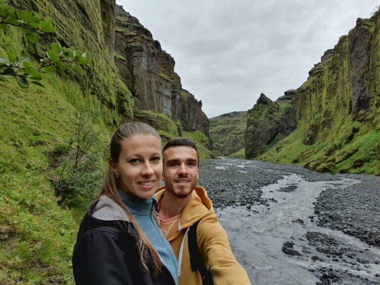
Þórsmörk valley as a whole is the main draw – a green, lush, lunar-like landscape surrounded by glaciers, black sand riverbeds, and dramatic ridges. Once you are there, hiking is what the area is all about. The most popular short hike is Valahnúkur, which gives stunning panoramic views over the whole valley.
Magnificient Nauthusagil itself
Off-the-beaten-path Spots
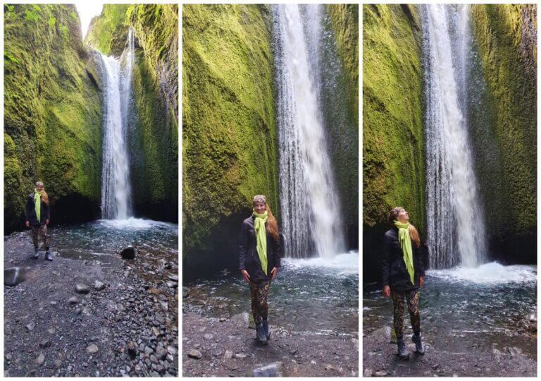
- Nauthúsafoss waterfall – one of the most magical spots we’ve seen anywhere in Iceland. Accessible even by a 2wd car from road 249. Absolutely do not skip this one.
- Stakkholtsgjá canyon – a stunning narrow ravine with a waterfall at the end. Requires crossing a small river by foot inside the canyon. Takes about 40 minutes one way. Don’t turn back before reaching the end – the best part is right at the finish.
- Gígjökull glacier tongue – a striking glacier descending from Eyjafjallajökull. Reachable via a rough dirt track off F249. Super jeep only.
- Valahnúkur hike – the best short hike in the entire Þórsmörk area. 30 minutes one way from Langidalur campsite. Views all around the valley are simply stunning.
- Fimmvörðuháls pass – a full-day hike starting from Þórsmörk, connecting to Skógar. One of the most dramatic hiking routes in Iceland.
Did you know that
- Þórsmörk is named after Thor – the Norse god of thunder? Whether that means anything for the weather there is up to you to decide 🙂
- The Krossá river crossing is considered one of the most dangerous river crossings in Iceland, alongside Skyndidalsá on F980?
- Even the official Icelandic highland bus has gotten stuck in Krossá when water levels were high?
- You can reach Langidalur campsite and Valahnukur hike in Þórsmörk without crossing Krossá by car – just park before it and use the footbridge?
- Nauthúsagil waterfall – one of the most beautiful stops along the road – is accessible even without a 4×4 car?
Stakkholtsgjá canyon Þórsmörk
Comparison to other F-roads
- What makes F249 unique is the combination of a relatively easy road surface with some of the most intense river crossings in Iceland. The road itself is flat and non-technical – but the rivers make it one of the most demanding F-roads out there.
- Compared to F261 Emstruleið, F249 has harder river crossings overall. F261 runs along the northern side of the Þórsmörk area and connects to F210 – it does not lead into Þórsmörk valley itself. F261 is easier to drive than F249 but takes you to a different destination.
- Compared to F210 Fjallabaksleið Syðri, F249 still has a higher level of difficulty when it comes to river crossings (maybe except Hólmsa east of Maelifell). F210 has harder terrain and more remote conditions, while F249 is shorter and closer to the Ring Road.
- Compared to F208 South, F249 has significantly bigger and more dangerous river crossings. F208 South requires a medium 4×4 minimum; F249 really needs a super jeep if you plan to go all the way.
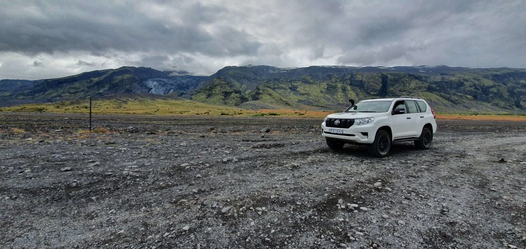
Toyota Land Cruiser in Thorsmork with Gigjokull glacier in the background
Where to stay near F249
There are a few good accommodation options depending on how you want to approach the trip.
Near the start (Hella / Seljalandsfoss area):
- Hotel Skógafoss or guesthouses around Hella – very convenient base for an early departure towards F249
- Accommodation near Hella – we based ourselves here and it worked perfectly for a day trip to Þórsmörk
In Þórsmörk itself:
- Volcano Huts Þórsmörk (Húsadalur) – great base for hiking
- Langidalur campsite (run by FÍ) – located right next to the Valahnúkur hike; to reach it by car you need to cross Krossá
- Básar hut – another option on the F249 side before Krossá, serviced by highland buses
Road Videos
Our drive through F249 towards Þórsmörk, including river crossings and stops along the way:

Personal Experiences and Tips
Let’s talk about our first F249 trip, because this is how most of you will experience this area.
We based ourselves near Hella and chose Þórsmörk for our first day, mostly based on the weather. A Þórsmörk day trip really does need good conditions – not just for safety, but because when it’s foggy, you lose most of the visual drama of the place. Our Icelandic friends also told us the rivers were low those days, which made the decision easier.
We left at 9 AM and headed towards Seljalandsfoss, where the turnoff for roads 249 and F249 lies. Our goal for the day was Langidalur campsite and the Valahnjúkur hike. We had already decided we were not going to attempt Krossá by car – not because of the car (we had a super jeep), but simply because it wasn’t worth the risk when the footbridge was in place.
The first stop was Nauthúsagil waterfall, still on road 249, accessible even by a 2wd car. We had studied it beforehand but were still completely unprepared for how good it actually was. Walking the narrow gorge with the stream running beneath your feet and arriving at the hidden waterfall at the end – this place became one of our absolute favorites in Iceland. Go there before the crowds find it.
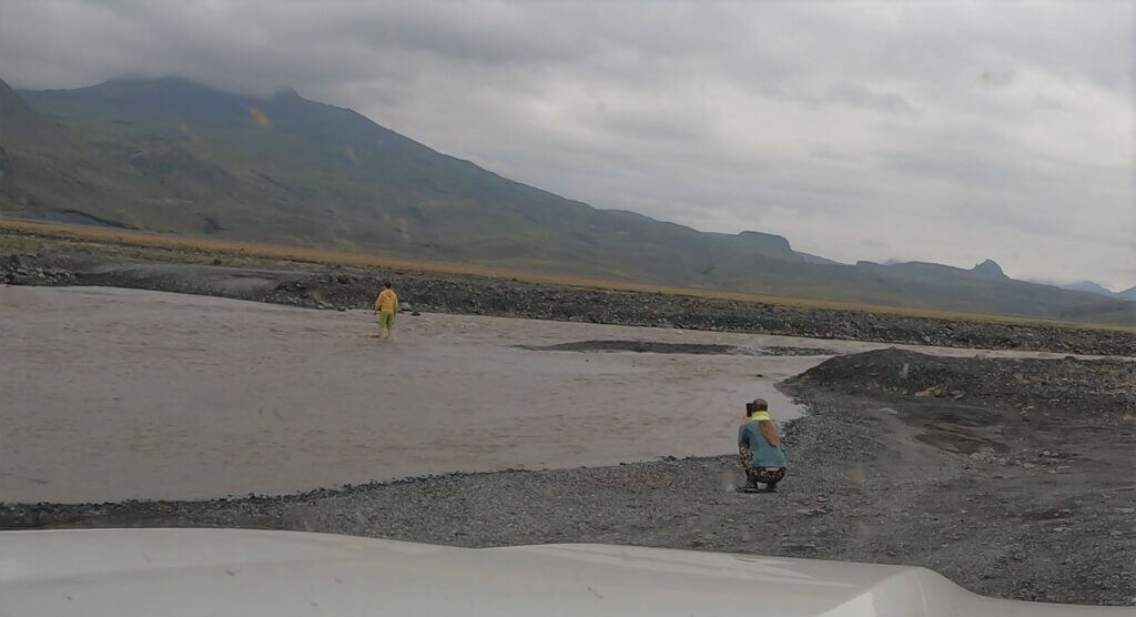
Me wading river Lónið at F249 in Thorsmork
Once on F249, the road transitions into big gravel. There are no steep sections, but you have to slow down and accept the bumpy ride. The river crossings start soon after. The one near Lónið lagoon looked scary – fast and murky – but we waded it first and found it was shallow enough. The Steinsholtsá crossing came next, with more respect from our side. We watched the car in front of us cross first, waded it ourselves to check the depth, and then crossed without issues. In worse conditions, this one would not be passable.
We also stopped at Stakkholtsgjá canyon. This place is extraordinary. We spent close to two hours there – walking the canyon, figuring out how to ford the small river inside without getting wet, and making it to the hidden end of the ravine. Without going all the way to the end, you miss the best part.
At Krossá, we parked the car well off the road (not blocking any bus track) and crossed by footbridge. We then watched a highland bus do the Krossá crossing by car. The bus didn’t go straight – it turned downstream before crossing. Even under low water conditions, the bus was visibly shaking on the uneven riverbed. No regrets about leaving the car behind.
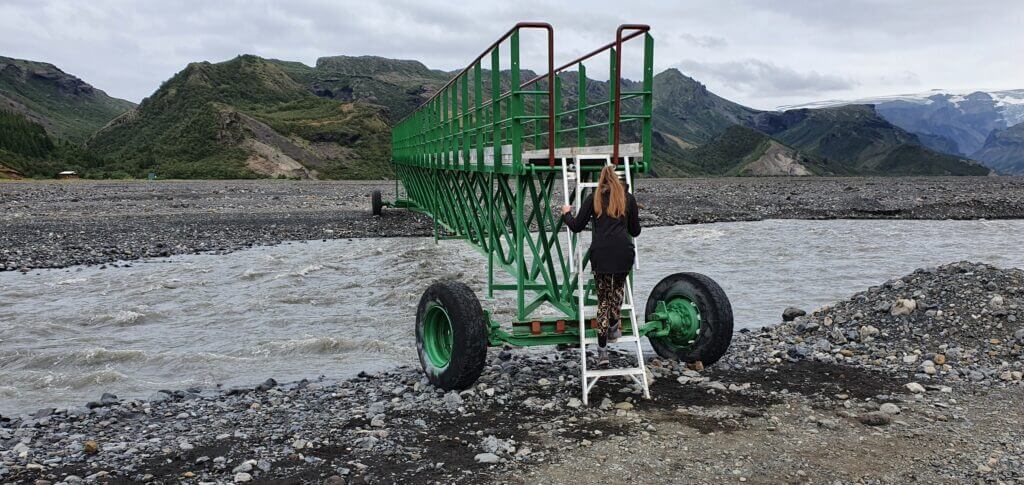
Thorsmork Krossá Langidalur footbridge
The Valahnjúkur hike from Langidalur took us about 30 minutes to the top. The views from up there over the whole Þórsmörk valley – glaciers on three sides, black sand rivers below, green moss all around – were worth every single awkward river crossing on the way there.
A few tips from our side:
- Start early. F249 with all the stops easily fills a full day, and river conditions in the afternoon can be higher due to glacial melt.
- Wade the rivers before crossing by car, always – even the smaller ones. The current tells you a lot about what’s coming underneath.
- Don’t skip Nauthúsagil. It’s before the first river crossing, accessible without a 4×4, and one of the best places in the entire area.
- Park well clear of the road before Krossá. Buses and super jeeps need the space. Use your common sense and park on the gravel off to the side.
- Check road conditions at umferdin.is on the morning of your trip. Check again before you leave. And ask locals if you can.
- Download offline maps before going. Cell coverage disappears once you’re in the valley.
![]() ask questions or get inspired in our community
ask questions or get inspired in our community