Laki craters are an amazing remote place in the Icelandic highland in the south. Climbing Mt. Laki and seeing the remnants of the 250-year-old eruption is an unforgettable experience. The eruption changed European history and we were able to feel that pretty lively when visiting Laki volcanos.
Contents
Rainy forecast – what to do?
We had beautiful weather during the first 3 days of our trip. Then the weather got worse, exactly according to the forecast. In our case, this meant some rain at most of the places in the south and clouds everywhere. Light rain is still good, unless the visibility worsens, i.e. unless fog appears. Because once it does, any place with a view won’t serve you any view.
Our summer season in Iceland was very specific, with the south having colder, cloudier, and more rainy weather compared to the north and the east. And this persisted throughout most of the summer. For our trip, we planned 9 days in the south and 9 days in the north and the east. So, the question was – with 3 already nice days – what to do with the 6 remaining days which were supposed to be rather rainy?
F207 around Laki craters in rainy weather
Luckily, the rain often isn’t everywhere. This means, that even in a rainy forecast, it’s often possible to find some places where it either doesn’t rain a lot or it even doesn’t rain at all. And that’s what we actually successfully achieved – to “chase the non-rainy skies”. We wrote an entire article about that – “How to find a nice weather in Iceland”, feel free to read it.
This was exactly the case also on Day 4 of our trip – rainy forecast for most of the south. Yet, we managed to find some local regions where the forecast didn’t show the rain. One of them was Laki craters.
Be sure to also check our List of the 25 Best Places in the Highlands of Iceland!
How to get to Laki craters
Almost everyone knows where the Fjadrargljufur canyon (Justin Bieber canyon) lies. Yet, almost nobody knows where Laki craters are 🙂 Even despite the fact that, in my opinion, Laki craters are 100x times more interesting than the over-touristy Fjadrargljufur canyon. And surprisingly, the road to Laki craters is located right next to the Fjadrargljufur canyon.
You can also take a super jeep tour to Laki.
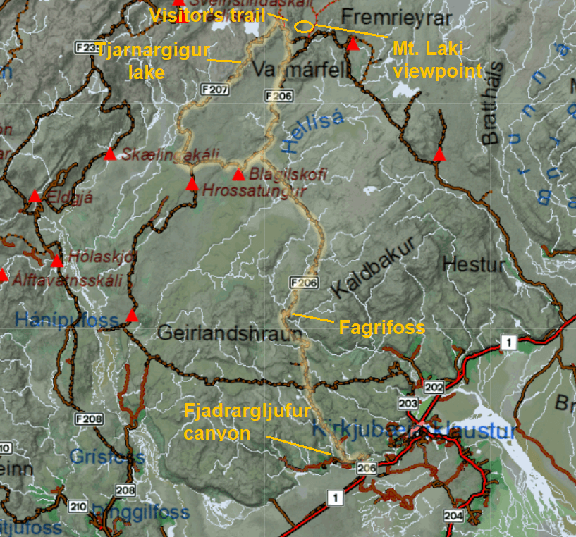
Laki craters roads map
F206 and F207 to Laki
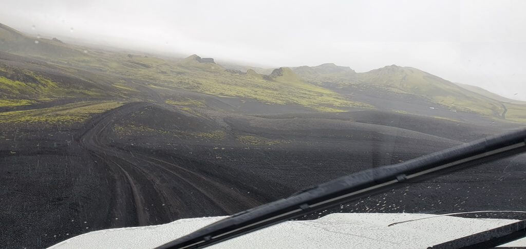
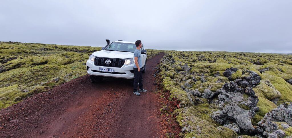
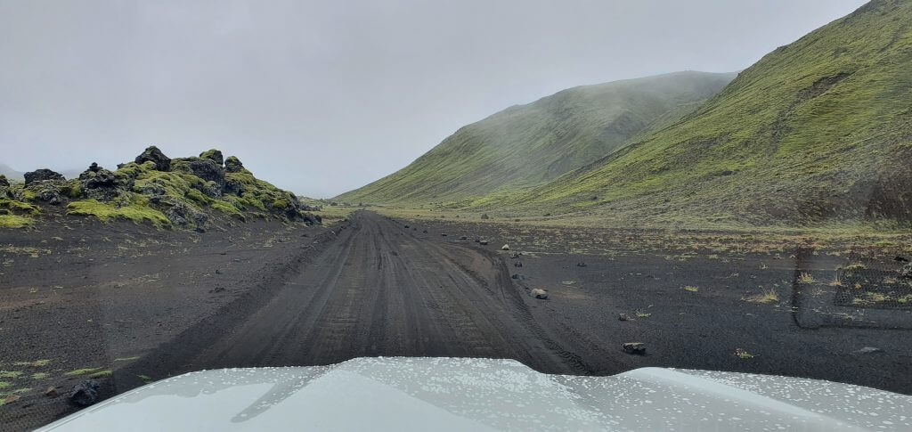
F206 – Lakavegur and F207 – Lakagigavegur are F-roads leading to and around Laki craters. Roads are quite long and you have to drive slowly on them, because of their uneven surface and narrow paths. I drove there twice this summer – once in light rain and total fog, the second time in cloudy weather, but with good visibility. If it’s foggy, you definitely have to slow down even further.
F206 to Laki craters in rain and fog
If it’s not too rainy or it has not rained too much in previous days/weeks (rising water levels in the rivers too much), even an ordinary 4×4 like Dacia Duster should be enough for the road – when driven carefully. To be almost 100% sure to pass without any damage, I, however, do recommend bigger 4×4 like Land Cruiser or Defender.
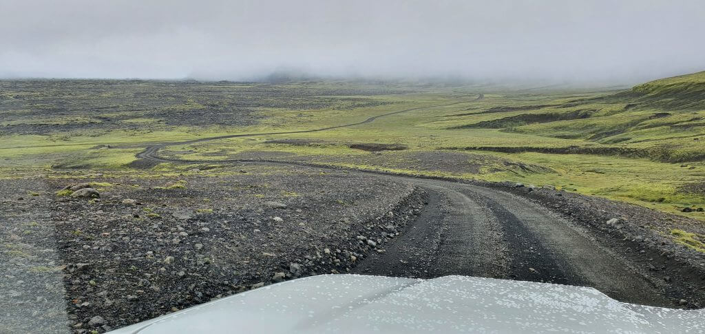
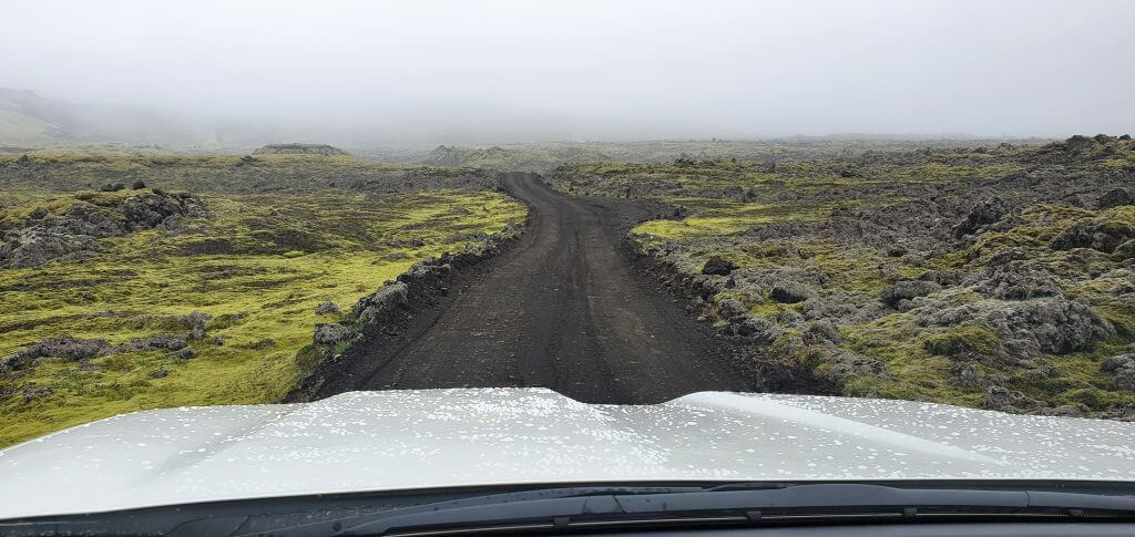
The roads lead through various different landscapes. Some of them are full of moss. Some of them are just huge gravel areas. And some of them are already part of a volcanic crater area near actual Laki craters. The landscapes around F206 and F207 leading to Laki are beautiful and I do recommend taking your time to go and see them.
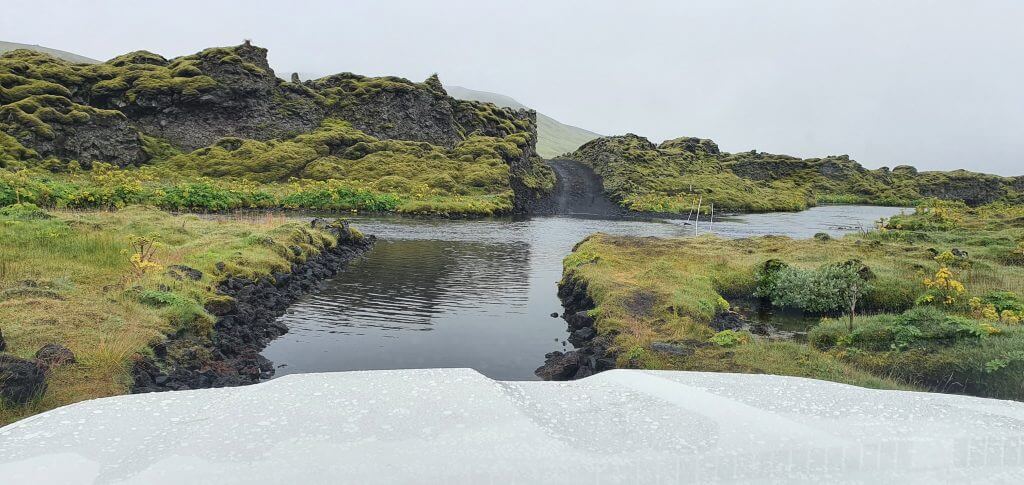
F207 river crossing (road to Laki craters)
There are two medium-size river crossings on roads F206 and F207. One is on F206 leading to the ranger’s hut a.k.a. tourist information center next to Mt. Laki. The other river crossing is near the end of the F207 loop around the Laki craters area. Both F206/F207 river crossings are similar – the water is calm (no strong current) and the riverbed is pretty even and flat. The only issue is with the water level which varies. At the time of our visits, however, water levels were very low, making it an easy ford. Except for these two crossings, there are several other smaller ones.
How long is a trip to Laki craters?
The answer highly depends on 1) weather, 2) your driving skills, 3) how much time you want to spend in the main Laki area. It took us roughly 2 hours of quick driving in foggy weather to get from the beginning of F206 to Mt. Laki. To finish F207 and come back via F206 count for around 2,5 hours of quick driving. Add to that the time you want to spend in the area (2-4 hours) and you will arrive at almost a full day trip 🙂
Fagrifoss
There’s a beautiful stop roughly in the middle of F206 towards Laki craters – Fagrifoss waterfall. For me, this was one of the most interesting waterfalls with a very special remote atmosphere. Fagrifoss car park is located a few meters to the right from the main F206 road (when coming from Kirkjubaerklaustur). You should find it easily because it’s basically the only detour to the right in the middle of F206. You can also try to locate it on the map.
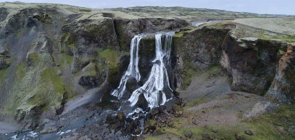
Fagrifoss – a beautiful waterfall next to F206 on a way towards Laki craters
There’s a big gravel car park next to Fagrifoss, where we even saw 2 buses parking (not both at one time). Most of the time, however, you should be here almost alone. It’s then a short 5-minute walk from the car park towards Fagrifoss via a paved path and a little gate (close it after passing). There’s even a viewing deck built over the waterfall, so you can enjoy it from a very nice viewpoint.
During our first visit to the waterfall, Fagrifoss was partially covered in the mist. The atmosphere was still very special though and I would recommend seeing it even in a partial fog. During our second visit to the waterfall, we didn’t have any fog and were able to see Fagrifoss and its surroundings in their entirety.
Laki craters – the main area
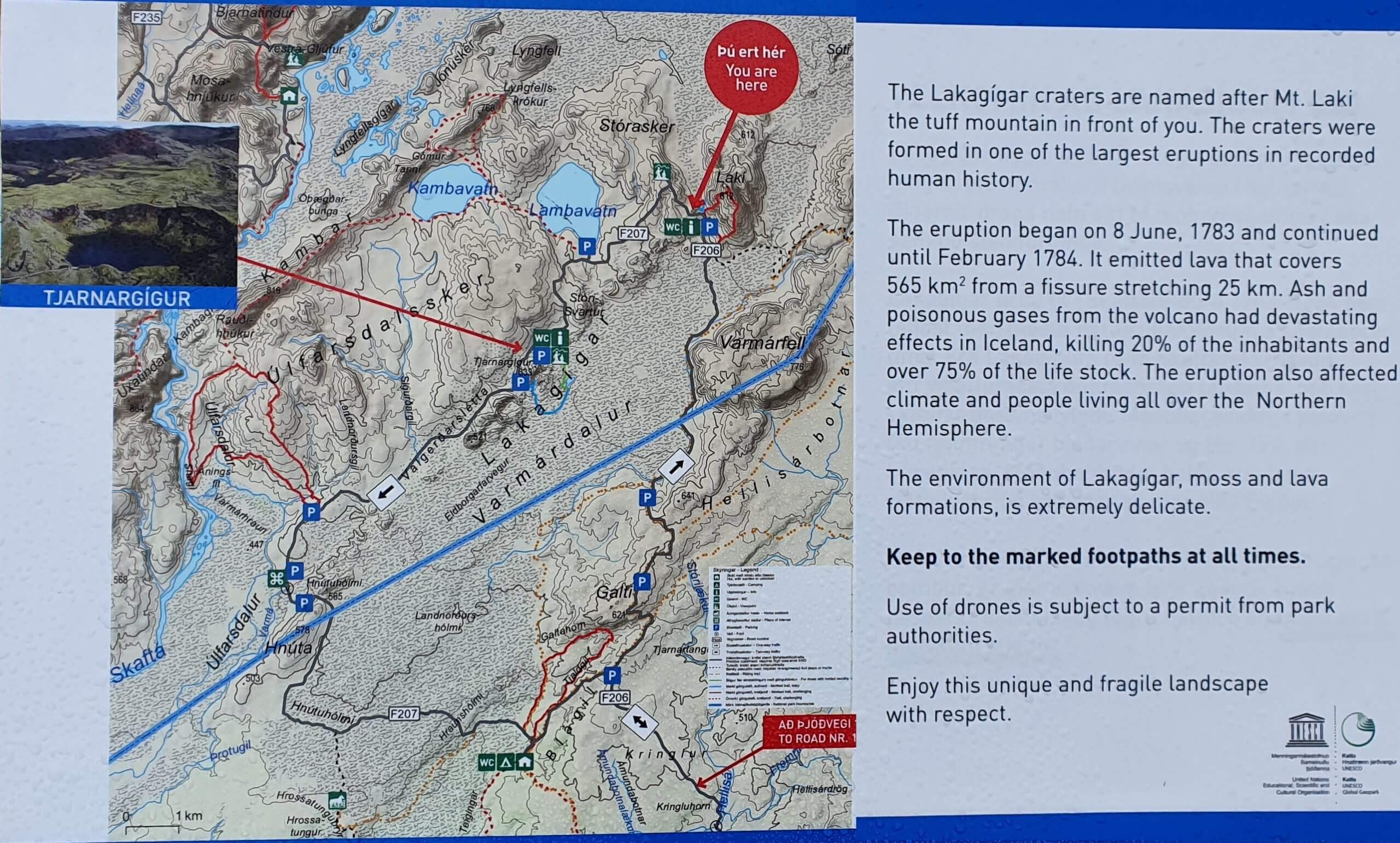
Laki craters area map
When I was planning the trip to Laki craters, I was struggling to find specific information about the Laki craters area. How big and long is the Laki area? What exactly is at Laki craters? How much time should we devote to Laki?. This is one of the reasons why I decided to write an article about it more in detail.
Once you reach the crossroads of the roads F206 (Lakavegur) and F207 (Lakagigavegur) you have arrived at the Laki craters area. The area is full of little old volcanoes, lava, ash, and moss. The circular road F207 leads around the area. The road is OK to drive through even in smaller SUV like Dacia Duster (during summer, if there are no weather alerts). There are some small car parks along the road where you may stop your car and take some pictures or just admire what you see.
F207 – Lakagigavegur
Except for these “car stops” there’s also the main Laki craters area. You will reach it the soonest if you turn right at the crossroads of F206 and F207 (which most visitors do). The main Laki craters area is located just below Mt. Laki. There’s a map of the area, ranger’s hut, toilets, and visitors’ center right below Mt. Laki. This is the main starting point to explore the area.
Laki crater hikes
The two main hikes in the Laki craters area are the visitors’ trail and the trail to the peak of Mt. Laki. If the visibility is good, I definitely do recommend you climb up the Mt. Laki.
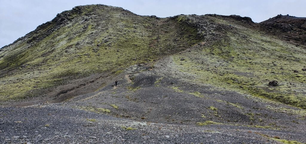
Mount Laki trail, a quick hike with some solid elevation
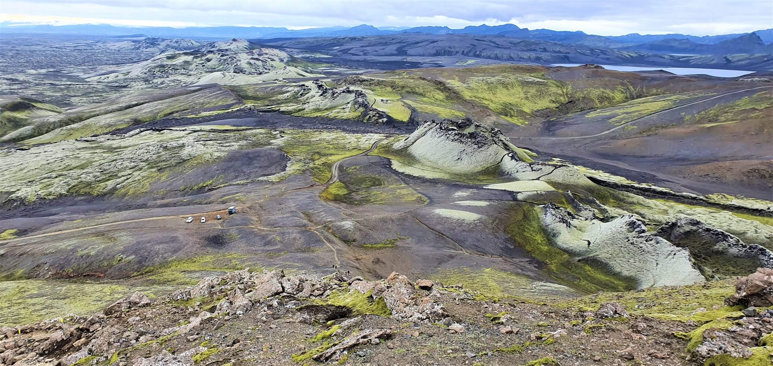
Mt. Laki
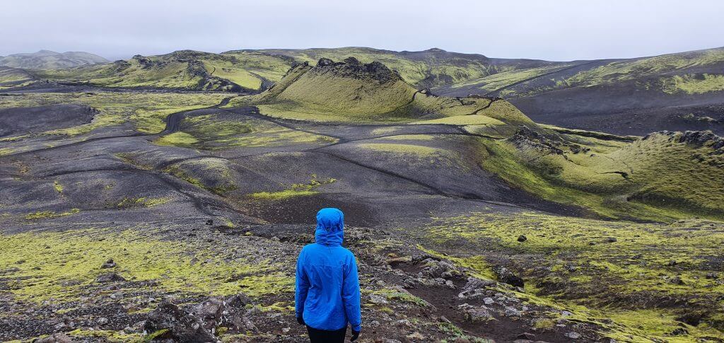
The views from the top of Mt. Laki are simply breath-taking. This was one of the most amazing places I’ve been to in Iceland. Looking at many small 200-year old eruptions from the bird’s eye perspective was a once-in-a-lifetime experience. The hike is a bit steep but short and not dangerous at all in a normal weather. There’s a well-marked path all the way to the top, which took us 15 minutes to complete at a quick pace.
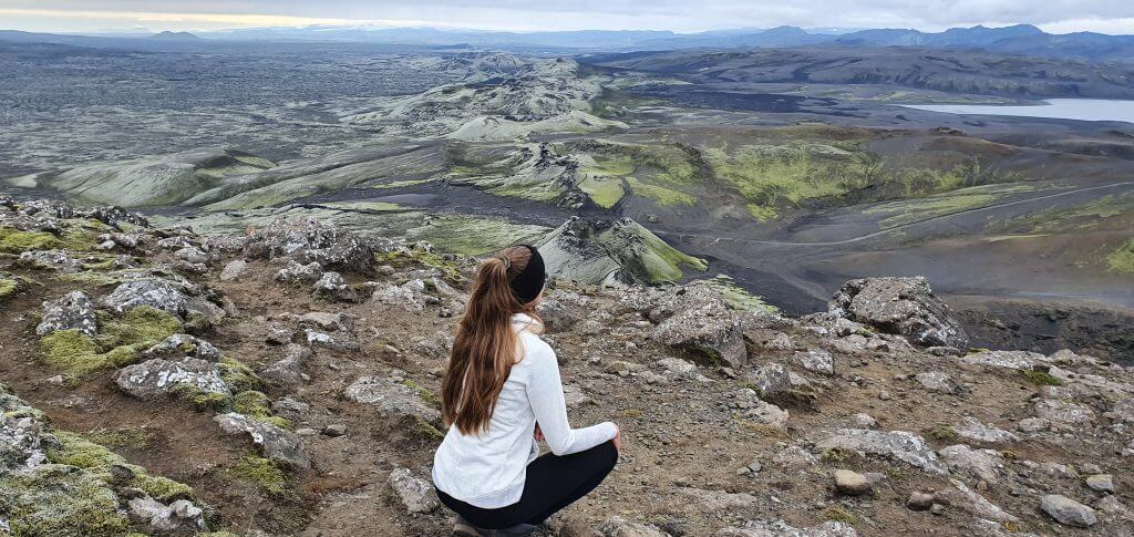
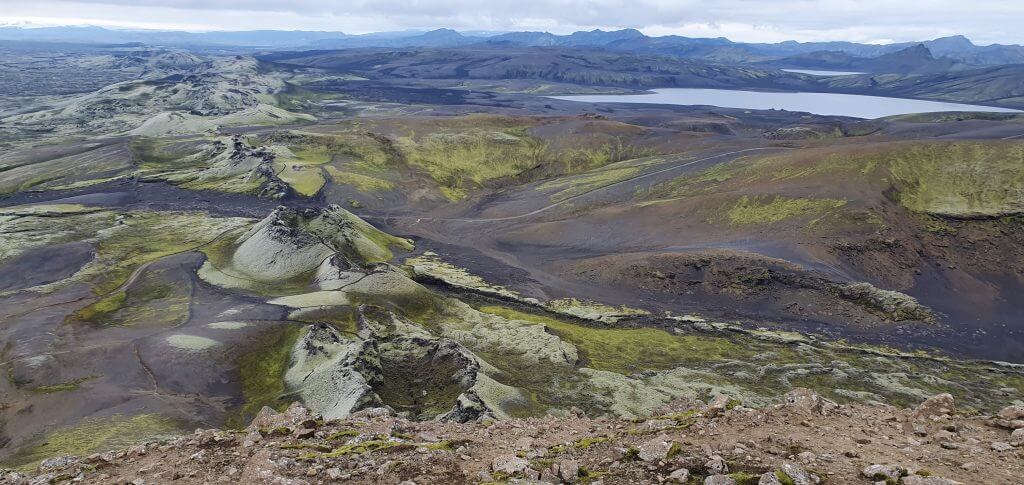
Mount Laki views
With each step up, the views are getting only better and better and once you reach the top you will be rewarded with an unbelievable 360~ scenery. During our first visit to the Laki craters we had foggy weather and little visibility, so climbing the mountain made no sense. However, we went for Mt. Laki also for the second time, during the good visibility and we don’t regret going there twice at all!
Visitors’ trail
The visitors’ trail was the second most interesting hike in our opinion. It’s a really easy 30-minutes long walk (rather than a hike) via out-of-this world little old volcanoes covered with green moss. It serves as an introduction to the entire area and has a unique atmosphere attached to it.
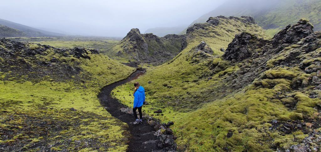
Laki craters visitors’ trail – the easiest hike
The Laki visitors’ trail begins a hundred meters left to the ranger’s hut and there’s a small car park right next to it. Thus, if you want to save 5 minutes, you may drive from the car park in front of the tourist center to this little car park right next to the trail.
Laki crater lakes
There are several lakes located in the Laki craters area. Two of them are easily accessible by car and/or walking and one of the Laki lakes (Tjarnargigur) is really picturesque (and recommended by rangers to visit).
If you continue in the counter-clockwise direction via F207, you will arrive at the Tjarnargigur lake on your left and at the Lambavatn lake on your right. There’s an improvised gravel car park in front of the Tjarnargigur lake where you have to leave your car and continue further by walking. On the other hand, you may drive all the way to the Lambavatn lake with your car.
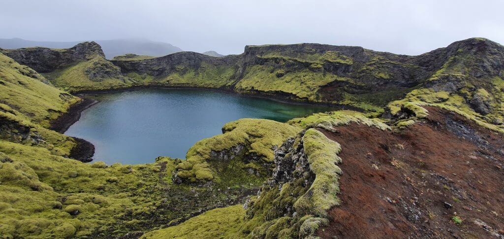
Tjarnargigur lake at F207 – a beautiful spot near Laki craters
It takes about 10 minutes of walking from the car park to arrive at the Tjarnargigur lake. We went there in light rain and foggy weather and the surrounding landscapes shined in the green color of the moss. The lake is very nice, peaceful and easy to visit. It, of course, is worth the little detour.
Our experience with Laki craters
During our first visit, this was one of the very few places in the south where it wasn’t supposed to rain all day. Yet, it was still foggy. We had to drive slowly and carefully all the way from Fjadrargljufur canyon, next to Fagrifoss to Laki craters. The visibility was bad, the roads narrow, twisty and full of gravel. In foggy and rainy weather, the drive is not that pleasant and feels a bit long. It’s still a surreal experience, though, given the beautiful Icelandic landscapes coming out of the mist from time to time.
F206, Lakavegur, in rain
We made a stop at Fagrifoss, being entirely alone there and enjoyed it in a partial mist. Yes, we couldn’t see it entirely clear, but still it was beautiful.
Then we continued towards Laki craters and crossed the only medium-sized river there without any problems (low water level at the time of our visit + adhering to river crossing rules). Soon after the river crossing, we arrived at the crossroads. This is where the Laki circle begins and road F207 – Lakagigavegur starts. You may continue in either of the directions, but most of the visitors (and us as well) go right first. If you turn right, you will reach the tourist information center (a.k.a. ranger’s hut) with toilets and map of the area after some 20 minutes long drive.
F207 to Laki in rain
At that time the crater area full of old lava popping out of the moss already starts to reveal in front of you. Once we arrived at the ranger’s hut, the ranger immediately welcomed us, showed us the map of the area, and suggested doing the short visitor’s trail and finishing the Laki circle of road F207. He also suggested making a stop at Tjarnargigur lake, which, in his opinion, is one of the most beautiful places in the Laki area. On the other hand, the ranger suggested not to climb Mt. Laki due to foggy weather and no visibility from the top.
Laki craters when it rains
We followed the ranger’s advice and went for the visitor’s trail located a few hundred meters left, up the hill, from the visitor’s center. Laki visitor’s trail is basically a nice, easy and short walk in between the old lava and little craters created during the Laki eruption in late 1700’s. It was an amazing experience even in foggy weather and light rain. Then we tried to climb at least a bit towards Mt. Laki and realized the ranger was right and we couldn’t see a thing as we progressed towards the peak. Hence, we decided to turn back, get into the car and continue towards Tjarnargigur lake.
Laki craters in rain (view from the Mt. Laki trail)
The F207 road is just a bumpy dirt road, without any huge obstacles so we drove it all the way to the Tjarnargigur lake without any problems. It’s roughly a 10-minute walk from the little car park towards Tjarnargigur lake. The lake is located in a very fragile vegetation environment, full of stunningly green moss, and once again has a pretty special atmosphere. Definitely worth making this short detour.
After the visit to the Tjarnargigur lake, we continued to finish the circular F207 Lakagigavegur. There we encountered our second medium-sized river crossing which was pretty similar to the first one and we didn’t have any problems with the ford. Short before the end of the F207, there’s even a small campsite where you may spend the night if interested in that. Not our case, we continued back via the same road F206 to Kirkjubaerklaustur.

There are 2 or 3 no-name roads other than F206 and F207 as detours from these roads which lead either west or east of Kirkjubaerklaustur. These roads are considerably less maintained, so we decided not to go for them this time and used the ordinary F207 and F206 to get back. Maybe next time.
Laki craters in nice weather
Two weeks after our first visit to Laki craters (which was really foggy and with an all-day-long drizzle) we decided to go see them again. We didn’t climb Mt. Laki on our first visit, due to the fog and no visibility at all. This time we wanted to climb it and see the views! We finished all our activities on that day at 4 PM and the weather was great. Thus, we made a quick decision to hurry up and headed directly to Mt. Laki. Laki-ly, by 6 PM we had our car already parked in front of Mt. Laki.
View from Mount Laki at Laki craters on a beautiful day
The hike to the summit is really quick in nice weather. And the views are more than just stunning. Seeing the earth “opening” in front of our eyes is an unforgettable experience. It was definitely worth it going to see Laki again in clear weather.
Laki craters Videos


![]() ask questions or get inspired in our community
ask questions or get inspired in our community


