
Iceland, often referred to as the “Land of Fire and Ice,” is a photographer’s paradise. With its otherworldly landscapes, dramatic weather conditions, and stunning natural beauty, this Nordic island country offers a plethora of photo opportunities that will leave you in awe. From the rugged highlands to the coastal wonders, here are the ten best photo spots in Iceland that should be on every photographer’s bucket list.
Contents
Map of Iceland’s Best Photo Spots
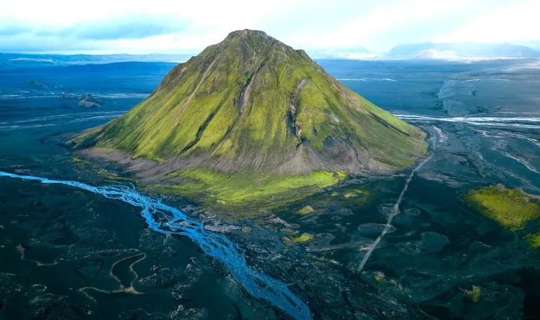
Thórsmörk
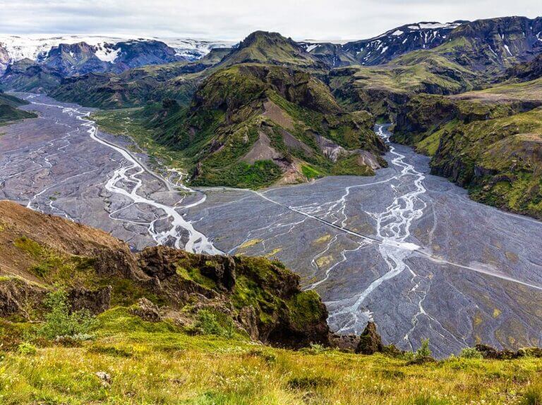
Þórsmörk, a magical Icelandic photo spot.
The Valley of Thor, or Þórsmörk in Icelandic, is a picturesque valley nestled between three glaciers: Eyjafjallajökull, Mýrdalsjökull, and Tindfjallajökull. It is named after the Norse god Thor, known for his fierce protection of the world against giants. The rugged beauty of this location certainly does justice to its namesake.
Why go
This enchanting location offers a unique blend of greenery, glacial rivers, and dramatic mountainous terrain, making it a captivating destination for nature photographers. It is also a popular hiking area. You can go on countless trails here. For example, the famous Laugavegur long-distance trail, which leads to the Landmannalaugar Nature Reserve, starts in Thórsmörk. Or the very famous Fimmvörðuháls hike.
How to get there
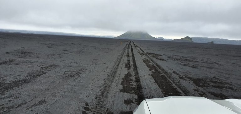
To reach Thórsmörk, you’ll need a 4×4 vehicle, as the roads can be challenging. Thórsmörk lies about 140 km east of Reykjavík, but the last 20 km is on a dirt road with several fords, which is passable only by off-road vehicles.
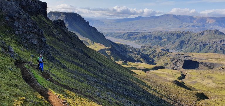
The final part of the Fimmvorduhals hike near Thorsmork
The journey typically begins from the small town of Hvolsvöllur, taking you through river crossings and rugged tracks. Guided tours are also available for those who prefer a hassle-free experience.
Tips on visiting
- If you don’t feel like taking a car, you can also use the tourist buses from Reykjavik or Hella. Return tickets cost around 14,500 ISK, and you can use companies such as Reykjavík Excursions or Trex. These special four-wheel-drive mountain buses run around three times per day during summer.
- Plan your trip during the summer period from June to September. During winter, the road to Thórsmörk is impassable and closed as crossing the rivers gets very dangerous. Even during summer, only experienced drivers should drive there as the weather conditions can change within minutes.
- At the bottom of the valley, you can stay in the beautiful rural guesthouse Volcano Huts Þórsmörk or camp at Thórsmörk campsite.
Askja
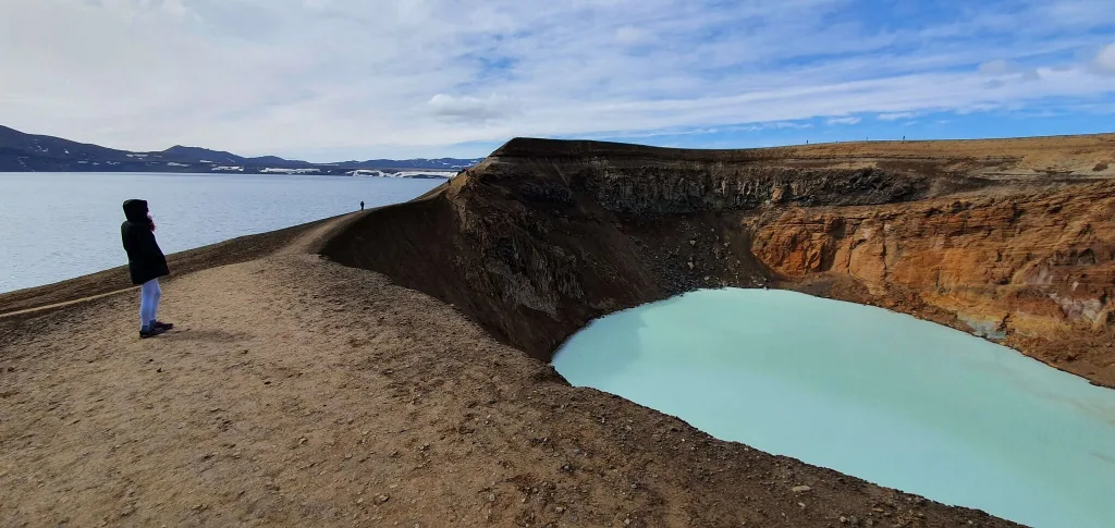
Our visit of the Askja volcano area, one of the best places for photography in Iceland
Askja is a 4 km-long volcanic crater located in the remote and desolate highlands of Iceland. Photographers are drawn to this otherworldly destination for its lunar-like landscapes, including the Viti crater, filled with a striking turquoise geothermal lake. It’s an ideal location for capturing the raw power of Iceland’s geological forces.
Why go
The area around Askja is one of the most remote parts of Iceland. The barren, monotonous landscape with only shades of grey, brown, and black resembles more than any other place the landscape on the moon. The monotonous yet extremely beautiful landscape takes you to an exotic nature like you won’t find on the European continent. That was one of the reasons why NASA chose the Askja area for the geological training of its astronauts before going to the Moon.
How to get there
Getting to Askja is an adventure itself. You’ll need a sturdy 4×4 vehicle and a sense of adventure, as the F-roads leading to Askja can be challenging. The journey usually begins from the Dettifoss area in the northeast.
Directly below Askja is the F910 road, which leads off the F88 road. It then connects to the main Ring Road number 1.
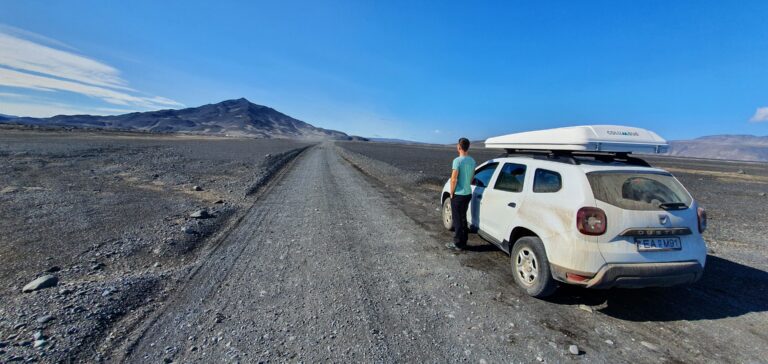
F905 to Askja on a gorgeous sunny summer day
The distance from Reykjavik is 603 km. The roads are only passable for jeeps for a few months of the year, from early June to mid-September, when they disappear under a layer of snow and ice. The weather is unpredictable in this area, so it is vital to plan your journey well and check the current weather conditions.
From the car park at the end of the road, a hiking trail about 2.5 km long leads to the crater rim and Lake Öskjuvatn.
Tips on visiting
- Pack a swimsuit for the trip! You can even swim in the Askja Crater. Thanks to the geothermal springs, the water temperature is very pleasantly warm (around 28 °C) and can come in handy in colder weather.
- The whole area of the Icelandic highlands is breathtaking. Plan your trip and enjoy your time in this area. However, always check the current safety conditions. Hiking can be fun and enjoyable in good weather, but you don’t want to experience bad weather in this area.
Maelifell
Maelifell volcano is one of the most picturesque places in Iceland away from the crowds.
The green, cone-shaped mountain rising above black sand. That’s Maelifell Volcano, located in the Iceland Highlands, just northeast of the massive Mýrdalsjökull Glacier Park.
Why go
Maelifell is a mesmerizing natural wonder featuring a perfectly cone-shaped volcano covered in vibrant green moss. This surreal landscape creates a captivating contrast with the surrounding black sand desert, making it a fantastic spot for photography.
The vibrant green moss that blankets Maelifell is a type of moss called Racomitrium lanuginosum, and it’s an essential part of Iceland’s delicate ecosystem.
- Interesting fact: Maelifell has been featured in films such as Noah and television series such as Game of Thrones because of its beauty.
How to get there
F210 Fjallabaksleid Sydri east to Maelifell
From Reykjavik, you take the Ring Road to the south. In Hvolsvöllur, turn left onto Route 261, which will become F261. Continue this road until turning on F210, which leads you to Maelifell after approximately three and a half hours of driving. You can access the site also from the east, starting on F208 and continuing on F210.
A 4×4 vehicle is essential, and it’s best to visit during the summer months when the roads are more accessible. During winter, the roads leading to the highlands are closed due to snow. Attempting to cross them is dangerous.
Tips on visiting
- Even during summer, the terrain of the roads is very challenging, bumpy, and involves crossing rivers, so prepare to challenge your driving skills. Always check road conditions beforehand.
- Enjoy the view on the black sands to Maelifell from the summit of Rauðibotn, a colorful volcano that lies near the F210 from the east.
Westman Islands
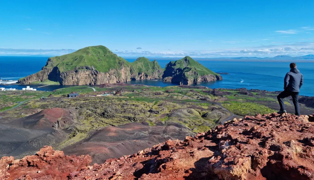
Eldfell volcano hike is one of the easiest and most beautiful ones
The Westman Islands, or Vestmannaeyjar, is a group of islands located about 12 kilometers off the south coast. Heimaey is the only inhabited place on Vestmannaeyjar.
The area is known for its remarkable history, including the eruption of the Eldfell volcano in 1973, which led to the evacuation of the entire population of Heimaey, the largest island in the archipelago. The town has since been rebuilt, and the eruption created new and unique landscapes worth photographing.
Why go
Heimaey is a bit of a hidden gem of Iceland. It offers a unique blend of natural beauty and wildlife photography opportunities. With dramatic cliffs, puffin colonies, and breathtaking coastal vistas, this place is heaven for photographers looking to capture the beauty of Iceland’s coastal landscapes.
- Interesting fact: Westman Islands are considered the largest Atlantic puffin colony in the world.
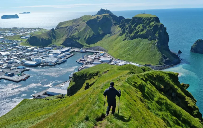
Views from Heimaklettur on Heimaey island
How to get there
You can reach the Westman Islands by taking a ferry from the mainland, departing from the town of Landeyjahöfn in the south of Iceland. The ferry ride itself offers scenic views. The main island is not very big, so it can be explored on foot, or you can try to hitchhike. Taking a car is not necessary, but it is more convenient, especially if you want to save time.
Tips on visiting
- Visiting the Westman Islands is a perfect one-day trip from the mainland. If you really want to enjoy the beauty and landscapes of the island, plan a trip at least two days long. That way, you will have time to experience a unique atmosphere.
- Heimaey offers many hiking routes with amazing scenic views of the ocean and surrounding islands.
Jökulsárlón Glacier Lagoon
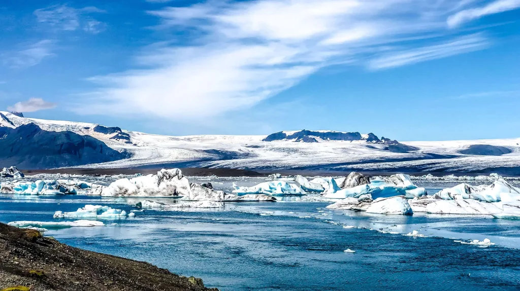
Jökulsárlón glacier lagoon
One of the most famous tourist spots in Iceland attracts travelers from all over the world. The overturning and cracking glaciers of Jökulsárlón create an incredible atmosphere. You might see the area as a backdrop for numerous movies, including James Bond’s “Die Another Day” and “Batman Begins.”
Why go
Jökulsárlón Glacier Lagoon is a surreal and ethereal location where massive icebergs break off from the Breiðamerkurjökull glacier and float serenely on the lagoon’s icy blue waters. This icy wonderland is a dream come true for photographers seeking to capture the magic of glacial landscapes.
Not very far away from the lagoon, glacial fragments of various sizes enter the ocean. They are either carried by the waves or remain trapped on the black sand beach, creating such a unique and magical spectacle. No wonder the beach was named Diamond Beach.
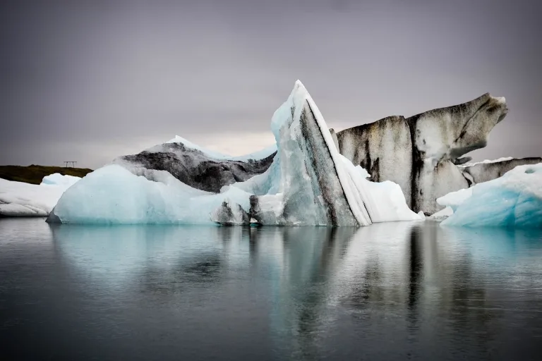
Jökulsárlón
How to get there
Jökulsárlón is easily accessible from the Ring Road (Route 1) in the southeast of Iceland. It’s a popular stop for travelers exploring the South Coast.
Tips on visiting
- Jökulsárlón Glacier Lagoon is a popular tourist destination. The place might be crowded, especially during summer. There is a big car park with a parking fee to access the lagoon area.
- Not enough to admire the glaciers from the coast? Take one of the boat tours that will take you closer to the icy pieces. You might see some seals as well.
- Plan the visit during sunset to get different light for your photos.
Landmannalaugar
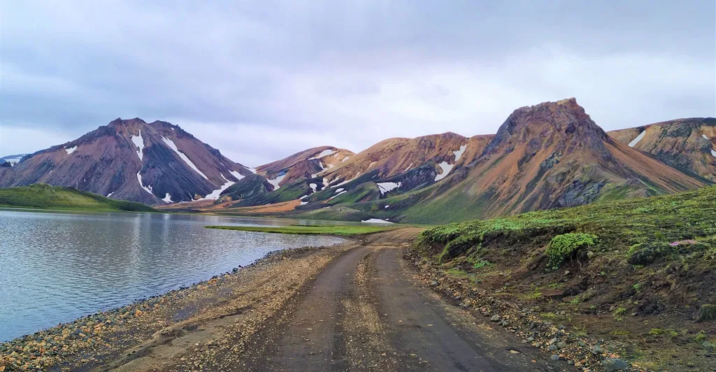
Landmannalaugar is an iconic photo spot
Landmannalaugar is a must-see place located in the heart of Iceland’s highlands. You can go there for a one-day trip or challenge yourself and set out a multi-day hiking route. There is a starting point of the Laugavegur Trail that takes you closely through some of Iceland’s most diverse landscapes, including colorful mountains, black deserts, and lush valleys.
Why go
It is a geothermal wonderland filled with vibrant rhyolite mountains, hot springs, and bubbling mud pots. The kaleidoscope of colors and unique geological features make it an enticing destination for photographers and hikers.
How to get there
To reach Landmannalaugar, you’ll need a 4×4 vehicle, and it’s usually accessible during the summer months via the F-roads. You can also join guided tours that depart from Reykjavik.
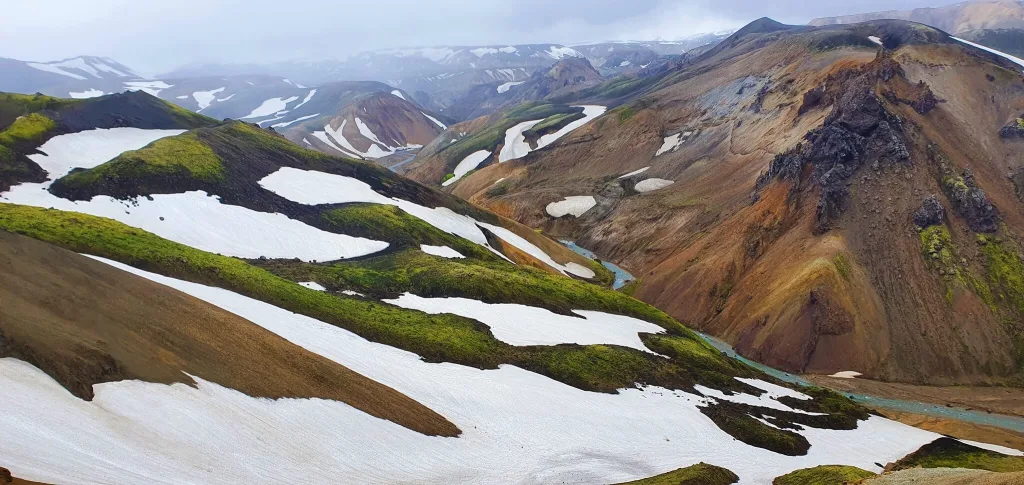
Rainbow hills on a Grænihryggur hike are some of the most beautiful ones in Landmannalaugar
There are three main roads leading to the campsite:
- From Reykjavik on the F32 and the gravel road, F208.
- From the west of the Hekla volcano, the gravel dirt road F26 and then F225 leads, which is passable only by off-road vehicles, among other things, because of several fords.
- From the east along the F208, a dirt road in good condition. However, you must cross about 15-20 fords on the way and, therefore, it is passable only by 4×4 off-road vehicles.
Tips on visiting
- All marked trails start at the large Landmannalaugar campsite, where you will also find public toilets, a small shop, and parking. There are six main trails leading from here, but you can combine them freely. They are marked with low-colored stakes, but you may not come across any signs for miles. The trails include both easy and short ones and long and challenging ones.
- Before visiting, check the road conditions and river level. The road is only opened in the summer, starting mid-June to mid-September.
Seljalandsfoss
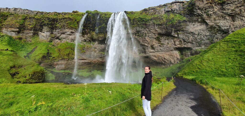
Seljalandsfoss at 7pm
Seljalandsfoss is one of Iceland’s most iconic waterfalls located in the south of Iceland. You can see it from a distance while driving the Ring Road, which makes it accessible all year around.
Why go
Seljalandsfoss is popular because of its location and its unique feature: you can walk behind the cascading water curtain, providing a rare and awe-inspiring perspective for photographers. Capturing the waterfall from behind, with the Icelandic landscape in the background, creates stunning and memorable images.
How to get there
Seljalandsfoss is conveniently located along the Ring Road (Route 1) by the South Coast. It’s easily accessible by car. From Reykjavik, it is 1 hour 45 minutes long drive.
Tips on visiting
- Seljalandsfoss is one of the most visited places in Iceland. Plan the trip outside the season, early in the morning, or enjoy long summer nights and visit it during the night to avoid crowds.
- It’s probably no secret nowadays, yet many people skip it in their haste. We’re talking about the neighboring Gljufrabui waterfall. It is cleverly hidden in the rock just a few hundred metres further along the path to the north. Waterfalls are usually magical places, but cave waterfalls are even more magical, offering unique photo-shooting opportunities.
- There is a car park next to Seljalandsfoss for a small fee. You’ll find public toilets and souvenirs as well.
Kirkjufell
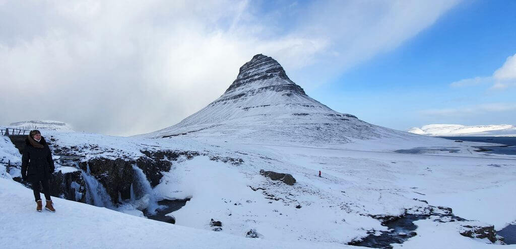
Kirkjufell in winter makes for an epic place for photography
Kirkjufell, also known as “Church Mountain,” is an iconic mountain lying on Snæfellsnes Peninsula in western Iceland.
Why go
Kirkjufell Mountain is perhaps one of the most photographed landmarks in Iceland. Its distinctive shape, paired with the nearby Kirkjufellsfoss waterfall, creates a stunning composition, which is perfect for photographers looking for that iconic shot.
How to get there
The area is easily accessible by car. It is around 180 kilometers from Reykjavik, which is about 2.5 hours long drive. Both the mountain and waterfall are located next to the main road 54. Right next to the mountain, you will find a small paid parking lot.
Tips on visiting
- You can climb the 463-metre-high mountain on a very steep trail.
- Snæfellsnes Peninsula is a gem bit forgotten by tourists. Not many people include the peninsula to their travel itinerary, but you should. It is full of natural beauty, iconic churches, waterfalls, glaciers, and picturesque lighthouses.
Goðafoss
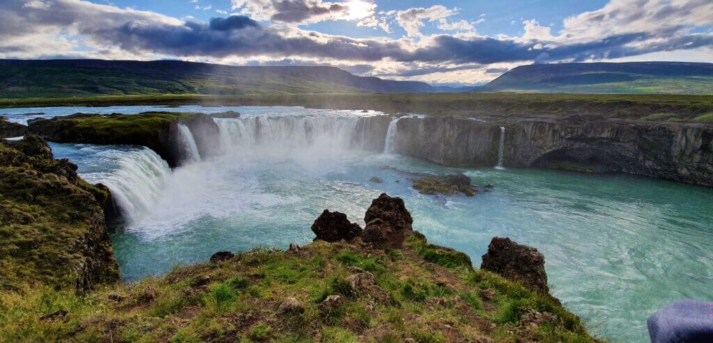
Godafoss before sunset
Goðafoss is a waterfall in the north of Iceland between the Akureyri and Mývatn area, often referred to as the “Waterfall of the Gods. The nickname originates from an ancient tale when Iceland converted to Christianity, and the local chieftain Thorgeir Ljosvetningagodi threw his statues of Norse gods into the waterfall, symbolizing the shift in the nation’s beliefs.
Why go
With a width of over 30 meters and a wide horseshoe shape reminiscent of Niagara Falls, it is one of the most beautiful Icelandic waterfalls. It is also easy accessibility to both sides of the waterfall; you can practically walk right to the water and enjoy the monumental water spectacle up close.
How to get there
Goðafoss is easily accessible by car and is located along the Ring Road (Route 1) in northern Iceland, making it a convenient stop for travelers exploring this part of the country. The waterfall is visible from the road, and a short walk leads you to various viewpoints for photographing its splendor.
Tips on visiting
- The waterfall can produce a lot of mist, so protect your camera gear.
- There are a lot of different paths around the waterfall, allowing you to enjoy it from all angles. One path leads down to the water, and the view of the waterfall from below in all its glory makes it even more monumental.
Vestrahorn
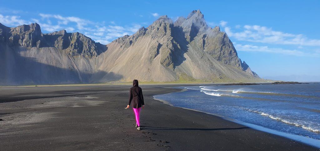
Vestrahorn in Stokksnes proudly belongs to Iceland’s top photo spots
Vestrahorn is a striking mountain located on the Stokksnes Peninsula in southeastern Iceland.
Why go
Vestrahorn is a favorite spot of photographers for its dramatic, almost surreal appearance. With its jagged peaks, black sand dunes, and reflective lagoon, Vestrahorn offers a diverse range of photographic opportunities, making it a must-visit destination for landscape enthusiasts.
How to get there
Vestrahorn is easily accessible by car from the town of Höfn in southeast Iceland. The mountain is visible from the main road (Route 1), and you can drive to the base of the mountain. The Stokksnes Peninsula is private land, so there’s an entrance fee to access the area, which also includes a café and facilities.
Tips on visiting
- If you want to capture the iconic reflection of Vestrahorn in the lagoon, visit during high tide when the water creates a beautiful mirror effect.
- A few metres from the car park, there is a man-made Viking village, which was built as a prop for a film that was never finished.
- Due to the close proximity to the sea, the mountains are very steep, and there are no official trails leading to them. However, you can hike up to the heights on beaten paths, which offer spectacular views of the black and grey slopes and the ocean.


