Graenihryggur hike is one of the most beautiful hikes in Landmannalaugar with stunning views full of spectacular colors. Grænihryggur is also one of Iceland’s best-kept secrets with almost no visitors even during the peak season! It’s a longer and more difficult hike but well worth the effort, making it a once-in-a-lifetime hiking experience.
Contents
So what is Graenihryggur? The literal translation would be a „green ridge“. And this is precisely what makes Grænihryggur special. Out-of-this-world blue-greenish color. It’s a ridge well hidden deep in the Landmannalaugar mountains. It can’t be seen from typical touristy hikes in Landmannalaugar, like Bláhnúkur or Brennisteinsalda.
Icelandic locals know well about Grænihryggur and they are usually the only visitors you will meet on a trail. Besides locals, guided tours also head to Graenihryggur, because this is one of those places in Iceland that can still be considered a true „hidden gem“.

Hike in a nutshell
Graenihryggur hike is an 8km long out-and-back hike that takes about 8 hours to complete. It is moderately difficult with some steeper and slippery parts and is accessible only in summer. It is one of the most beautiful hikes in Iceland, still not known to many visitors.
Location: 7km south of Landmannalaugar campsite detour
Length: 8km (5mi) one way, 4 hours one way
Difficulty: moderate to difficult
Season: typically from July to September
Gear: hiking shoes, hiking poles, rain-proof, and wind-proof clothes
Hiking trail: coordinates of the hiking trail
How to get to the Graenihryggur hike
Graenihryggur is located in Landmannalaugar, close to the campsite. There are several different ways to reach Graenihryggur hiking trails and none of them is trivial. Firstly, you need to reach the famous Landmannalaugar area. For that, you have the 3 options below.
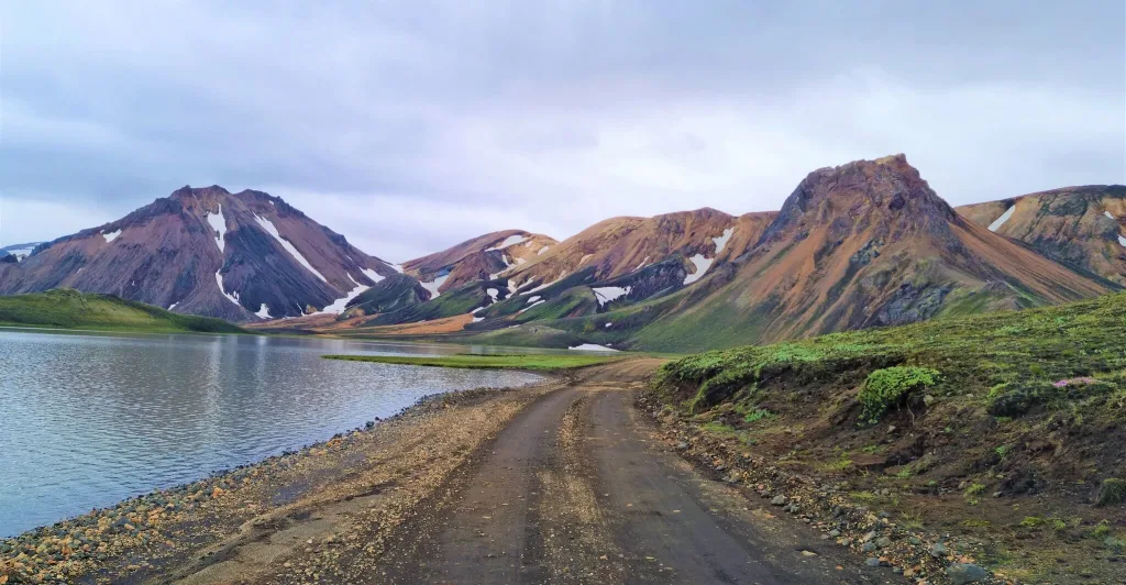
Amazingly beautiful roads around Landmannalaugar
Getting to Landmannalaugar
You can get to Landmannalaugar via three different roads:
- Road 208/F208 from the North – no river crossings, bumpy road, the easiest, not very interesting
- Road F225 from the West – small river crossings, nice road, the shortest, medium difficulty
- Road F208 from the South – medium river crossings, the most beautiful, the most difficult
We explained in detail the differences between these three roads in our Guide to Landmannalaugar. You need to have a 4wd car when heading to Icelandic Highlands and Landmannalaugar. A medium-sized 4×4 car is the best for this type of trip.
Getting to Grænihryggur trailhead
There are two main trailheads leading to Graenihryggur from Landmannalaugar. The first, shortest, and most popular trailhead is located right next to road F208, close to Landmannalaugar campsite, 8 kilometers (5 miles) south of road F224. It is depicted on the map above and also zoomed in the picture below.
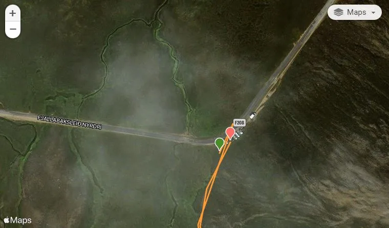
Grænihryggur trailhead map. Source: Wikiloc
The second trailhead is located at the Landmannalaugar campsite itself, where all famous Landmannalaugar hikes start. For our hike, we chose the first option – the so-called Halldórsgil trail. Halldórsgil is the most popular and also the shortest and safest trail leading to Grænihryggur. It leads via Halldórsgil canyon. The other trails are difficult, dangerous, and barely marked, see below.
Grænihryggur hiking trails
Graenihryggur is located in the heart of Landmannalaugar, between Brennisteinsalda campsite and Hrafntinnusker hut. This means you can get to Graenihryggur by many different trails, none of them being short, nor easy, though. Several of these trails are not even marked, that’s why many choose a guided tour instead of a self-hike.
Map of the Grænihryggur hiking trails:
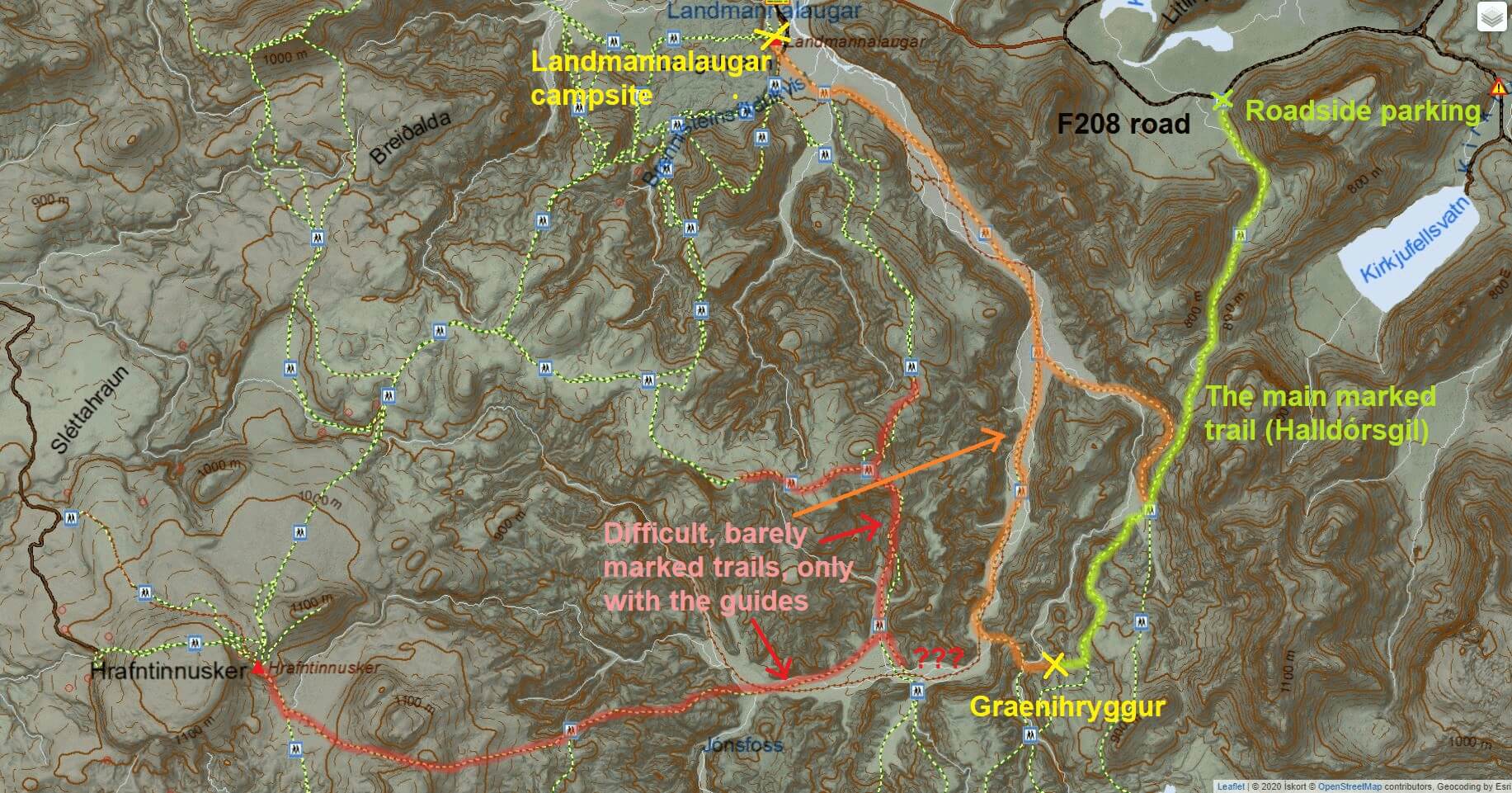
Map of the Grænihryggur hiking trails
There are three known hiking trails to Grænihryggur:
- The main Halldórsgil trail. It starts as a hike through the canyon of Halldórsgil. Halldórsgil trail is a well-marked trail (red sticks). This is the shortest, easiest, and also most popular trail. The only disadvantage of the Halldórsgil trail is that it’s an out-and-back trail. Landscapes around the trail are more than just amazing. We took this trail and describe it in detail below. It took us roughly 6 hours to complete a round-trip.
- The Landmannalaugar trail. The second, significantly longer, more difficult, and unmarked trail is a loop trail from Halldórsgil, via Grænihryggur to Landmannalaugar campsite and back (or the other way around). After reaching Graenihryggur you have to climb up and down several steep and unmarked ridges and also ford the fast-flowing and wide Jökulgilskvísl river. We highly recommend doing this hike only as a guided tour, or only if you are a very experienced hiker and you are in luck with a great weather forecast (no fog, rain, or strong winds). The Graenihryggur Landmannalaugar loop takes about 10-12 hours to complete.
- The Hrafntinnusker trail. Apart from the two main Grænihryggur trails mentioned above, you may also hike to Graenihryggur by several different combinations of various trails in the area. Most of them are longer and more difficult than those we mentioned above. Hikers usually hike them as a part of multi-day Landmannalaugar hikes. In addition, the majority of them are unmarked.
Map of the Graenihryggur hike
Below is the detailed map of the main Grænihryggur hike, the Halldórsgil hike. There are the exact coordinates of the hike as we’ve done it in late July. All necessary info such as altitude, hiking times, and the trail we took are included in the interactive map below:
Hiking difficulty
- The hike is considered to be a moderately difficult hike.
- The main danger of the hike lies in unpredictable weather, a very remote area with no network coverage and slippery trails
- It is a full-day hike, it takes 7 to 9 hours to complete it as a round trip.
- There are no chains, nor very exposed parts, yet some of them are steep
- Many steeper parts are made of small gravel or dirt and the grip is not the best, especially if it rains
- There is one river crossing, a wide Jökulgilskvísl river, not very deep; it is possible to cross it on dry feet in dry weather, however, you may need to wade it when there’s more water in the river;
- It’s a great hike for anyone with hiking experience, even for families experienced in hiking;
- It’s NOT a hike for the elderly or small children, or anyone used to just hiking for 1 hour and no more
- Take special care early in the season (June/July), there may be snow bridges with dangerous rivers under them!
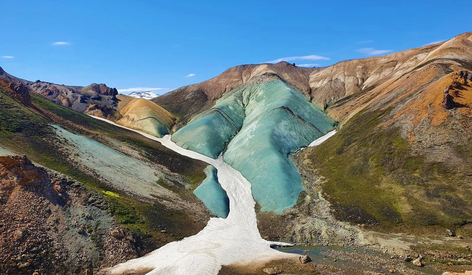
Unbelievable Grænihryggur hike views
When to hike Graenihryggur
Typically, you can go for the hike any time between the beginning of July and mid-September. Similarly to when F-roads are open, the hike is accessible when there’s no considerable snow on the trails. This usually starts in July, once most of the winter snow has melted, and ends at the end of September when the new snow arrives.
Of course, there are exceptions to the general rules mentioned above. After mild winters, you may be able to hike Graenihryggur even in June and maybe even until October. On the other hand, after very tough winters, you may encounter huge amounts of snow on trails even in July or August. This is exactly what happened to us in late July. The amount of snow was bearable, though, so we could just hike over it and not get stuck in it.
If you are unsure about the current conditions of the trails, it’s always best to contact SafeTravel.is by email, or to ask a local. One last important thing – even in summer, always check the weather forecast before the hike. Don’t hike during strong rain or strong wind, it can be very dangerous. Skies don’t have to be clear, but at least aim for no heavy rain or wind. We also wrote a handy guide on How to find nice weather in Iceland.
Grænihryggur hiking trail
How to prepare for the hike
- Wear proper hiking shoes, wind-proof, and water-proof clothes (not just repellent!)
- Have a winter hat and gloves ready if it’s too chilly
- Hiking poles are a big plus, although it’s possible to hike also without them (not recommended)
- Check the local weather forecast, and read tricks on how to manage weather; Go only if it doesn’t rain or blow too much; Ideally no rain at all
- Check road conditions; you are looking for the green color
- Better rent a satellite location device if you are not in a big group or not with a local
- Bring wading shoes and a little towel for river crossing
- Crampons are not necessary during the main season (July to September) and they won’t help either outside of the season (just don’t go)

One of the countless picturesque spots during the hike
The main hike – our experience
We drove by the Graenihryggur Halldórsgil trailhead on a cloudy, rainy, and foggy day. Definitely not an ideal day for a hike. We were indecisive about whether to go for the hike or not until the very last minute. Finally, my cousin co-hiker persuaded me to give it a try. And I’m now glad he did because the weather actually improved and the hike was amazing even without sun and clear skies!
We reached the starting point of the trail by our modified Land Cruiser around lunchtime, so pretty late. That was also the reason why we didn’t speculate with longer, unmarked trails, and rather stuck to the classic marked Grænihryggur trail from Halldórsgil canyon. The Halldórsgil trailhead is located just a few minutes of a drive south from the crossroads of F224 and F208.
There’s no car park, but we recognized the trailhead thanks to around 6 local Icelandic cars being parked at the edge of the road. These were apparently no tourists, but locals. We parked our car as the last one in the row, packed our backpacks, and headed out into moody weather.
Graenihryggur hike trailhead -the beginning of the hike via Halldórsgil
Halldórsgil canyon trail
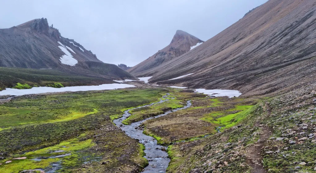
The first part of the trail to Graenihryggur is the easiest and also the most boring part of the hike. It leads via Halldórsgil canyon, which is one of the less magnificent Icelandic canyons, yet definitely a peaceful one. You won’t meet many fellow tourists here, as I already mentioned.
We hiked to Grænihryggur in July, in a year of a very strong Icelandic winter. This means we encountered a lot of snow on the trail, even in the second half of July. Soon into the hike, we reached smaller snowfields that got bigger and bigger the further we proceeded with the hike. Some of these snowfields were a bit scary. At one moment we could see a flowing river right under the melting snowfield and we had to walk through this snowfield, hoping not to fall down through it.
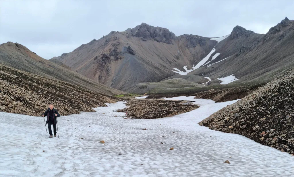
Snowfields in July on the Halldórsgil canyon trail to Grænihryggur
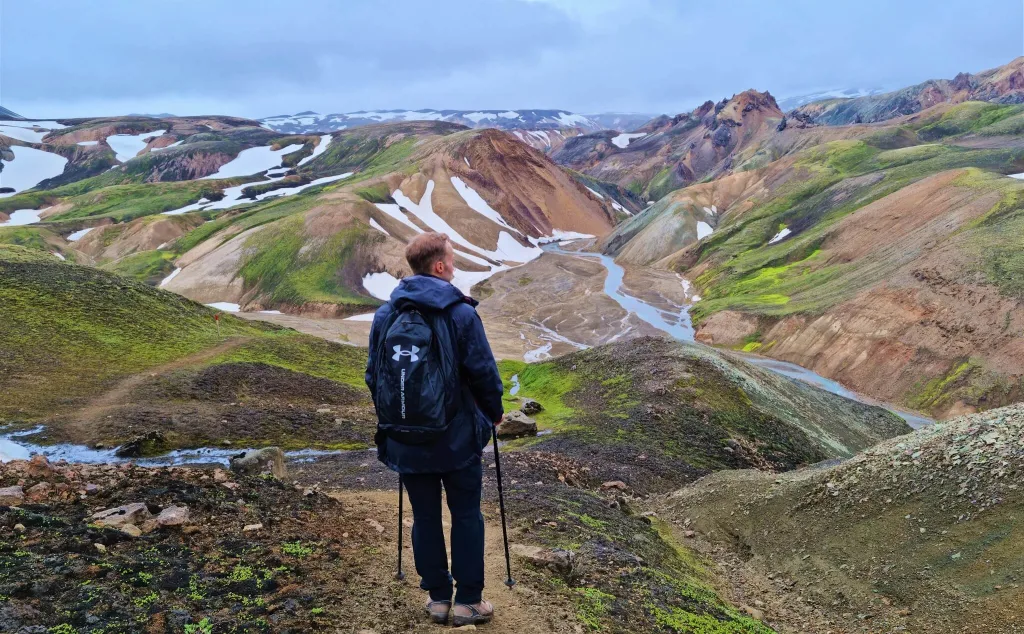
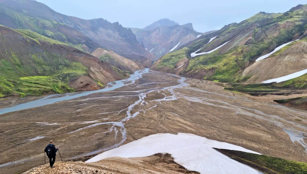
The ascent was gradual and there were no technical parts in this section of the hike. There was just a lot of walking in the snow, which is naturally more tiring compared to firm terrain. After about an hour of hiking, we stumbled upon the first of many amazing viewpoints. We finally got high enough to be able to observe the monumental Halldórsgil valley from the bird’s eye viewpoint. This is the typical Grænihryggur hike moment – Landmannnalaugar, but different, more remote, and even more magical, everywhere around you.
Crossing Jökulgilskvísl river
After reaching the highest point of the trail, what follows is at times steep and slippery descent all the way down to Jökulgilskvísl river. And yes, you have to cross the Jökulgilskvísl river. Luckily, at the time of our visit in July, it was possible to cross the river with dry feet. The reason is, this is not the main riverbed, it’s just an arm of Jökulgilskvísl. Or better said, many small arms.
Graenihryggur river crossing of the river Jökulgilskvísl on our way back
We were able to either hop over some of the river arms or we found some shallower spots where our shoes didn’t get wet, or we managed to find some stones suitable for hopping through. This fun can actually take some time. At least we were able to cross it with dry feet, unlike the river in Vonarskarð.
Now maybe you can guess what follows after this descent? Yes, you’re right, another ascent! And once again slippery and at times steep. This is one of the reasons we don’t recommend hiking Grænihryggur during/after a strong rain. Trails can get wet and even more slippery, and trust me, you don’t want to hike steep trails with mud all over the trails.
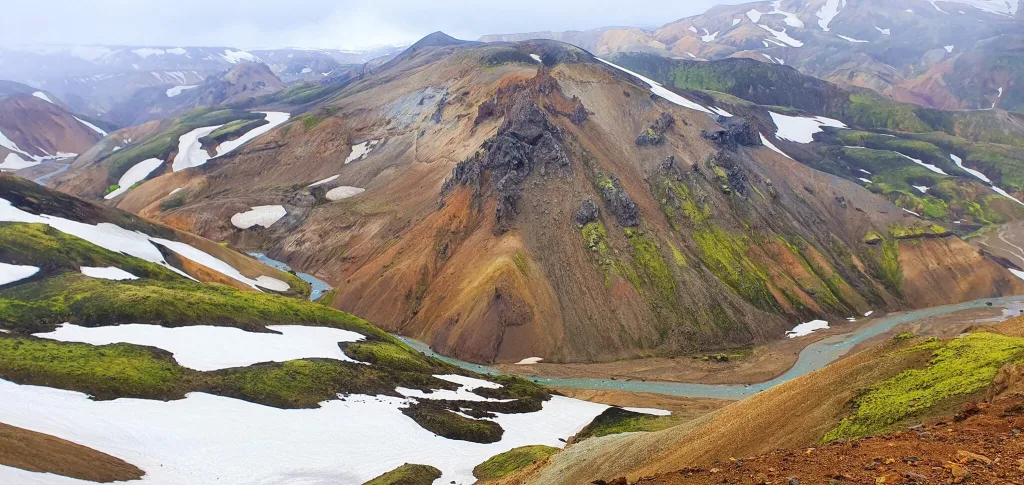
Rainbow hills
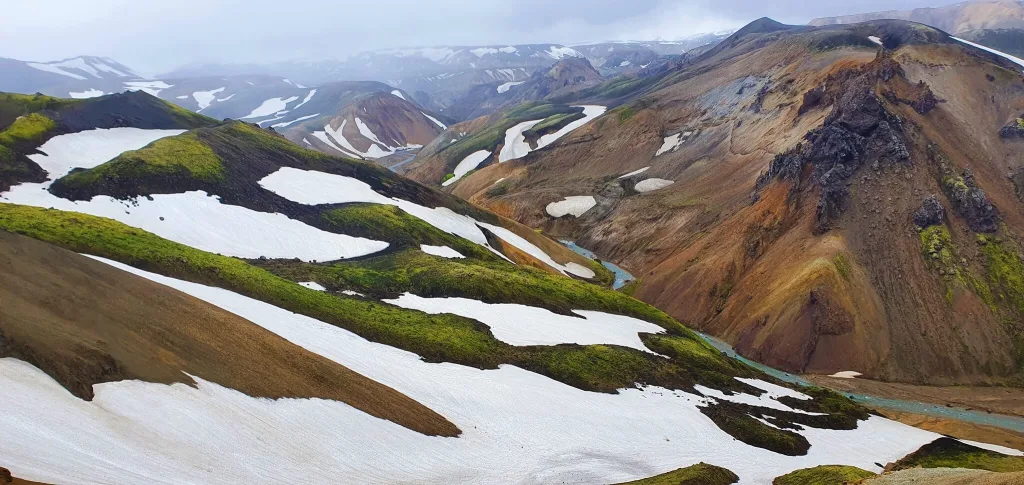
Rainbow hills on a Grænihryggur hike are some of the most beautiful ones in Landmannalaugar
Despite being a bit more difficult, the hike to Grænihryggur is strikingly beautiful! Most of the time you’re gonna be surrounded by various types and tones of rainbow mountains, feeling totally like in a fairy tale. The weather was far from clear skies during our hike, we nevertheless felt like on another planet anyway.
Shortly before the final ascent of the hike we met the local Icelandic hiking group, which seemed to be just a huge group of friends. At that moment we saw who came with all these local cars 🙂 The group was apparently enjoying their summer hike and making a little picnic with some amazing views over nearby rainbow hills.
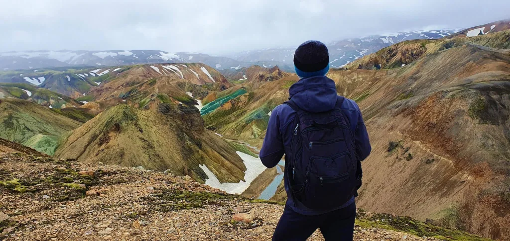
The first glimpse of the green ridge in the distance
Nevertheless, we continued with our hike and eventually reached the plateau, where we could finally see the famous Grænihryggur in the distance! Visibility wasn’t ideal, and Grænihryggur definitely looked much better in reality compared to the pale colors in the pictures. But that’s Iceland! We were happy we caught only a slight drizzle and weak fog and conditions were otherwise nice.
From this point we could already see Graenihryggur in the distance, so we could have easily ended at this spot and turned back, but we wanted to arrive right next to this famous green ridge. That being said we continued further along the trail.
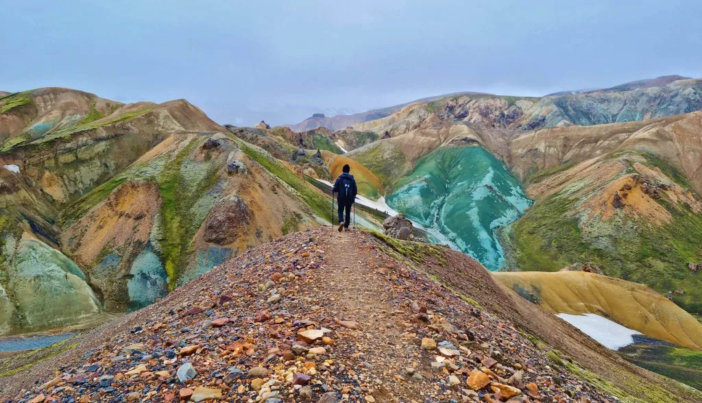
The final descent towards the green ridge of Grænihryggur
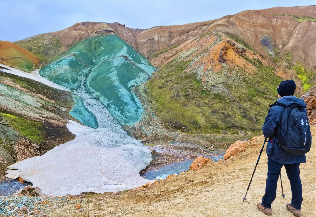
Grænihryggur
The plateau leads to a ridge that can get you all the way right next to Graenihryggur. At this part of the trail, we were able to observe Graenihryggur getting nearer and nearer in front of us with every additional step.
From this ridge, we had to again descend down into the valley and finally reached Graenihryggur with its out-of-this-world colors itself. It’s forbidden to walk over the green ridge, because of the very fragile soil that can be damaged easily. Nevertheless, you can stand by Graenihryggur for as long as you wish and for example take a little picnic, as we did.
This is where the easiest and the most popular “Halldórsgil to Grænihryggur” hiking trail ends. You can then either turn back and follow the same trail back, as we did. Or you can continue with unmarked trails to follow different ways back and/or get to Jökulgil canyon or Landmannalaugar campsite. These trails are more difficult though, and we do not recommend hiking them without extensive hiking skills and/or a local knowledge of the area.
Admiring the famous Grænihryggur green ridge!
Quick hiking Tips
- Choose a nice day. I know it’s easier to be said than done, we’ve been there. But try to choose a nice day. This at least means no stronger rain and no strong fog. We had a light fog and light rain and the hike was nice anyway. Of course, ideally, you aim for clear skies and no fog, but that may be hard to achieve.
- Come with a proper 4×4 car. You’re gonna need it to reach the trail.
- Study beforehand where the trailhead, i.e. the beginning of the trail is located. It may be harder to find, there’s no big sign, nor a car park.
- Bring hiking poles and good physical health. This hike is not for small children, nor for the elderly.
- Some climbs are pretty steep but if you are in a good shape they are definitely doable, no chains, no sharp ridges, just typical slippery Icelandic hiking 🙂
- Enjoy the hike, views, and surroundings are very versatile, Graenihryggur is one of the most beautiful hikes in an entire Iceland in my honest opinion.
![]() ask questions or get inspired in our community
ask questions or get inspired in our community


Hi Igor
Thanks for this information, I’m planning on doing this walk in the summer. I’ve saved your Wikiloc route offline, which I appreciate very much!
kindest regards.
Liz
Thank you Liz! It’s nice to hear from you again. Wishing you an amazing Icelandic holiday!
Thank you for such a detailed hike log! My wife and I are planning on approaching this hike in late August 2024! Hopefully the weather allows. Do you know approximately how many cars can park at the trailhead lot? I am concerned if it happens to be fairly packed where does one park? Thank you. Bryan.
Hi Bryan and thank you! So far we haven’t seen the trailhead lot to be packed/full, so the chances are you will be OK. You can also always ask the rangers on the spot (either at Landmannalaugar campsite or near Holaskjol river crossing)
Igor,
I appreciate the great detail of your hike. My husband and I are going back and forth about this hike or the Blahnúkúr Brennisteinsalda Loop. We will be hiking in 2 weeks. Is one better than another for that time of year? thanks soooo much! Traci
Well Blahnukur/Brennisteinsalda is a bit easier and much more populated. This year there’s already some snow again in the highlands, so this trail is definitely safer. This is the typical “Landmannalaugar view” you will get in here, and it’s beautiful on a clear day.
Graenihryggur, on the other hand, is much more off-the-beaten path, that’s why we like it. Whether it’s more beautiful – it’s hard to tell, I would say it’s equally beautiful. The trail is a bit harder and longer then B.-B.
Hello Igor !
All the way from F208 North to the starting point of Graenihryggur hike, are there any river crossings ? We are with Dacia Duster and I cannot find any info
I believe there’s one or so, small to medium sized. You should be good with Duster.
Hi Igor!
I stumbled upon your website and have been so grateful for all the information and resources. My husband and I are planning our trip to Iceland mid-September of this year. I am pregnant, and I am wondering if you have any resources or guides on shorter, easier hikes and drives that are also scenic or any tour companies that offer such hikes. I appreciate your help already 🙂
Hi Maya, sure, basically most of our “Top Places”: https://epiciceland.net/top-places-to-see-in-iceland/ are short hikes and scenic drives, except the Highlands and full day hikes. To reach most of the waterfalls, hot springs, canyons etc there’s typically a 10 to 30min hiking trails leading to them, which is definitely an easy to moderate hike 🙂
We for example describe difficulties to reach a particular waterfall here: https://epiciceland.net/all-waterfalls-iceland/, the same for hot springs: https://epiciceland.net/all-hot-springs-iceland/ etc.
P.S. If you like what we do please write us a short review on Google: https://g.page/r/CaJt1bHCTbF1EBM/review it would help us a lot!
“It’s NOT a hike for the elderly”
Sorry pal, but at 69 I could hike rings around most 20-somethings. I won’t post my resume, but I have over 50 year experience on long distance trails worldwide, and I know a lot of older people with similar experience. So stick it with the age discrimination!
Dear Jeff, my father is 69 too and he could surely make this hike too, same as you 🙂
This surely isn’t about age discrimination, the more so if you know you are fit enough to do so many hikes – then you really don’t have to take it personal.
We keep getting many questions in the sense of “can I do this hike with my mom/pa with movement problems?” So that particular sentence was meant as a NO for these kinds of questions.
But I agree with you it might have been formulated better – the hike is not for those who are not fit or have mobility issues. Sorry for that.
Hi Igor,
Congrats for your website and impressive amount of information you deliver.
I ‘m planning to visit Iceland with using a 4×4 Campervan. Is it ok to reach the Halldorsgil trailhead from the campsite ?
Thank you very much Patrice!
Yes, 4×4 campervan shall be sufficient, there are no major river crossings between campsite and Halldorsgil trailhead, only smaller ponds if any.
Enjoy your trip!
Hi Igor,
Amazing website you have!
You describe the trail via Halldórsgill as well marked. Does that mean that we can go without a gps? I don’t own a gps. I have the app Wikiloc Premium where I have found your log of this hike. But you say there is no signal on the trail and therefore we cannot use Wikiloc on the way?
Thank you in advance!
Best regards & have a nice summer!
Hi Vibeke and thank you!
Yes you can surely go without a GPS. The later in the season (August, September) you go, the better the trail visibility. Early in the season there’s still snow which might complicate it a bit but nothing too bad. We did it in July without GPS and it was OK, if you have some moderate hiking experience.
Also if you have offline maps on your phone, often it works with your phone GPS (not always though).
P.S.: If you like what we do at Epic Iceland and/or if you appreciate my response, please a short review on Google: https://g.page/r/CaJt1bHCTbF1EBM/review would really help us. Thanks in advance.